ملف:Sig.jpg
لا توجد دقة أعلى متوفرة.
Sig.jpg (620 × 275 بكسل حجم الملف: 74 كيلوبايت، نوع MIME: image/jpeg)
وصف قصير
| Description |
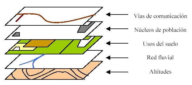
Español: Organización de la información espacial en capas en un SIG. Autor: Corso (27 de julio de 2003). |
| Date | قالب:Original upload date |
| Source | قالب:Transferred from |
| Author | Corso |

 |
This diagram image was uploaded in a raster graphics format such as PNG, GIF, or JPEG. However, it contains information that could be stored more efficiently and/or accurately in the SVG format, as a vector graphic. If possible, please upload an SVG version of this image. After confirming it is of comparable quality, please replace all instances of the previous version throughout Wikipedia (noted under the "File links" header), tag the old version with {{Vector version available|NewImage.svg}}, and remove this tag. For more information, see Wikipedia:Preparing images for upload. For assistance with converting to SVG, please see the Graphics Lab.Do not re-draw or auto-trace non-free images; instead, seek out vector versions from official sources. |
 |
ترخيص

|
⧼wm-license-original-upload-log⧽
قالب:Original description page
- 2003-12-06 01:23 Moriel 620×275×8 (75646 bytes) copiado de EL para el articulo Sistema_de_Información_Geográfica
تاريخ الملف
اضغط على زمن/تاريخ لرؤية الملف كما بدا في هذا الزمن.
| زمن/تاريخ | صورة مصغرة | الأبعاد | مستخدم | تعليق | |
|---|---|---|---|---|---|
| حالي | ★ مراجعة معتمدة 07:36، 13 ديسمبر 2023 | | 620 × 275 (74 كيلوبايت) | Pastakhov (نقاش | مساهمات) | Upload https://upload.wikimedia.org/wikipedia/commons/e/ef/Sig.jpg |
لا يمكنك استبدال هذا الملف.
وصلات
لا يوجد صفحات تصل لهذه الصورة.
