ملف:Sable island.jpg
حجم هذه المعاينة: 598 × 600 بكسل. البعد الآخر: 637 × 639 بكسل.
الملف الأصلي (637 × 639 بكسل حجم الملف: 103 كيلوبايت، نوع MIME: image/jpeg)
وصف قصير
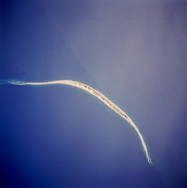
| Description | Satellite image of Sable Island (Canada). STS059-216-079 Sable Island, Nova Scotia, Canada April 1994 Sable Island is a low sandy island approximately 25 miles (40 km) long and 1 mile (1.5 km) wide in the Atlantic Ocean. Located 115 miles (180 km) southeast of Cape Canso, Nova Scotia, the island is the exposed part of a sand shoal that extends northeast/southwest for more than 100 miles (160 km). Sable Island, known as the “graveyard of the Atlantic Ocean,” has been a major hazard to navigation. The island is also noted as a breeding ground for seals, which are protected by the Canadian government. The island helps to mark the western edge of the northeasterly flowing warm waters of the Gulf Stream. |
| Date | 1994-04 |
| Source | eol.jsc.nasa.gov |
| Author | NASA |
| ⧼wm-license-information-other-versions⧽ | قالب:DerivativeVersions |
ترخيص
تاريخ الملف
اضغط على زمن/تاريخ لرؤية الملف كما بدا في هذا الزمن.
| زمن/تاريخ | صورة مصغرة | الأبعاد | مستخدم | تعليق | |
|---|---|---|---|---|---|
| حالي | ★ مراجعة معتمدة 15:26، 5 أكتوبر 2023 | | 637 × 639 (103 كيلوبايت) | Pastakhov (نقاش | مساهمات) | Upload https://upload.wikimedia.org/wikipedia/commons/5/52/Sable_island.jpg |
لا يمكنك استبدال هذا الملف.
وصلات
لا يوجد صفحات تصل لهذه الصورة.