ملف:Prairie du Chien.png
لا توجد دقة أعلى متوفرة.
Prairie_du_Chien.png (300 × 388 بكسل حجم الملف: 68 كيلوبايت، نوع MIME: image/png)

|
[All images in this gallery should be recreated using vector graphics as an SVG file. This has several advantages; see Commons:Media for cleanup for more information. If an SVG form of this image is already available, please upload it. After uploading an SVG, replace this template with {{vector version available|new image name.svg}}.] Error: {{Lang}}: text has italic markup (help) |
|
العربية | български | català | čeština | dansk | Deutsch | English | Esperanto | español | français | galego | 한국어 | italiano | magyar | lietuvių | 日本語 | Plattdüütsch | Nederlands | norsk | polski | português | română | русский | suomi | svenska | Türkçe | українська | 中文(繁體) | 中文(简体) | +/− | |
وصف قصير
| Description |
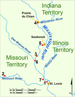
English: Map of the upper Mississippi River during the War of 1812
Fort Belle Fontaine, the U.S. headquarters
Fort Osage, abandoned 1813
Fort Madison, defeated 1813
Fort Shelby, defeated 1814
Battle of Credit Island, Sept. 1814
Fort Johnson, abandoned 1814
Fort Cap au Gris and the Battle of the Sink Hole, May 1815. |
|||||
| Date | 2010-06-29 18:40 (UTC) | |||||
| Source | (Bill Whittaker) created this work entirely by himself. | |||||
| Author | Bill Whittaker | |||||
| ⧼wm-license-information-permission⧽ (⧼wm-license-information-permission-reusing-text⧽) |
|

ترخيص
تاريخ الملف
اضغط على زمن/تاريخ لرؤية الملف كما بدا في هذا الزمن.
| زمن/تاريخ | صورة مصغرة | الأبعاد | مستخدم | تعليق | |
|---|---|---|---|---|---|
| حالي | ★ مراجعة معتمدة 14:06، 28 نوفمبر 2023 | | 300 × 388 (68 كيلوبايت) | Pastakhov (نقاش | مساهمات) | Upload https://upload.wikimedia.org/wikipedia/commons/c/c4/Prairie_du_Chien.png |
لا يمكنك استبدال هذا الملف.
وصلات
لا يوجد صفحات تصل لهذه الصورة.