ملف:Mazama bathymetry survey map.jpg
لا توجد دقة أعلى متوفرة.
Mazama_bathymetry_survey_map.jpg (600 × 345 بكسل حجم الملف: 61 كيلوبايت، نوع MIME: image/jpeg)
| Description |
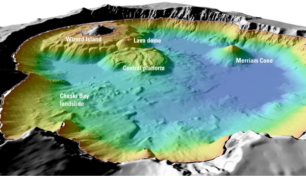
English: "Details of features beneath the surface of Crater Lake constructed using data from the 2000 bathymetry survey. Colors range from orange to blue with increasing water depth." |
| Source | "Mount Mazama and Crater Lake: Growth and Destruction of a Cascade Volcano" |
| Author | U.S. Geological Survey |
ترخيص

This image is a work of a United States Geological Survey employee, taken or made during the course of the person's official duties. As a work of the United States Government, the image is in the public domain. For more information, see the USGS copyright policy.
⧼wm-license-original-upload-log⧽
قالب:Original description page
- 2004-05-18 06:41 Mav 600×345× (62232 bytes) [[USGS]] image from [http://geopubs.wr.usgs.gov/fact-sheet/fs092-02/] <br><br>{{msg:PD}}
تاريخ الملف
اضغط على زمن/تاريخ لرؤية الملف كما بدا في هذا الزمن.
| زمن/تاريخ | صورة مصغرة | الأبعاد | مستخدم | تعليق | |
|---|---|---|---|---|---|
| حالي | ★ مراجعة معتمدة 08:29، 7 نوفمبر 2023 | | 600 × 345 (61 كيلوبايت) | Pastakhov (نقاش | مساهمات) | Upload https://upload.wikimedia.org/wikipedia/commons/1/1c/Mazama_bathymetry_survey_map.jpg |
لا يمكنك استبدال هذا الملف.
وصلات
لا يوجد صفحات تصل لهذه الصورة.
