ملف:Landsat-farallon-de-pajaros-adjusted.png
لا توجد دقة أعلى متوفرة.
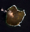
Landsat-farallon-de-pajaros-adjusted.png (97 × 105 بكسل حجم الملف: 40 كيلوبايت، نوع MIME: image/png)
Orthocorrected Landsat 7 image of Farallon de Pajaros, Northern Marianas. Acquired 2000-IV-4; orthocorrected by EarthSat. Source for this dataset was the Global Land Cover Facility Archive copy at the Internet Archive. Levels have been adjusted using GIMP. This is a public domain image.
تاريخ الملف
اضغط على زمن/تاريخ لرؤية الملف كما بدا في هذا الزمن.
| زمن/تاريخ | صورة مصغرة | الأبعاد | مستخدم | تعليق | |
|---|---|---|---|---|---|
| حالي | ★ مراجعة معتمدة 04:30، 11 نوفمبر 2023 | | 97 × 105 (40 كيلوبايت) | Pastakhov (نقاش | مساهمات) | Upload https://upload.wikimedia.org/wikipedia/commons/8/8d/Landsat-farallon-de-pajaros-adjusted.png |
لا يمكنك استبدال هذا الملف.
وصلات
لا يوجد صفحات تصل لهذه الصورة.