ملف:Hispaniola banner Satellite view.jpg
حجم هذه المعاينة: 800 × 115 بكسل. البعد الآخر: 4٬256 × 612 بكسل.
الملف الأصلي (4٬256 × 612 بكسل حجم الملف: 326 كيلوبايت، نوع MIME: image/jpeg)
وصف قصير
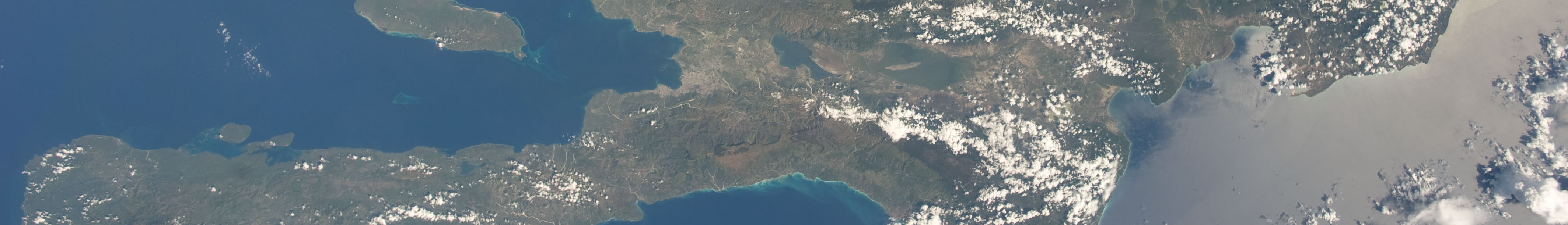
| Description |
English: A view of the Caribbean island of Hispaniola from the International Space Station. This island is comprised of Haiti (in the center left of the image) and the Dominican Republic and is part of the Greater Antilles island chain which lies along the geological border of the North America Plate and the Caribbean Plate. A major fault line in the region, Enriquillo-Plantain Garden Fault, runs along the longer peninsula, in the foreground, and just south of Port-au-Prince. Part of a docked Russian spacecraft can be seen in the foreground. The epicenter of the disastrous 2010 earthquake occurred near this fault. This image was taken by the Expedition 20 crew on the International Space Station on Sept. 28, 2009 using a 25 mm lens setting. |
| Date | 2009-09-28 |
| Source | http://spaceflight.nasa.gov/gallery/images/station/crew-20/html/iss020e043301.html |
| Author | NASA/Expedition 20 crew |
| ⧼wm-license-information-other-versions⧽ | قالب:Extracted from |
ترخيص
تاريخ الملف
اضغط على زمن/تاريخ لرؤية الملف كما بدا في هذا الزمن.
| زمن/تاريخ | صورة مصغرة | الأبعاد | مستخدم | تعليق | |
|---|---|---|---|---|---|
| حالي | ★ مراجعة معتمدة 23:44، 6 أكتوبر 2023 | 4٬256 × 612 (326 كيلوبايت) | Pastakhov (نقاش | مساهمات) | Upload https://upload.wikimedia.org/wikipedia/commons/f/f9/Hispaniola_banner_Satellite_view.jpg |
لا يمكنك استبدال هذا الملف.
وصلات
لا يوجد صفحات تصل لهذه الصورة.