ملف:Gunung Sirung caldera.jpg
لا توجد دقة أعلى متوفرة.
Gunung_Sirung_caldera.jpg (640 × 431 بكسل حجم الملف: 39 كيلوبايت، نوع MIME: image/jpeg)
| Description |
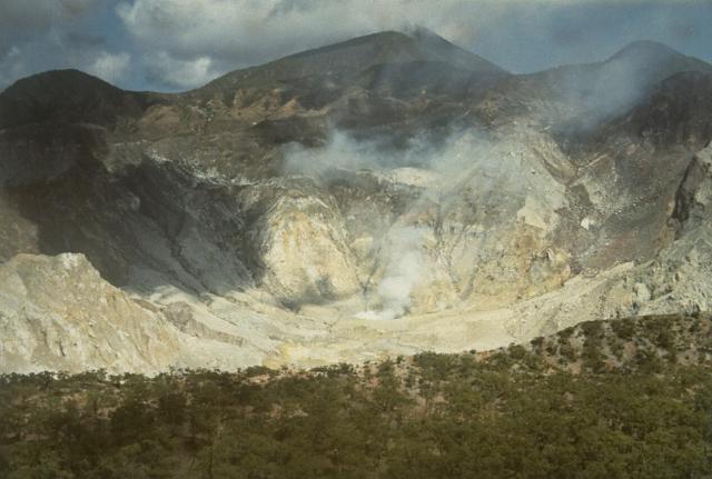
English: The steaming summit caldera of Gunung Sirung volcano is seen here from the eastern caldera rim. Sirung volcano lies at the NE end of a 14-km-long line of volcanic centers forming a peninsula at the southern end of Pantar Island. A lava dome (center) at the western side of the caldera forms the summit of Gunung Sirung volcano; other cones along the chain to the SE increase in height. The 2-km-wide summit caldera has been the source of small phreatic eruptions during the 20th century. |
| Date | 1972 |
| Source | http://www.volcano.si.edu/world/volcano.cfm?vnum=0604-27=&volpage=photos&photo=012044 |
| Author | L.D. Reksowirogo (Volcanological Survey of Indonesia) |
| ⧼wm-license-information-permission⧽ (⧼wm-license-information-permission-reusing-text⧽) |
قالب:PD-IDGov |
تاريخ الملف
اضغط على زمن/تاريخ لرؤية الملف كما بدا في هذا الزمن.
| زمن/تاريخ | صورة مصغرة | الأبعاد | مستخدم | تعليق | |
|---|---|---|---|---|---|
| حالي | ★ مراجعة معتمدة 06:51، 16 أكتوبر 2023 | | 640 × 431 (39 كيلوبايت) | Pastakhov (نقاش | مساهمات) | Upload https://upload.wikimedia.org/wikipedia/commons/f/ff/Gunung_Sirung_caldera.jpg |
لا يمكنك استبدال هذا الملف.
وصلات
لا يوجد صفحات تصل لهذه الصورة.