ملف:Distancia a la costa.png
حجم هذه المعاينة: 800 × 387 بكسل. البعد الآخر: 1٬278 × 619 بكسل.
الملف الأصلي (1٬278 × 619 بكسل حجم الملف: 304 كيلوبايت، نوع MIME: image/png)
وصف قصير
| Description |
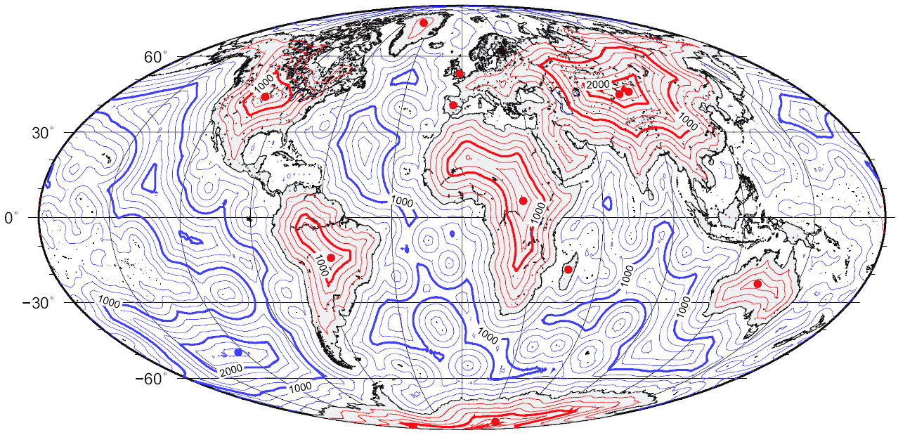
Español: Mapa global de distancia a la línea de costa.
English: Map of great-circle distance to the coastline. |
| Date | 2008 |
| Source | self-made using the technique described in Garcia-Castellanos, D., & U. Lombardo, 2007. Poles of Inaccessibility: a calculation algorithm for the remotest places on Earth. Scott. Geogr. J., 123, 227-233. Based on the coastline database of Wessel, P. & Smith, W. H. F. (1996) A global self-consistent, hierarchical, high-resolution shoreline database, Journal of Geophysical Research, 101, B4, 8741 – 8743. Lake shores are excluded. |
| Author | Gaianauta |

|
[All images in this gallery should be recreated using vector graphics as an SVG file. This has several advantages; see Commons:Media for cleanup for more information. If an SVG form of this image is already available, please upload it. After uploading an SVG, replace this template with {{vector version available|new image name.svg}}.] Error: {{Lang}}: text has italic markup (help) |
|
العربية | български | català | čeština | dansk | Deutsch | English | Esperanto | español | français | galego | 한국어 | italiano | magyar | lietuvių | 日本語 | Plattdüütsch | Nederlands | norsk | polski | português | română | русский | suomi | svenska | Türkçe | українська | 中文(繁體) | 中文(简体) | +/− | |
ترخيص
|

تاريخ الملف
اضغط على زمن/تاريخ لرؤية الملف كما بدا في هذا الزمن.
| زمن/تاريخ | صورة مصغرة | الأبعاد | مستخدم | تعليق | |
|---|---|---|---|---|---|
| حالي | ★ مراجعة معتمدة 03:56، 20 يناير 2024 | | 1٬278 × 619 (304 كيلوبايت) | Pastakhov (نقاش | مساهمات) | Upload https://upload.wikimedia.org/wikipedia/commons/a/ad/Distancia_a_la_costa.png |
لا يمكنك استبدال هذا الملف.
وصلات
لا يوجد صفحات تصل لهذه الصورة.