ملف:Crailing Parish Church - geograph.org.uk - 611779.jpg
لا توجد دقة أعلى متوفرة.
Crailing_Parish_Church_-_geograph.org.uk_-_611779.jpg (610 × 444 بكسل حجم الملف: 124 كيلوبايت، نوع MIME: image/jpeg)
وصف قصير
| Description |
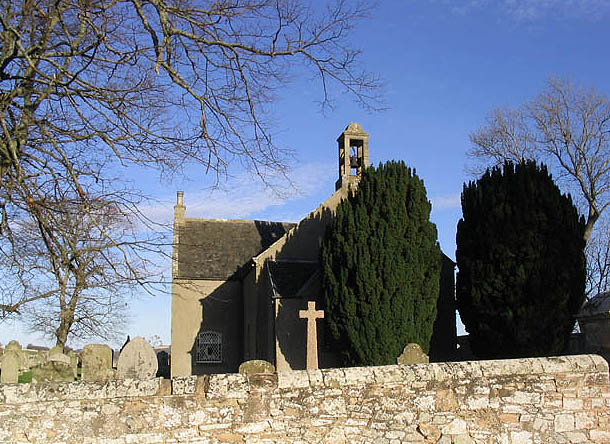
English: Crailing Parish Church The church is situated between Crailing and Nisbet and was built in 1775. The east gallery was exchanged for an apse in 1892 and more recently the burial area has been extended to the northwest. A bird cage belfry on the southwest gable has a bell inscribed "William Lord Cranstoun Crailling for the Church Edr 1706". It has a substantial bell chain. (Source: The Churches and Graveyards of Roxburghshire by G.A.C.Binnie).
Viewed from a minor road at the edge of the square. |
| Date | 2007-11-12 |
| Source | From geograph.org.uk |
| Author | Walter Baxter |
| ⧼wm-license-cc-attribution⧽ (قالب:I18n/Credit line) |
Walter Baxter / Crailing Parish Church / |
55°31′05″N 2°30′19″W / 55.51793°N 2.5054°W
_heading:45)
| Object location | ملف:Compass-icon bb NE.svg | View all coordinates using: OpenStreetMap |
|---|
_heading:45.00&language=⧼lang⧽)
ترخيص
تاريخ الملف
اضغط على زمن/تاريخ لرؤية الملف كما بدا في هذا الزمن.
| زمن/تاريخ | صورة مصغرة | الأبعاد | مستخدم | تعليق | |
|---|---|---|---|---|---|
| حالي | ★ مراجعة معتمدة 11:34، 13 أكتوبر 2023 | | 610 × 444 (124 كيلوبايت) | Pastakhov (نقاش | مساهمات) | Upload https://upload.wikimedia.org/wikipedia/commons/1/1a/Crailing_Parish_Church_-_geograph.org.uk_-_611779.jpg |
لا يمكنك استبدال هذا الملف.
وصلات
لا يوجد صفحات تصل لهذه الصورة.