ملف:Barnstaple (Victoria Road) Station - geograph.org.uk - 1762818.jpg
لا توجد دقة أعلى متوفرة.
Barnstaple_(Victoria_Road)_Station_-_geograph.org.uk_-_1762818.jpg (640 × 342 بكسل حجم الملف: 99 كيلوبايت، نوع MIME: image/jpeg)
وصف قصير
| Description |
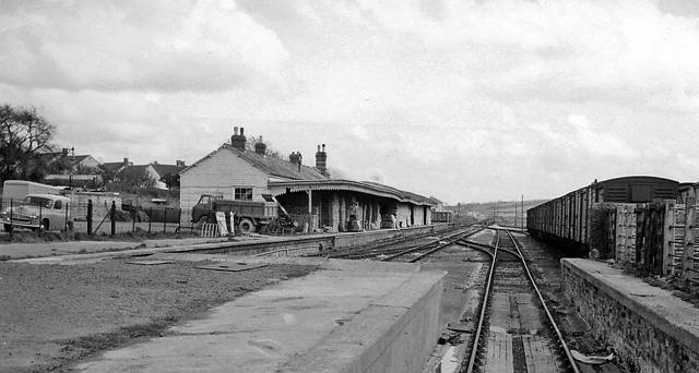
English: Barnstaple (Victoria Road) Station View eastward, towards Taunton, from buffer-stops of disused terminus of former GWR line from Taunton, which also connected with the SR line at Barnstaple Junction until the line was closed entirely on 3/10/66. Meanwhile this station had been closed to passengers on 13/6/60 but to Goods (from Barnstaple Junction) not until 5/3/70. |
| Date | 1964-04-17 |
| Source | From this image at geograph.org.uk; transferred by User:Edward using geograph_org2commons. |
| Author | Ben Brooksbank |
| ⧼wm-license-information-permission⧽ (⧼wm-license-information-permission-reusing-text⧽) |
Creative Commons Attribution Share-alike license 2.0 |
| Object location | ملف:Compass-icon bb ESE.svg | View all coordinates using: OpenStreetMap |
|---|
_Station_-_geograph.org.uk_-_1762818.jpg¶ms=051.075710_N_-004.047700_E_globe:Earth_class:object_type:object_source:geograph-osgb36(SS56643270)_region:GB-ENG_heading:112.00&language=⧼lang⧽)
ترخيص
تاريخ الملف
اضغط على زمن/تاريخ لرؤية الملف كما بدا في هذا الزمن.
| زمن/تاريخ | صورة مصغرة | الأبعاد | مستخدم | تعليق | |
|---|---|---|---|---|---|
| حالي | ★ مراجعة معتمدة 23:43، 5 أكتوبر 2023 | | 640 × 342 (99 كيلوبايت) | Pastakhov (نقاش | مساهمات) | Upload https://upload.wikimedia.org/wikipedia/commons/a/a4/Barnstaple_%28Victoria_Road%29_Station_-_geograph.org.uk_-_1762818.jpg |
لا يمكنك استبدال هذا الملف.
وصلات
لا يوجد صفحات تصل لهذه الصورة.
_Station_-_geograph.org.uk_-_1762818.jpg&oldid=2990719)