ملف:Active COVID-19 cases in Montenegro.png
لا توجد دقة أعلى متوفرة.
Active_COVID-19_cases_in_Montenegro.png (529 × 587 بكسل حجم الملف: 55 كيلوبايت، نوع MIME: image/png)
وصف قصير
| Description |
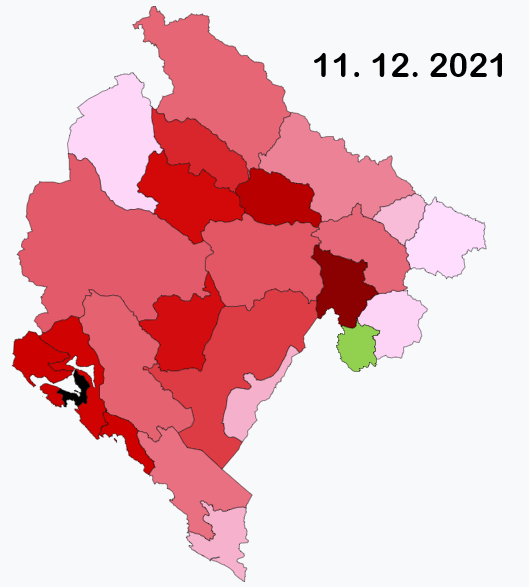
English: This map shows active COVID-19 cases per 100,000 inhabitants by municipality. If the map gets darker, it doesn't actually mean the situation is worsening, but it means there are smaller differences in active cases between municipalities with biggest and lowest number. If the map gets lighter, it means there is a big difference between municipality with highest number of active cases and other municipalities; this often happens if a hotspot appears in some of the municipalities (there is always one municipality black). If a municipality is green, it means there are currently no active cases. Because of small population in most of the municipalities, this map looks different with every daily update and the colours can change very quickly. Data used to create the map come from official Montenegrin COVID-19 statistics page – https://www.covidodgovor.me/me/statistika |
| Date | 2021-03-01 |
| Source | Own work |
| Author | Moson81 |
ترخيص
|
تاريخ الملف
اضغط على زمن/تاريخ لرؤية الملف كما بدا في هذا الزمن.
| زمن/تاريخ | صورة مصغرة | الأبعاد | مستخدم | تعليق | |
|---|---|---|---|---|---|
| حالي | ★ مراجعة معتمدة 23:51، 25 أكتوبر 2023 | | 529 × 587 (55 كيلوبايت) | Pastakhov (نقاش | مساهمات) | Upload https://upload.wikimedia.org/wikipedia/commons/0/07/Active_COVID-19_cases_in_Montenegro.png |
لا يمكنك استبدال هذا الملف.
وصلات
لا يوجد صفحات تصل لهذه الصورة.