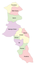
أردبيل
أردبيل
اردبیل | |
|---|---|
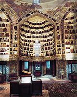
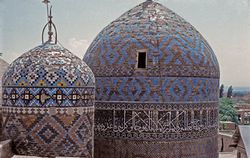 ضريح الشيخ صفي الدين | |
| الإحداثيات: 38°15′N 48°17′E / 38.250°N 48.283°ECoordinates: 38°15′N 48°17′E / 38.250°N 48.283°E | |
| البلد | |
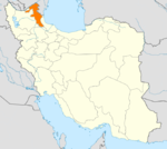
| المحافظة | محافظة أردبيل |
| County | Ardabil County |
| الحكومة | |
| • M.P. | Nouradin Pirmoazen, Vali Azarvash, Hassan No'i-Aghdam |
| • الكيان الحكومي | مجلس مدينة أردبيل |
| المساحة | |
| • الإجمالي | 18٫011 كم² (6٫954 ميل²) |
| المنسوب | 1٬500 m (4٬900 ft) |
| التعداد (2006) | |
| • الإجمالي | 412٬669 |
| • الكثافة | 18٬857/km2 (48٬840/sq mi) |
| منطقة التوقيت | UTC+3:30 (IRST) |
| • الصيف (التوقيت الصيفي) | UTC+4:30 (IRDT) |
| مفتاح الهاتف | 451 |
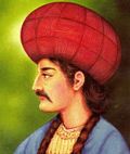
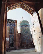
أردبيل، هي مدينة تاريخية في شمال غرب إيران. اشتق اسم أرديبل من الاسم الزرادشتي "أرتاڤيل" ويعني المكان المقدس.[1] أردبيل هي عاصمة محافظة أردبيل. يصل عدد سكانها في 2006 إلى حوالي 412,669[2] ويمثل الأذريون الأغلبية العرقية في السكان. تشتهر المدينة بتجارة الحرير والسجاد، ويعتبر سجاد أردبيل من أجود أنواع السجاد الفارسي. وتشتهر أردبيل أيضا بضريح الشيخ صفي الدين الأردبيلي مؤسس الأسرة الصفوية.
. . . . . . . . . . . . . . . . . . . . . . . . . . . . . . . . . . . . . . . . . . . . . . . . . . . . . . . . . . . . . . . . . . . . . . . . . . . . . . . . . . . . . . . . . . . . . . . . . . . . . . . . . . . . . . . . . . . . . . . . . . . . . . . . . . . . . . . . . . . . . . . . . . . . . . . . . . . . . . . . . . . . . . . .
الموقع
تقع أردبيل على بعد حوالي 70 كم من بحر قزوين، 210 كم عن مدينة تبريز. وعلى متوسط إرتفاع 1263 متر وتصل مساحتها إلى 18.011 كم².
التاريخ
المناخ
| بيانات مناخ أردبيل | |||||||||||||
|---|---|---|---|---|---|---|---|---|---|---|---|---|---|
| الشهر | يناير | فبراير | مارس | أبريل | مايو | يونيو | يوليو | أغسطس | سبتمبر | اكتوبر | نوفمبر | ديسمبر | العام |
| العظمى المتوسطة °س (°ف) | 3.0 (37.4) |
4.5 (40.1) |
9.3 (48.7) |
16.7 (62.1) |
19.7 (67.5) |
23.2 (73.8) |
25.0 (77) |
24.7 (76.5) |
22.6 (72.7) |
17.5 (63.5) |
11.4 (52.5) |
5.7 (42.3) |
15٫28 (59٫5) |
| الصغرى المتوسطة °س (°ف) | -7.9 (17.8) |
-6.3 (20.7) |
-2.4 (27.7) |
2.8 (37) |
6.0 (42.8) |
9.0 (48.2) |
11.6 (52.9) |
11.6 (52.9) |
8.7 (47.7) |
4.8 (40.6) |
0.3 (32.5) |
-4.6 (23.7) |
2٫8 (37٫04) |
| هطول mm (inches) | 24.7 (0.972) |
21.8 (0.858) |
37.4 (1.472) |
38.3 (1.508) |
45.1 (1.776) |
19.4 (0.764) |
6.7 (0.264) |
5.4 (0.213) |
9.9 (0.39) |
33.0 (1.299) |
37.1 (1.461) |
25.1 (0.988) |
303٫9 (11٫965) |
| Avg. precipitation days | 8.0 | 8.5 | 11.2 | 11.5 | 13.7 | 6.9 | 3.9 | 3.8 | 5.8 | 8.8 | 7.5 | 7.7 | 97٫3 |
| Source: World Meteorological Organisation (UN) [3] | |||||||||||||
الديموغرافيا
- السكان (الحضر): حوالي 650,000
- الدين: الأغلبية شيعة
- العرقية: الأغلبية أذريون إيرانيون
- اللغة: معظم السكان يتحدثون الأذرية، بالرغم من أن أغلب سكان أردبيل يفهمون ويتحدثون الفارسية بطلاقة.
المعالم
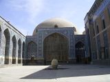 ضريح الشيخ صفي الدين الأردبيلي |
| المعلم | الوصف | |
|---|---|---|
| مجمع الشيخ صفي الدين أردبيلي | هو موقع تراث عالمي، يتكون من العناصر التالية: ضريح الشيخ صفي و الشاه إسماعيل الأول، Chini khaneh (meaning the house of chinaware), a mosque, Jannat Sara (meaning the house of paradise), Khanaqah (the house of Dervishes), Cheragh Khaneh (the house of lamps), Shahid khaneh (the house of martyrs) and Chelleh Khaneh (the place where devotees shut themselves up during the forty days of Lent). The mausoleum of Sheikh Safi, the dome of which is called "Allah-Allah" has an octagonal interior.(Virtual tour) | |
| المسجد الجامع | Ruins of once magnificent and unique Mosque. | |
| مسجد ومدرسة مرزا علي أكبر | This comlex dates back to Qajar period | |
| بازار أردبيل | This beautiful Persian bazaar was built during Safavid period and in addition to main bazaar hall with open vaults has a hammam and a small yet mystifying mosque. | |
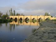
| جسور أردبيل | Ardabil host numerous historical bridges namely Pol-e Gilandeh, Pol-e Nayer, Pol-e Haft Cheshmeh, Pol-e Panj Cheshmeh and Pol-e She Cheshmeh and Qarah Soo Bridge, most were built during Safavid era. | |
| ضريح إمامزاده صالح | The mausoleum of Imamzadeh Saleh who is a descendant of a Shia Imam was built 250 years ago. | |
| كنيسة القديسة ماري | This Armenian orthodox church has a beautiful wooden main door and painted dome built in 1876. | |
| ضريح الشيخ جبرائيل | located 2 km north of Ardabil | |
| سوق قديم ولكن دائم الحيوية | ||
| باباداوود أنباران | مسجد الجمعة |
الجيولوجيا
| المعلم | الوصف |
|---|---|
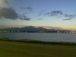
| بحرية شورابيل | located in a hilly area south of the city of Ardabil and covers an area of 640,000 m². The surface of the lake is covered with a thin white layer of minerals, being useful for healing skin diseases and rheumatism. Near the lake there is the leisure complex of Shorabil. |
| Baliqly Chay River | Meaning "a river with many fish" in Azarbayjani language, this river originates from the Sabalan Mountains and passes through Ardabil city. As a result, many villages and townships have settled around this river. It also irrigates much of the agricultural lands in this province. |
| جبل سبلان (سولان) | Sabalan (فارسية: سبلان Sabalân; also called Sāvālān) is an inactive stratovolcano in Meshkinshahr Ardabil province of northwestern Iran about 20 miles west of Arbadil. Sabalan is the third highest mountain in Iran and a permanent crater lake has formed at the summit. Sabalan has a ski resort (Alvares) and different tourist areas such as the Sarein spa. The mountain is known for its beautiful vistas, including the Shirvan gorge, where few climbers ever venture. |
. . . . . . . . . . . . . . . . . . . . . . . . . . . . . . . . . . . . . . . . . . . . . . . . . . . . . . . . . . . . . . . . . . . . . . . . . . . . . . . . . . . . . . . . . . . . . . . . . . . . . . . . . . . . . . . . . . . . . . . . . . . . . . . . . . . . . . . . . . . . . . . . . . . . . . . . . . . . . . . . . . . . . . . .
الموسيقى
الجامعات والكليات
- جامعة أردبيل للعلوم الطبية
- Mohaghegh Ardabili University
- جامعة أزد الإسلامي في أردبيل
- Payam Noor University of Ardabil
- Soureh University of Ardabil
- Islamic Azad University of Khalkhal
الاقتصاد
مشاهير أردبيل
الرياضة
معرض الصور
قبر الشيخ صافي
بازار أردبيل
بحيرة شرابيل
Ash Dough، الأكلة الأردبيلية الشهيرة
انظر أيضا
المصادر
- ^ Iranian Provinces: Ardabil
- ^ http://amar.sci.org.ir/
- ^ "World Weather Information Service – Ardabil". United Nations. Retrieved 01 January 2011.
{{cite web}}: Check date values in:|accessdate=(help)
وصلات خارجية
- Short description is different from Wikidata
- Coordinates on Wikidata
- Pages using infobox settlement with unknown parameters
- Articles containing فارسية-language text
- Articles with hatnote templates targeting a nonexistent page
- مدن إيران
- أردبيل
- محافظة أردبيل
- عواصم محافظات إيرانية
- مدن محافظة أردبيل
- أماكن مأهولة على طريق الحرير


