تشىشر
Cheshire | |||||||||||||||||||||||||||||
|---|---|---|---|---|---|---|---|---|---|---|---|---|---|---|---|---|---|---|---|---|---|---|---|---|---|---|---|---|---|
 Flag | |||||||||||||||||||||||||||||
 | |||||||||||||||||||||||||||||
| الإحداثيات: 53°10′N 2°35′W / 53.167°N 2.583°WCoordinates: 53°10′N 2°35′W / 53.167°N 2.583°W | |||||||||||||||||||||||||||||
| البلد | المملكة المتحدة | ||||||||||||||||||||||||||||
| المقاطعة | إنگلترة | ||||||||||||||||||||||||||||
| المنطقة | North West | ||||||||||||||||||||||||||||
| التأسيس | Ancient | ||||||||||||||||||||||||||||
| منطقة التوقيت | UTC±00:00 (توقيت گرينتش المتوسط) | ||||||||||||||||||||||||||||
| • الصيف (التوقيت الصيفي) | UTC+01:00 (توقيت بريطانيا الصيفي) | ||||||||||||||||||||||||||||
| أعضاء البرلمان | List of MPs | ||||||||||||||||||||||||||||
| الشرطة | Cheshire Constabulary | ||||||||||||||||||||||||||||
| |||||||||||||||||||||||||||||

تشـِشـَر (Cheshire ؛ /ˈtʃɛʃər,_ʔɪər/ CHESH-ər, -eer;[2] archaically the County Palatine of Chester)[3] هي مقاطعة في شمال غربي إنجلترا، تشتهر بصناعة الأجبان وتعدين الملح وهندسة السكك الحديدية والزراعة. وكان التعديل الذي أجري في نظام الحكومة المحلية بإنجلترا عام 1974، قد غيّر كثيرًا في حدود تششر، خاصة وأنه اقتطع منها الشريط الساحلي الذي يطل على البحر الأيرلندي.
. . . . . . . . . . . . . . . . . . . . . . . . . . . . . . . . . . . . . . . . . . . . . . . . . . . . . . . . . . . . . . . . . . . . . . . . . . . . . . . . . . . . . . . . . . . . . . . . . . . . . . . . . . . . . . . . . . . . . . . . . . . . . . . . . . . . . . . . . . . . . . . . . . . . . . . . . . . . . . . . . . . . . . . .
الحكومة المحلية

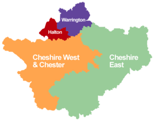
تنقسم المقاطعة إلى 8 محافظات، ومركزها الإداري تشيستر، أما أهم مدنها فهي: تشيستر، وارنتون، آلسميربورت، وايدنس، كرو، رنكورن، ماكسفيلد. تبلغ مساحة المقاطعة 2,330كم²، ويبلغ عدد سكانها 937,300 نسمة.
السكان
الأعراق
Ethnic white groups accounted for 98% (662,794) of the population with 10,994 (2%) in ethnic groups other than white. Of the 2% in non-white ethnic groups:
- 3,717 (34%) belonged to mixed ethnic groups
- 3,336 (30%) were Asian or Asian British
- 1,076 (10%) were Black or Black British
- 1,826 (17%) were of Chinese ethnic groups
- 1,039 (9%) were of other ethnic groups.[4]
يمارس السكان جميع أنواع الرياضات، مثل كرة القدم والكريكيت وسباق الخيل.
الاقتصاد
تعد الصناعة النشاط الاقتصادي الأهم في شمالي تششير حيث تنتشر صناعة السيارات والمواد البتروكيميائية والأدوية وقاطرات السكك الحديدية والإسمنت والمصنوعات الجلدية والفولاذية. ولمزارع الأبقار التي تنتج الألبان أهمية كبيرة في تششير. فمعظم الحليب يستخدم في صناعة الأجبان التي تشتهر بها المقاطعة. ويربي بعض المزارعين الدواجن والأغنام. وتمثل البطاطس والقمح والشعير والشوفان أهم المحاصيل الزراعية للمقاطعة. أما بالنسبة للتعدين، فقد ظلت المقاطعة تنتج الملح منذ وقت طويل، كما أن بها محاجر لتعدين رمل السليكا.
تنتشر بالمقاطعة شبكة من الطرق البرية والسكك الحديدية والقنوات الملاحية لنقل المسافرين والبضائع.
الجغرافيا
السطح
.JPG)

تعد تششير مقاطعة داخلية، تحدها مقاطعتي مانشستر الكبرى وميرسيسايد من الشمال وديربيشاير من الشمال الشرقي وستافوردشاير من الجنوب الشرقي وشروبشاير من الجنوب وكلويد من الغرب. وتنتشر تلال البينانيز على حدودها الشرقية، ويجري خلالها نهرا دي وميرسي. أما البحيرات فتتركز في وسط وشرقي المقاطعة.
المناخ
تمتاز تششير بمناخ معتدل، مع ازدياد في نسبة الرطوبة في مناطق التلال شرقي المقاطعة. ويبلغ متوسط الأمطار فيها حوالي 70 ملم. أما درجات الحرارة فتتراوح بين 4°م في شهر يناير و16°م في شهر يوليو.
التاريخ
بنى الرومانيون قلعة ديف مكان مدينة تشيستر الحالية عام 80م. وكانت مدينة تشيستر آخر المدن الإنجليزية التي رضخت لسيطرة وليم الفاتح (1070م). وقد عاقب النورمنديون سكان تشيستر بمصادرة أراضيهم. وبعد نهاية الغزو النورمندي، صارت تشيستر محافظة اقطاعية يديرها إيرل تشستر، الذي ظل يملك كل أراضيها، ما عدا تلك التي تتبع الكنيسة، حتى عهد هنري الثامن.
المباني والمنشآت
- Gallery
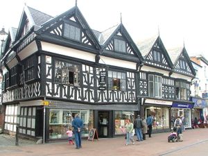
Nantwich High Street
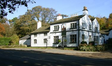
The Wizard Pub, Alderley Edge


.JPG)
.jpg)
السياسة والادارة
الحالية
| District | Administrative HQ | Population (2008 تق.) | Area (km2) | Density (km2) | Leader | Executive | ||
|---|---|---|---|---|---|---|---|---|
| Cheshire East | 
|
Sandbach | 370,700 | 1166 | 318 | |||
| Cheshire West and Chester | Winsford Ellesmere Port | 329,500 | 916.7 | 359 | ||||
| Halton | Widnes | 125,700 | 79.09 | 1589 | Rob Polhill |
| ||
| Warrington | Warrington | 202,700 | 180.6 | 1122 | Terry O'Neill |
| ||
المستوطنات

| Ceremonial county | District | Centre of administration | البلدات والمدن الأخرى |
|---|---|---|---|
| Cheshire | Cheshire East (unitary) | Sandbach | Alsager, Bollington, Crewe, Congleton, Knutsford, Macclesfield, Middlewich, Nantwich, Wilmslow |
| Cheshire West and Chester (unitary) | Chester | Ellesmere Port, Frodsham, Malpas, Neston, Northwich, Winsford | |
| Halton (borough) (unitary) | Widnes | Runcorn | |
| Warrington (borough) (unitary) | Warrington | (none) |
| Derbyshire | Newtown, Tintwistle, Whaley Bridge (western part) |
|---|---|
| Greater Manchester | Altrincham, Bramhall, Bredbury, Cheadle, Cheadle Hulme, Dukinfield, Gatley, Hazel Grove, Hyde, Marple, Romiley, Sale, Stalybridge, Stockport, Wythenshawe |
| Merseyside | Bebington, Birkenhead, Heswall, Hoylake, Wallasey, West Kirby |
. . . . . . . . . . . . . . . . . . . . . . . . . . . . . . . . . . . . . . . . . . . . . . . . . . . . . . . . . . . . . . . . . . . . . . . . . . . . . . . . . . . . . . . . . . . . . . . . . . . . . . . . . . . . . . . . . . . . . . . . . . . . . . . . . . . . . . . . . . . . . . . . . . . . . . . . . . . . . . . . . . . . . . . .
الهامش والمصادر
الهامش
- ^ "Cheshire 2019/2020". High Sheriff of Cheshire website.
- ^ "Cheshire". Random House Webster's Unabridged Dictionary.
- ^ "Relationships / unit history of Cheshire". A Vision of Britain through Time website. Retrieved 5 مارس 2007.
- ^ "Key Statistics Interim Profile" (PDF). Cheshire County Council. Retrieved 6 مارس 2007.
ببليوگرافيا
- Beck, J. (1969). Tudor Cheshire. (Volume 7 of Cheshire Community Council Series: A History of Cheshire). Series Editor: J. J. Bagley. Chester, UK: Cheshire Community Council.
- Bu'Lock, J. D. (1972). Pre-Conquest Cheshire 383-1066. (Volume 3 of Cheshire Community Council Series: A History of Cheshire). Series Editor: J. J. Bagley. Chester, UK: Cheshire Community Council.
- Crosby, A. (1996). A History of Cheshire. (The Darwen County History Series.) Chichester, UK: Phillimore & co. Ltd. ISBN 0850339324.
- Dore, R.N. (1966). The Civil Wars in Cheshire. (Volume 8 of Cheshire Community Council Series: A History of Cheshire). Series Editor: J. J. Bagley. Chester, UK: Cheshire Community Council.
- Driver, J. T. (1971). Cheshire in the Later Middle Ages 1399-1540. (Volume 6 of Cheshire Community Council Series: A History of Cheshire). Series Editor: J. J. Bagley. Chester, UK: Cheshire Community Council.
- Harris, B. E. (1979). 'The Victoria History of the County of Chester. (Volume 2). Oxford: Oxford University Press. ISBN 019722749X.
- Harris, B. E. (1980). 'The Victoria History of the County of Chester. (Volume 3). Oxford: Oxford University Press. ISBN 0197227546.
- Harris, B. E., and Thacker, A. T. (1987). The Victoria History of the County of Chester. (Volume 1: Physique, Prehistory, Roman, Anglo-Saxon, and Domesday). Oxford: Oxford University Press. ISBN 0197227619.
- Hewitt, H. J. (1967). Cheshire Under the Three Edwards. (Volume 5 of Cheshire Community Council Series: A History of Cheshire). Series Editor: J. J. Bagley. Chester, UK: Cheshire Community Council.
- Higham, N. J. (1993). The Origins of Cheshire. Manchester, UK: Manchester University Press. ISBN 0719031605.
- Hodson, J. H. (1978). Cheshire, 1660-1780: Restoration to Industrial Revolution. (Volume 9 of Cheshire Community Council Series: A History of Cheshire). Series Editor: J. J. Bagley. Chester, UK: Cheshire Community Council. ISBN 0903119110.
- Husain, B. M. C. (1973). Cheshire Under the Norman Earls 1066-1237. (Volume 4 of Cheshire Community Council Series: A History of Cheshire). Series Editor: J. J. Bagley. Chester, UK: Cheshire Community Council.
- Morgan, P. (Ed.) (1978). Domesday Book. Volume 26: Cheshire. Chichester, Sussex: Phillmore and Company Limited. ISBN 0850331404.
- Morgan, V., and Morgan, P. (2004). Prehistoric Cheshire. Ashbourne, Derbyshire:Landmark Publishing Company. ISBN 1843061406.
- Phillips, A. D. M., and Phillips, C. B. (Eds.) (2002). A New Historical Atlas of Cheshire. Chester, UK: Cheshire County Council and Cheshire Community Council Publications Trust. ISBN 0904532461.
- Scard, G. (1981). Squire and Tenant: Rural Life in Cheshire 1760-1900. (Volume 10 of Cheshire Community Council Series: A History of Cheshire). Series Editor: J. J. Bagley. Chester, UK: Cheshire Community Council. ISBN 0903119137.
- Scholes, R. (2000). The Towns and Villages of Britain: Cheshire. Wilmslow, Cheshire: Sigma Press. ISBN 1850586373.
- Starkey, H. F. (1990), Old Runcorn, Halton Borough Council
- Sylvester, D. (1980). A History of Cheshire, (The Darwen County History Series.) (Second Edition, original publication date, 1971). London and Chichester, UK: Phillimore & Co. Ltd. ISBN 0850333849.
- Sylvester. D., and Nulty, G. (1958). The Historical Atlas of Cheshire. (Third Edition) Chester, UK: Cheshire Community Council.
- Thompson, F. H. (1965). Roman Cheshire. (Volume 2 of Cheshire Community Council Series: A History of Cheshire). Series Editor: J. J. Bagley. Chester, UK: Cheshire Community Council.
- Tigwell, R. E. (1985). Cheshire in the Twentieth Century. (Volume 11 of Cheshire Community Council Series: A History of Cheshire). Series Editor: J. J. Bagley. Chester, UK: Cheshire Community Council.
- Varley, W. J. (1964). Cheshire Before the Romans. (Volume 1 of Cheshire Community Council Series: A History of Cheshire). Series Editor: J. J. Bagley. Chester, UK: Cheshire Community Council.
- Youngs, F. A. (1991). Guide to the Local Administrative Units of England. (Volume 1: Northern England). London: Royal Historical Society. ISBN 0861931270.
وصلات خارجية
| Cheshire
]].- Cheshire East Council and Cheshire West and Chester Council: Working in Partnership
- Office of National Statistics - 2001 Bicentenary - Cheshire
- Cheshire Wildlife Trust
- The Historic Society of Lancashire and Cheshire
- rECOrd (Local Biological Records Centre for Cheshire)
- تشىشر at the Open Directory Project
| تششاير |  | |
|---|---|---|
| كمبريا | Allerdale • Barrow-in-Furness • Carlisle • Copeland • إدن • South Lakeland | |
| مانشستر الكبرى | ||
| لانكشاير | Blackburn with Darwen • Blackpool • Burnley • Chorley • Fylde • Hyndburn • لانكستر • Pendle • Preston • Ribble Valley • Rossendale • South Ribble • غرب لانكستر • Wyre | |
| مرسياسايد | ||