ملف:Flood Basalt Map.jpg
حجم هذه المعاينة: 800 × 500 بكسل. البعد الآخر: 1٬152 × 720 بكسل.
الملف الأصلي (1٬152 × 720 بكسل حجم الملف: 138 كيلوبايت، نوع MIME: image/jpeg)
وصف قصير
| ⧼wm-license-information-description⧽ |
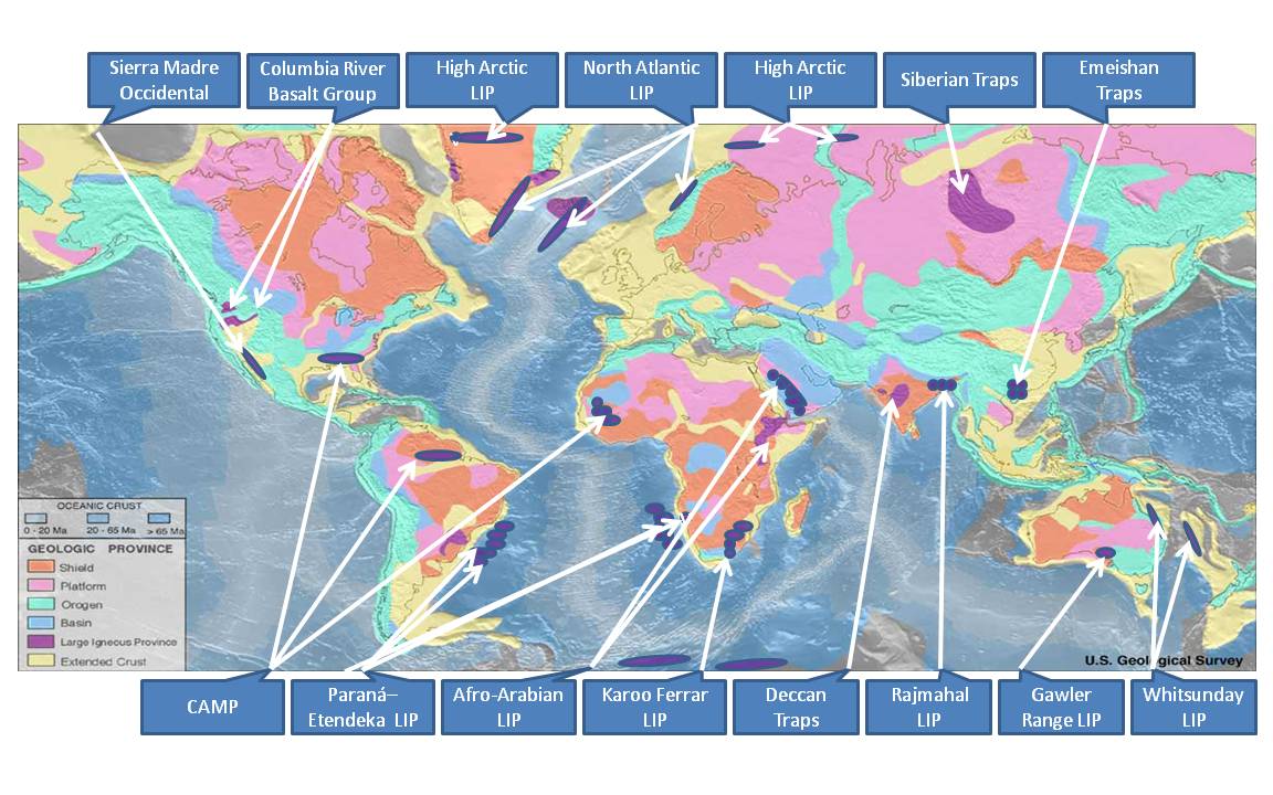
English: This file is an identification of large igneous provinces overlaid on a map produced by United States National Oceanic and Atmosphere Administration's National Geophysical Data Center. Intended for use in the Large igneous province page.
|
| ⧼wm-license-information-date⧽ | 2011 |
| ⧼wm-license-information-source⧽ | ⧼Wm-license-own-work⧽ - based on markup of Source: https://earthquake.usgs.gov/research/structure/crust/maps.php ; original upload english wikipedia 22 April 2005 by SEWilco. The source figure is in the public domain because it contains materials that originally came from the United States Geological Survey, an agency of the United States Department of Interior. For more information, see the official USGS copyright policy. |
| ⧼wm-license-information-author⧽ | Williamborg |

ترخيص
|
تاريخ الملف
اضغط على زمن/تاريخ لرؤية الملف كما بدا في هذا الزمن.
| زمن/تاريخ | صورة مصغرة | الأبعاد | مستخدم | تعليق | |
|---|---|---|---|---|---|
| حالي | ★ مراجعة معتمدة 23:16، 6 نوفمبر 2023 | | 1٬152 × 720 (138 كيلوبايت) | Pastakhov (نقاش | مساهمات) | Upload https://upload.wikimedia.org/wikipedia/commons/0/02/Flood_Basalt_Map.jpg |
لا يمكنك استبدال هذا الملف.
وصلات
لا يوجد صفحات تصل لهذه الصورة.
تصنيفات:
- Self-published work
- Volcanic plateaus
- Basalt
- World maps of volcanoes
- Geological maps of the world
- Flood basalts
- North Atlantic LIP
- Sierra Madre Occidental Volcanic Province
- Columbia River Basalt Group
- High Arctic LIP
- Siberian Traps
- Emeishan Traps
- CAMP (LIP)
- Paraná-Etendeka-LIP
- Afro-Arabian LIP
- Deccan Traps
- Rajmahal LIP
- Karoo Ferrar LIP
- Gawler Range LIP
- Whitsunday LIP
- Maps of Large Igneous Provinces
- Large Igneous Provinces