خروق
Khorugh
| |
|---|---|
 | |
 Seal | |
 Khorugh Location of Khorugh in Tajikistan | |
| الإحداثيات: 37°29′30″N 71°33′21″E / 37.49167°N 71.55583°E | |
| Country | |
| Region | Gorno-Badakhshan Autonomous Region |
| المنسوب | 2٬123 m (6٬965 ft) |
| التعداد (2020)[1] | |
| • الإجمالي | 30٬500 |
| منطقة التوقيت | GMT+5 |
| مفتاح الهاتف | +992 3522 |
| Climate | BSk |
| Official languages | |
The town of Khorugh (روسية: Хорог, romanized: Khorog, بالطاجيكية: Хоруғ, فارسية: خاروغ, Latin Tajik alphabet: بالطاجيكية: Xoruƣ)[أ] is the capital of the Gorno-Badakhshan (روسية: Горно-Бадахшанская автономная область, romanized: Gorno-Badahšanskaja avtonomnaja oblastj; بالطاجيكية: Кӯҳистони Бадахшон, Köhistoni Badaxshon, "Badakhshan Mountainous Region") Autonomous Region (GBAO) in Tajikistan. It is also the capital of the Shughnon District of Gorno-Badakhshan. It has a population of 30,500 (2020 estim.).[1]
Khorugh is 2,200 metres (7,200 ft) above sea level in the Pamir Mountains (ancient Mount Imeon) at the confluence of the rivers Ghunt and Panj. The city is bounded to the south (Nivodak) and to the north (Tem) by the deltas of the Shakhdara and Ghunt, respectively. The two rivers merge in the eastern part of the city flow through the city, dividing it almost evenly until its delta in the Panj, on the border with Afghanistan. Khorugh is known for its poplar trees that dominate the flora of the city.
. . . . . . . . . . . . . . . . . . . . . . . . . . . . . . . . . . . . . . . . . . . . . . . . . . . . . . . . . . . . . . . . . . . . . . . . . . . . . . . . . . . . . . . . . . . . . . . . . . . . . . . . . . . . . . . . . . . . . . . . . . . . . . . . . . . . . . . . . . . . . . . . . . . . . . . . . . . . . . . . . . . . . . . .
History

Until the late 19th century, Khorugh was in an area disputed between the Emir of Bukhara, Shah of Afghanistan, Russia and Britain. The Russians emerged the winners of the region after The Great Game, which fixed the current northern border of Afghanistan on the Panj River and established the territory of Russian Pamir around Khorugh.
Before 1896, when the Russians arrived and built a fort, the main town in the area was Kala-i Bar Panj (or Bar Panja Qal'a) somewhat downriver on the Afghan side. Following the fall of czarist Russia and the rise of the Soviet Union, Khorugh became the capital of Gorno-Badakhshan in 1925. Soviet leaders encouraged the migration of settlers to the area with promises of pay, medals and automobiles, but with no industry and little arable land, the effort was not successful.
Khorugh occupied headlines in July 2012 due to a government forces clash with guerrillas. Over 40 people, including 12 soldiers were killed (many reports indicated that the number of casualties could be higher). The country’s security forces moved in to arrest suspects in the murder of secret services General Abdullo Nazarov. The alleged criminals were linked to former guerrilla leader-turned-border patrol commander Tolib Ayombekov. Ayombekov is alleged to have been involved in drug trafficking and the smuggling of tobacco and precious stones for many years.[3] In 2014, 2018 and again in 2021, Khorugh was the scene of violent clashes and demonstrations against suspected human rights violations by security forces.[4]
Pamir's botanical garden is the most popular view of Khorog. It was established in 1940 to test the survival rate of various plants in mountain climate conditions. More than 30,000 varieties of plants have been checked according to official statistics, which now covers around 4,000 types of garden collection. Located close to Khorog, the botanic garden of Pamir opens up a great panoramic view of the entire city.[5]
Facilities and education
Modern Khorugh is one of the poorest areas of Tajikistan, with the charitable organization Aga Khan Foundation providing almost the only source of cash income. However, the city does have its own university (Khorugh State University), founded in 1992), twelve schools, and several hospitals. There is a museum, the Khorugh Regional Museum,[6] an Ismaili Centre,[7] and the second-highest botanical garden in the world, the Pamir Botanical Garden.[8][9]

Khorugh is also host to the Aga Khan Lycee and one of the three campuses of the University of Central Asia (UCA). The university was founded in 2000 by the governments of Kazakhstan, the Kyrgyz Republic and Tajikistan, and The Aga Khan. It is the world’s first internationally chartered institution of higher education. UCA has three Schools - School of Arts and Sciences, Graduate School of Development and the School of Professional and Continuing Education. The Khorugh Campus offers Bachelor of Arts and Bachelor of Science degrees in Global Economics and Earth and Environmental Sciences.[10]
Transportation
There is a bridge to the Afghan side of the river. Khorugh is situated along the Pamir Highway at the point where it leaves the Panj valley and heads east up the Ghunt valley. The Pamir highway is the main road in Gorno-Badakhshan and connects the Tajik capital of Dushanbe toward the west to the Republic of Kyrgyzstan to the northeast.
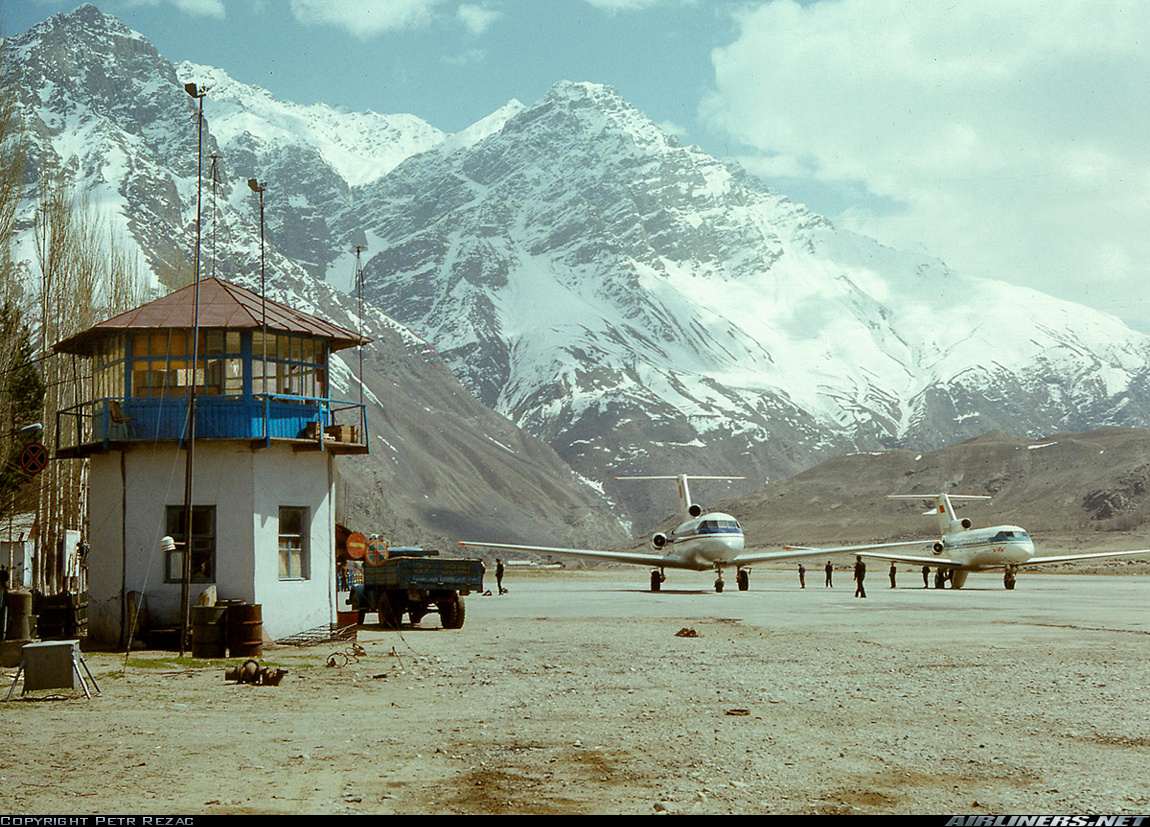
The highway is very difficult to pass in both directions, especially during winter and spring. Khorugh also has a small airport, which can accommodate smaller airplanes like AN-28 turboprop and the Yakovlev YAK-40, or helicopters.
Climate
Khorugh experiences a semi-arid climate (Köppen climate classification BSk) with cold, snowy winters and hot, dry summers.
| بيانات مناخ Khorugh (1961–1990, extremes 1898–present) | |||||||||||||
|---|---|---|---|---|---|---|---|---|---|---|---|---|---|
| الشهر | يناير | فبراير | مارس | أبريل | مايو | يونيو | يوليو | أغسطس | سبتمبر | اكتوبر | نوفمبر | ديسمبر | العام |
| العظمى القياسية °س (°ف) | 11.8 (53.2) |
12.6 (54.7) |
21.6 (70.9) |
30.0 (86) |
36.2 (97.2) |
38.2 (100.8) |
37.9 (100.2) |
38.2 (100.8) |
39.7 (103.5) |
29.5 (85.1) |
20.5 (68.9) |
14.0 (57.2) |
39٫7 (103٫5) |
| العظمى المتوسطة °س (°ف) | -1.2 (29.8) |
0.6 (33.1) |
6.8 (44.2) |
15.7 (60.3) |
21.4 (70.5) |
26.6 (79.9) |
30.1 (86.2) |
30.4 (86.7) |
26.1 (79) |
18.2 (64.8) |
9.5 (49.1) |
2.3 (36.1) |
15٫5 (59٫9) |
| الصغرى المتوسطة °س (°ف) | -11.2 (11.8) |
-8.9 (16) |
-1.7 (28.9) |
5.2 (41.4) |
8.6 (47.5) |
12.1 (53.8) |
15.2 (59.4) |
15.1 (59.2) |
9.9 (49.8) |
4.1 (39.4) |
-1.1 (30) |
-6.5 (20.3) |
3٫4 (38٫1) |
| الصغرى القياسية °س (°ف) | -27.1 (-16.8) |
-26.6 (-15.9) |
-19.8 (-3.6) |
-7.6 (18.3) |
-1.3 (29.7) |
1.9 (35.4) |
7.4 (45.3) |
5.4 (41.7) |
1.5 (34.7) |
-14.0 (6.8) |
-13.2 (8.2) |
-24.7 (-12.5) |
−27٫1 (−16٫8) |
| هطول mm (inches) | 33.8 (1.331) |
35.5 (1.398) |
45.6 (1.795) |
42.2 (1.661) |
29.9 (1.177) |
8.4 (0.331) |
3.4 (0.134) |
1.4 (0.055) |
1.0 (0.039) |
5.6 (0.22) |
7.5 (0.295) |
11.5 (0.453) |
225٫8 (8٫89) |
| % Humidity | 72.2 | 70.7 | 61.8 | 51.6 | 52.8 | 48.0 | 43.9 | 40.7 | 43.8 | 54.3 | 60.1 | 64.9 | 55٫4 |
| Avg. precipitation days | 11.5 | 13.2 | 16.4 | 13.5 | 12.2 | 5.7 | 3.7 | 1.4 | 1.0 | 5.6 | 7.5 | 11.5 | 103٫2 |
| Sunshine hours | 108 | 103 | 139 | 178 | 223 | 262 | 269 | 275 | 245 | 181 | 144 | 105 | 2٬232 |
| Source #1: World Meteorological Organisation (average high and low/precipitation/precipitation days 1961–1990),[11] NOAA (sun 1961–1990)[12] | |||||||||||||
| Source #2: climatebase.ru (humidity),[13] Meteo Climat (record highs and lows)[14] | |||||||||||||
Sports
Khorugh is the locality of highest altitude where bandy has been played.[15]
Photo gallery


. . . . . . . . . . . . . . . . . . . . . . . . . . . . . . . . . . . . . . . . . . . . . . . . . . . . . . . . . . . . . . . . . . . . . . . . . . . . . . . . . . . . . . . . . . . . . . . . . . . . . . . . . . . . . . . . . . . . . . . . . . . . . . . . . . . . . . . . . . . . . . . . . . . . . . . . . . . . . . . . . . . . . . . .
Notes
- ^ also transliterated as Horog, Khoroq, Khorogh, Khorog, or Xoroq
المراجع
- ^ أ ب "Population of the Republic of Tajikistan as of 1 January 2020" (PDF) (in الروسية). Statistics office of Tajikistan. Retrieved 3 October 2020.
- ^ "КОНСТИТУЦИЯ РЕСПУБЛИКИ ТАДЖИКИСТАН". prokuratura.tj. Parliament of Tajikistan. Retrieved 9 January 2020.
- ^ "Government Forces Clash with Guerrillas in Tajikistan". The Gazette of Central Asia. Satrapia. 24 Jul 2012. Retrieved 4 August 2012.
- ^ Roof-top Info (15 January 2022). "What is happening in Tajikistan? Background information on the situation in Khorugh" (PDF). Retrieved 16 January 2022.
- ^ "Khorog". Retrieved March 23, 2021.
{{cite web}}: CS1 maint: url-status (link) - ^ "Regional Museum". lonelyplanet.com. Retrieved 4 February 2018.
- ^ "Khorog Travel Guide". Caravanistan (in الإنجليزية الأمريكية). Retrieved 2019-07-06.
- ^ "Pamir Botanical Garden". lonelyplanet.com. Retrieved 2 February 2018.
- ^ "Pamir Botanical garden". traveltajikistan.net. Retrieved 4 February 2018.
- ^ "Undergraduate Programme - University of Central Asia". www.ucentralasia.org. Retrieved 2016-10-10.
- ^ "World Weather Information Service – Khorog". World Meteorological Organization. Retrieved 18 December 2019.
- ^ "Horog (Khorog) Climate Normals 1961–1990". National Oceanic and Atmospheric Administration. Retrieved 18 December 2019.
- ^ "Khorog,Tajikistan". Climatebase.ru. Retrieved 1 February 2013.
- ^ "Station Khorog" (in الفرنسية). Meteo Climat. Retrieved 18 December 2019.
- ^ Фоминых, Борис (15 January 2011). "Опубликован календарь матчей турнира по хоккею с мячом Азиады-2011" (in الروسية). Bandynet. Retrieved 21 February 2015.
وصلات خارجية
- "Welcome to Xoroq (Khorogh)", © Tirdâd Gorgâni, May 2005; (web archive, 1 August 2008).
- http://www.pamirs.org
- Photo of Khorugh Airport: https://imgproc.airliners.net/photos/airliners/4/1/3/1101314.jpg?v=v40 (found on https://www.airliners.net/photo/Aeroflot/Yakovlev-Yak-40/1101314).
- A Bird's Eye View of Khorugh: https://www.flickr.com/photos/ed_hill/205843943/
Coordinates: 37°29′N 71°33′E / 37.483°N 71.550°E
| النواحي |  | |
|---|---|---|
| المدن والبلدات الرئيسية | ||
| الجغرافيا | ||
| الأنهار | ||
- CS1 الروسية-language sources (ru)
- CS1 maint: url-status
- CS1 الإنجليزية الأمريكية-language sources (en-us)
- CS1 الفرنسية-language sources (fr)
- Short description is different from Wikidata
- Articles containing طاجيكية-language text
- Articles containing روسية-language text
- Articles containing فارسية-language text
- Coordinates on Wikidata
- Populated places in Gorno-Badakhshan