ملف:World 1936 empires colonies territory.png
حجم هذه المعاينة: 800 × 327 بكسل. البعد الآخر: 1٬527 × 624 بكسل.
الملف الأصلي (1٬527 × 624 بكسل حجم الملف: 44 كيلوبايت، نوع MIME: image/png)
1936 coolio stuff
وصف قصير
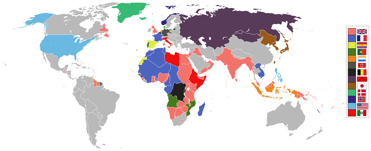
العربية: القوى والمستعمرات العالمية قبل الحرب العالمية الثانية
English: world empires and colonies 1936 (before the Second World War) derived from Image:BlankMap-World-WWII.PNG
العربية
المتحدالمملكة ة
فرنسا
إسبانيا
البرتغال
هولندا
ألمانيا النازية
بلجيكا
الاتحاد السوفيتي
اليابان
الدنمارك
النرويج
الولايات المتحدة
إيطاليا
البلدان المستقلة/غير ذلك
English
UK and Commonwealth
France
Spain
Portugal
Netherlands
Germany
Belgium
USSR
Japan
Denmark
Norway
USA
Italy
Independent/other countries
മലയാളം
യുകെ, കോമൺവെൽത്ത്
ഫ്രാൻസ്
സ്പെയിൻ
പോർച്ചുഗൽ
നെതർലാൻഡ്സ്
നാസി ജർമ്മനി
ബെൽജിയം
സോവിയറ്റ്
ജപ്പാൻ
ഡെന്മാർക്ക്
നോർവേ
യുഎസ്എ
ഇറ്റലി
സ്വതന്ത്ര / മറ്റു രാജ്യങ്ങൾ
Deutsch
Großbritannien
Frankreich
Spanien
USSR
Japan
USA
Italien
Unabhängig / andere Länder
한국어
영국
프랑스
스페인
포르투갈
네덜란드
독일
벨기에
소련
일본
덴마크
노르웨이
미국
이탈리아
독립국/기타
Українська
Великобританія
Франція
Іспанія
Португалія
Нідерланди
Бельгія
СРСР
Японія
Данія
Норвегія
США
Італія
Незалежні держави/колонії інших країн
简体中文
法兰西(第三)共和国(法国)
西班牙(第二)共和国(西班牙)
葡萄牙(第二)共和国(葡萄牙)
荷兰王国(荷兰)
德意志(第三)帝国(德国)
比利时王国(比利时)
苏维埃社会主义共和国联盟(苏联)
大日本帝国(日本)
丹麦王国(丹麦)
挪威王国(挪威)
美利坚合众国(美国)
意大利王国(意大利)
其余独立国家与地区
繁體中文
英國
法國
西班牙
葡萄牙
荷蘭
德國
比利時
蘇聯
日本
丹麥
挪威
美國
義大利
其他國家/獨立
|
|
This Historical map image was uploaded in a raster graphics format such as PNG, GIF, or JPEG. However, it contains information that could be stored more efficiently and/or accurately in the SVG format, as a vector graphic. If possible, please upload an SVG version of this image. After confirming it is of comparable quality, please replace all instances of the previous version throughout Wikipedia (noted under the "File links" header), tag the old version with {{Vector version available|NewImage.svg}}, and remove this tag. For more information, see Wikipedia:Preparing images for upload. For assistance with converting to SVG, please see the Graphics Lab.Do not re-draw or auto-trace non-free images; instead, seek out vector versions from official sources. |
 |
| ملف:Under section sign, hammer and sickle.svg | Legal disclaimer This image contains a symbol prohibited by law in some nations, owing to it being a representation of communism, socialism, or a similar governmental structure; or of an associated political party/organization:
Imagery covered may include the hammer and sickleen, red star, emblems/insignias, flags or images of leaders. |
| ملف:Under section sign, swastika.svg | Legal disclaimer This image shows (or resembles) a symbol that was used by the National Socialist (NSDAP/Nazi) government of Germany or an organization closely associated to it, or another party which has been banned by the Federal Constitutional Court of Germany. The use of insignia of organizations that have been banned in Germany (like the Nazi swastika or the arrow cross) may also be illegal in Austria, Brazil, the Czech Republic, France, Hungary, Poland, Russia, Ukraine and other countries, depending on context. In Germany, the applicable law is paragraph 86a of the criminal code (StGB), in Poland – Art. 256 of the criminal code (Dz.U. 1997 nr 88 poz. 553). |
See also
ترخيص
تاريخ الملف
اضغط على زمن/تاريخ لرؤية الملف كما بدا في هذا الزمن.
| زمن/تاريخ | صورة مصغرة | الأبعاد | مستخدم | تعليق | |
|---|---|---|---|---|---|
| حالي | ★ مراجعة معتمدة 06:08، 2 ديسمبر 2023 | 1٬527 × 624 (44 كيلوبايت) | Pastakhov (نقاش | مساهمات) | Upload https://upload.wikimedia.org/wikipedia/commons/2/20/World_1936_empires_colonies_territory.png |
لا يمكنك استبدال هذا الملف.
وصلات
لا يوجد صفحات تصل لهذه الصورة.