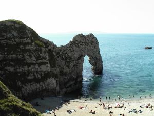
جنوب غرب إنگلترة
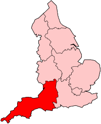 جنوب غرب في إنگلترة | |
| الجغرافيا | |
|---|---|
| الحالة | اقليم |
| المساحة الاجمالية | Ranked 1 23,829 كم² 9,200 ميل² |
| NUTS 1 | UKK |
| الديموغرافيا | |
| اجمالي الكثافة السكانية | الترتيب6 من 9 5,289,000 (2011) 222 كم² |
| القيمة المضافة للفرد | £18,195 (4) |
| الحكومة | |
| المقر الاداري | پلايموث |
| القيادة | مجالس جنوب غرب إنگلترة |
| التنمية المحلية | وكالة التنمية الاقليمية في جنوب غرب إنگلترة |
| البرلمان الأوروپي | جنوب غرب إنگلترة |
| الموقع الإلكتروني | |
جنوب غرب إنگلترة South West England، هو أحد الأقاليم الإنگليزية التسعة. وهو أكبر الأقاليم من حيث المساحة، حيث يغطي مساحة 222 كم²، ويتكون من بريستول، گلوسسترشاير، سمرست، دورست، ويلتشاير، دڤون، كورنوال وجزيرة سيسلي. ويبلغ عدد سكان الاقليم 5 مليون نسمة.
. . . . . . . . . . . . . . . . . . . . . . . . . . . . . . . . . . . . . . . . . . . . . . . . . . . . . . . . . . . . . . . . . . . . . . . . . . . . . . . . . . . . . . . . . . . . . . . . . . . . . . . . . . . . . . . . . . . . . . . . . . . . . . . . . . . . . . . . . . . . . . . . . . . . . . . . . . . . . . . . . . . . . . . .
الجغرافيا
 |
|---|
الجيولوجيا
المناخ
الهوية المحلية
المستوطنات
النقل
التاريخ
ما قبل الرومان
الفترة الرومانية
الفترة النورماندية
العصور الوسطى
. . . . . . . . . . . . . . . . . . . . . . . . . . . . . . . . . . . . . . . . . . . . . . . . . . . . . . . . . . . . . . . . . . . . . . . . . . . . . . . . . . . . . . . . . . . . . . . . . . . . . . . . . . . . . . . . . . . . . . . . . . . . . . . . . . . . . . . . . . . . . . . . . . . . . . . . . . . . . . . . . . . . . . . .
التاريخ الحديث
الديموغرافيا
| البيانات السكانية لجنوب غرب إنگلترة[1] | |
|---|---|
| اجمالي السكان | 4,928,434 |
| المواليد الأجانب | 9.4% |
| بيض | 97.7% |
| آسيويون | 0.7% |
| سود | 0.4% |
| مسيحيون | 74.0% |
| مسلمون | 0.5% |
| هندوس | 0.2% |
| بلا ديانة | 16.8% |
| أكبر من 75 عام | 9.3% |
| عاطلون | 2.6% |
حمل المراهقين
الحرمان الاجتماعي
الانتخابات
اللغان
الاقتصاد والصناعة

. . . . . . . . . . . . . . . . . . . . . . . . . . . . . . . . . . . . . . . . . . . . . . . . . . . . . . . . . . . . . . . . . . . . . . . . . . . . . . . . . . . . . . . . . . . . . . . . . . . . . . . . . . . . . . . . . . . . . . . . . . . . . . . . . . . . . . . . . . . . . . . . . . . . . . . . . . . . . . . . . . . . . . . .
التقسيمات الادارية
الحكومة المحلية
The official region consists of the following geographic counties and local government areas:
| خريطة | Ceremonial county | Shire county / unitary | المقاطعات |
|---|---|---|---|
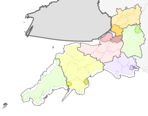 |
سمرست | 1. Bath and North East Somerset UA | |
| 2. شمال سمرست UA | |||
| 11. Somerset CC | a) جنوب سمرست, b) Taunton Deane, c) West Somerset, d) Sedgemoor, e) Mendip | ||
| 3. بريستول UA | |||
| Gloucestershire | 4. South Gloucestershire UA | ||
| 5. Gloucestershire CC | a) Gloucester, b) Tewkesbury, c) Cheltenham, d) Cotswold, e) Stroud, f) Forest of Dean | ||
| Wiltshire | 6. سويندون UA | ||
| 7. Wiltshire UA | |||
| Dorset | 8. Dorset CC | a) Weymouth and Portland, b) West Dorset, c) North Dorset, d) Purbeck, e) East Dorset, f) Christchurch | |
| 9. Poole UA | |||
| 10. Bournemouth UA | |||
| Devon | 12. Devon CC | a) Exeter, b) East Devon, c) Mid Devon, d) North Devon, e) Torridge, f) West Devon, g) South Hams, h) Teignbridge | |
| 13. تورباي UA | |||
| 14. Plymouth UA | |||
| Cornwall | 15. Isles of Scilly sui generis UA | ||
| 16. Cornwall UA | |||
UA = unitary authority CC = مجلس مقاطعة
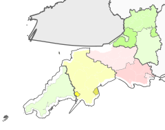
الأقاليم الاحصائية في الاتحاد الأوروپي
| من المستوى 1 | الرمز | من المستوى 2 | الرمز | من المستوى 3 | الرمز |
|---|---|---|---|---|---|
| جنوب غرب إنگلترة | UKK | Gloucestershire, Wiltshire and Bristol/Bath area | UKK1 | بريستول | UKK11 |
|
Bath and North East Somerset, North Somerset and South Gloucestershire | UKK12 | |||
| Gloucestershire CC | UKK13 | ||||
| سويندون | UKK14 | ||||
| Wiltshire | UKK15 | ||||
| دورست وسمرست | UKK2 | Bournemouth and Poole | UKK21 | ||
| دورست CC | UKK22 | ||||
| سمرست | UKK23 | ||||
| Cornwall and Isles of Scilly | UKK3 | Cornwall and Isles of Scilly | UKK30 | ||
| دڤون | UKK4 | Plymouth | UKK41 | ||
| تورباي | UKK42 | ||||
| دڤون CC | UKK43 | ||||
المجلس الاقليمي
السياسة
التعليم
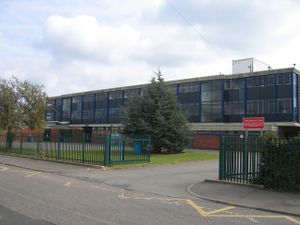
المدارس
التعليم العالي
الاعلام المحلي
المصادر
- ^ United Kingdom Census 2001 (2001). "Key Figures for 2001 Census: Census Area Statistics: Area: Bath and North East Somerset". statistics.gov.uk. Retrieved 12 December 2007.
{{cite web}}: CS1 maint: numeric names: authors list (link)
وصلات خارجية
- Visit South West England – Official Regional Tourist Board
- Invest in South West England – Official Inward Investment Website
- South West England Brand Centre – Information on the South West England promotional brand
- مكتب حكومة جنوب غرب إنگلترة
- Government's list of councils in the South West
- جنوب غرب إنگلترة at the Open Directory Project

