آلانيا، تركيا
آلانيا | |
|---|---|
بلدية ومقاطعة | |
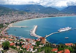 مركز مدينة آلانيا والميناء | |
| الكنية: Güneşin Gülümsediği Yer ("حيث تبتسم الشمس") | |
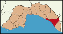 مقاطعة آلانيا في محافظة أنطاليا. | |
| الإحداثيات: 36°33′N 32°00′E / 36.550°N 32.000°E | |
| البلد | |
| المنطقة | المتوسط |
| المحافظة | أنطاليا |
| Incorporated | 1872 |
| الحكومة | |
| • النوع | عمدة قوي-مجلس |
| • العمدة | آدم مراد يوجل (MHP) |
| • الوالي | Dr. Hasan Tanrıseven |
| المساحة | |
| • المقاطعة | 1٬598٫51 كم² (617٫19 ميل²) |
| المنسوب | 0–250 m (0–820 ft) |
| التعداد (2012)[2] | |
| • Urban | 104٬573 |
| • District | 264٬692 |
| • كثافة District | 170/km2 (430/sq mi) |
| صفة المواطن | Alanyalılar |
| منطقة التوقيت | UTC+3 (FET) |
| Postal code | 07400 |
| مفتاح الهاتف | +90 242 |
| Licence plate | 07 |
| الموقع الإلكتروني | www.alanya.bel.tr www.alanya.gov.tr |
آلانيا ( /əˈlɑːnjə/; النطق التركي: [aˈɫanja])، هي مدينة منتجع شاطئية ومقاطعة مكونة من محافظة أنطاليا على الساحل الجنوبي لإيطاليا، في منطقة البحر الأبيض المتوسط في البلاد ، 138 كيلو متر ثانية (453000 قدم) شرق مدينة أنطاليا. اعتبارًا من تعداد تركيا لعام 2010 ، كان عدد سكان المدينة 98627 نسمة ، في حين أن المنطقة التي تضم المدينة والمنطقة المبنية فيها تبلغ مساحتها 1598.51 كيلومترًا مربعًا و 248286 نسمة.[3]
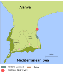
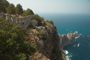
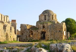
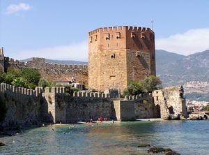
نظرًا لموقعها الاستراتيجي الطبيعي على شبه جزيرة صغيرة في البحر الأبيض المتوسط أسفل جبال طوروس ، كانت ألانيا معقلًا محليًا للعديد من إمبراطوريات البحر الأبيض المتوسط ، بما في ذلك البطلمية و السلوقية و الرومانية و البيزنطية و الدولة العثمانية. جاءت الأهمية السياسية الكبرى لألانيا في العصور الوسطى، مع سلاجقة الروم تحت حكم علاء الدين كيقباد الأول ، الذي اشتق اسم المدينة منه. نتج عن حملته للبناء العديد من معالم المدينة ، مثل Kızıl Kule (البرج الأحمر) و Tersane (حوض بناء السفن) و قلعة ألانيا.
يجعل مناخ البحر المتوسط والمعالم الطبيعية والتراث التاريخي من ألانيا وجهة شهيرة للسياحة ، ومسؤولة عن تسعة بالمائة من قطاع السياحة في تركيا وثلاثين بالمائة من المشتريات الأجنبية للعقارات في تركيا. ارتفعت السياحة منذ عام 1958 لتصبح الصناعة المهيمنة في المدينة ، مما أدى إلى زيادة مقابلة في عدد سكان المدينة. تقام الأحداث الرياضية والمهرجانات الثقافية ذات الطقس الدافئ سنويًا في ألانيا. في عام 2014 رئيس البلدية أطاح آدم مراد يوجل ، من حزب الحركة القومية حسن سيباهي أوغلو ، من حزب العدالة والتنمية، الذي سبق أن قاد المدينة منذ 1999.
. . . . . . . . . . . . . . . . . . . . . . . . . . . . . . . . . . . . . . . . . . . . . . . . . . . . . . . . . . . . . . . . . . . . . . . . . . . . . . . . . . . . . . . . . . . . . . . . . . . . . . . . . . . . . . . . . . . . . . . . . . . . . . . . . . . . . . . . . . . . . . . . . . . . . . . . . . . . . . . . . . . . . . . .
الاسماء
تغيرت يد المدينة مرات عديدة على مر القرون ، واسمها يعكس ذلك. عُرفت ألانيا في اللاتينية باسم "Coracesium" أو في اليونانية باسم "Korakesion" من اللغة اللوڤية "Korakassa" بمعنى "النقطة / مدينة بارزة ".[4] لا تزال الكنيسة الرومانية الكاثوليكية تعترف بالاسم اللاتيني على أنه الاسم الفخري في هرمها.[5] في عهد الامبراطورية البيزنطية أصبحت تُعرف باسم "كالونوروس" أو "كالون أوروس"، بمعنى "الجبل الجميل" في اللغة اليونانية.[6] أعادت السلاجقة تسمية المدينة "Alaiye" (علائیه) ، مشتق من سلطان علاء الدين كايقباد الأول. في القرنين الثالث عشر والرابع عشر ، أطلق التجار الإيطاليون على المدينة اسم "كانديلور" أو "كارديلورو".[7] في زيارته عام 1935 ، أكمل مصطفى كمال أتاتورك الاسم في الأبجدية الجديدة باسم "ألانيا" ، وتغيير الحرفين "i" و "e" في Alaiye ، حسبما ورد ، بسبب خطأ إملائي في برقية عام 1933.[8][9]
التاريخ
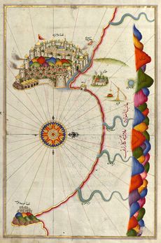
تشير الاكتشافات الموجودة في كهف كارين القريبة إلى الاحتلال خلال العصر الحجري القديم الذي يعود إلى 20،000 قبل الميلاد،[10] وتشير الأدلة الأثرية إلى وجود ميناء في سيدرا ، جنوب المدينة الحديثة ، خلال العصر البرونزي حوالي 3،000 قبل الميلاد.[11] تم العثور على لوح اللغة الفينيقية في المنطقة ويعود تاريخها إلى 625 ق.م.، والمدينة مذكورة بشكل خاص في مخطوطة الجغرافيا اليونانية للقرن الرابع قبل الميلاد، الدليل الملاحي لسكيلاكس الكاذب.[10] من المحتمل أن تكون صخور القلعة مأهولة تحت الحثيين والامبراطورية الأخمينية ، وتم تحصينها لأول مرة في الفترة الهلنستية بعد غزو المنطقة من قبل الإسكندر الأكبر.[12] ترك خلفاء الإسكندر المنطقة لأحد الجنرالات المقدونيين المتنافسين، پطليموس الأول سوتر، بعد وفاة الإسكندر في 323 ق.م.. حافظت سلالته على سيطرة فضفاضة على سكان Isauria بشكل أساسي، وأصبح الميناء ملجأً شعبيًا لقراصنة البحر الأبيض المتوسط.[4] قاومت المدينة أنطيوخوس الثالث الكبير من المملكة السلوقية في 199 ق.م.، لكنها كانت موالية للقرصان ديودوتس تريفون عندما استولى على التاج السلوقي من 142 إلى 138 ق.م. أكمل منافسه أنطيوخس السابع سيدتس العمل في 137 ق.م. على قلعة وميناء جديد ، بدأ في عهد Diodotus.[13]
في معركة كوس داغ عام 1243 ، كسرت جحافل المغول الهيمنة السلجوقية في الأناضول. ثم تعرضت ألانيا لسلسلة من الغزوات من إمارات الأناضول. لوزينيان من قبرص انقلب لفترة وجيزة على الحكم سلالة الحميدية في 1371.[14] باع القرمان المدينة عام 1427 مقابل 5000 قطعة نقدية ذهبية إلى مماليك مصر لفترة قبل أن يدمجها الجنرال جديك أحمد باشا عام 1471 في الإمبراطورية العثمانية المتنامية. أصبحت المدينة عاصمة محلية (سنجق) في محافظة مرسين.[6] مدد العثمانيون حكمهم عام 1477 عندما جلبوا تجارة الشحن الرئيسية وهي الخشب، التي كانت تتم في الغالب بواسطة البندقية ، تحت احتكار الحكومة.[15] في 6 سبتمبر 1608 ، صدت المدينة هجومًا بحريًا شنه وسام القديس ستيفن من جمهورية البندقية.[7]
الجغرافيا
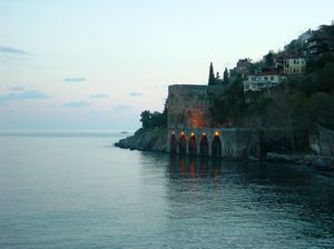
تقع على خليج أنطاليا على سهل الأناضول الساحلي پامفيليا ، وتقع المدينة بين جبال طوروس في الشمال و البحر الأبيض المتوسط ، وهي جزء من الريفيرا التركية ، وتحتل ما يقرب من 70 كم من الساحل.[16] من الغرب إلى الشرق ، تحد مقاطعة ألانيا Manavgat على طول الساحل ، والجبال Gündoğmuş الداخلية ، وHadim و طشقند في محافظة قونية ، Sarıveliler في محافظة قرةمان ، والمقاطعة الساحلية غازيپاشا.[17] مانافجات هي موطن لمدن سيدا القديمة و سيلج. شرق المدينة ، يتدفق نهر ديم من الجبال في قونية على طريق جنوبي غربي إلى البحر الأبيض المتوسط.
المناخ
تتمتع ألانيا بمناخ البحر المتوسط الحار الصيفي النموذجي (كوبن: وكالة الفضاء الكندية). تقع منطقة الضغط العالي شبه الاستوائية في حوض البحر الأبيض المتوسط، وتضمن أن معظم الأمطار تأتي خلال فصل الشتاء، تاركة الصيف طويلًا وساخنًا وجافًا ، مما دفع مجلس ألانيا للسياحة إلى استخدام شعار "حيث تبتسم الشمس".[18] تجلب خلايا العواصف أحيانًا معها مواسير مائية ذات طقس معتدل عندما تكون قريبة من الشاطئ.[19] يتسبب وجود جبل طوروس بالقرب من البحر في حدوث ضباب ، مما يؤدي بدوره إلى ظهور أقواس قزح مرئية في الصباح. يخلق ارتفاع الجبال تأثيرًا مثيرًا للاهتمام حيث يمكن غالبًا رؤية الثلج عليها حتى في الأيام الحارة في المدينة أدناه. يبلغ متوسط درجة حرارة البحر في ألانيا 21.4 درجة مئوية (71 درجة فهرنهايت) سنويًا ، بمتوسط درجة حرارة في أغسطس 28 درجة مئوية (82 درجة فهرنهايت). [20]
| بيانات مناخ آلانيا (1970–2011) | |||||||||||||
|---|---|---|---|---|---|---|---|---|---|---|---|---|---|
| الشهر | يناير | فبراير | مارس | أبريل | مايو | يونيو | يوليو | أغسطس | سبتمبر | اكتوبر | نوفمبر | ديسمبر | العام |
| العظمى القياسية °س (°ف) | 23.2 (73.8) |
25.0 (77) |
28.1 (82.6) |
30.7 (87.3) |
35.4 (95.7) |
37.8 (100) |
40.8 (105.4) |
39.6 (103.3) |
37.2 (99) |
34.9 (94.8) |
30.0 (86) |
24.7 (76.5) |
40٫8 (105٫4) |
| العظمى المتوسطة °س (°ف) | 16.2 (61.2) |
16.3 (61.3) |
18.3 (64.9) |
21.1 (70) |
24.7 (76.5) |
28.7 (83.7) |
31.5 (88.7) |
32.1 (89.8) |
30.2 (86.4) |
26.5 (79.7) |
21.5 (70.7) |
17.8 (64) |
23٫74 (74٫74) |
| المتوسط اليومي °س (°ف) | 11.8 (53.2) |
11.9 (53.4) |
13.8 (56.8) |
16.9 (62.4) |
20.9 (69.6) |
25.1 (77.2) |
27.8 (82) |
28.0 (82.4) |
25.4 (77.7) |
21.2 (70.2) |
16.4 (61.5) |
13.2 (55.8) |
19٫37 (66٫86) |
| الصغرى المتوسطة °س (°ف) | 8.6 (47.5) |
8.5 (47.3) |
10.1 (50.2) |
13.0 (55.4) |
16.7 (62.1) |
20.5 (68.9) |
23.3 (73.9) |
23.7 (74.7) |
21.2 (70.2) |
17.4 (63.3) |
13.0 (55.4) |
10.0 (50) |
15٫5 (59٫9) |
| الصغرى القياسية °س (°ف) | -1.9 (28.6) |
-2.2 (28) |
0.9 (33.6) |
4.0 (39.2) |
9.8 (49.6) |
13.3 (55.9) |
16.9 (62.4) |
14.1 (57.4) |
13.2 (55.8) |
9.5 (49.1) |
2.9 (37.2) |
0.4 (32.7) |
−2٫2 (28) |
| هطول mm (inches) | 199.0 (7.835) |
149.4 (5.882) |
97.8 (3.85) |
70.7 (2.783) |
32.4 (1.276) |
8.5 (0.335) |
4.5 (0.177) |
2.7 (0.106) |
17.5 (0.689) |
98.5 (3.878) |
182.9 (7.201) |
231.2 (9.102) |
1٬095٫1 (43٫114) |
| % Humidity | 57 | 57 | 61 | 63 | 66 | 66 | 64 | 65 | 58 | 55 | 59 | 60 | 60٫9 |
| Avg. rainy days | 13.8 | 11.6 | 9.5 | 8.5 | 4.4 | 1.5 | 0.4 | 0.5 | 2.1 | 6.6 | 9.9 | 13.0 | 81٫8 |
| Sunshine hours | 127.1 | 127.1 | 192.2 | 219.0 | 288.3 | 348.0 | 325.5 | 316.2 | 273.0 | 220.1 | 159.0 | 133.3 | 2٬728٫8 |
| Source #1: Turkish State Meteorological Service[21] | |||||||||||||
| Source #2: Weather2 [22] | |||||||||||||
| Jan | Feb | Mar | Apr | May | Jun | Jul | Aug | Sep | Oct | Nov | Dec |
|---|---|---|---|---|---|---|---|---|---|---|---|
| 17.8 °C (64.0 °F) | 16.9 °C (62.4 °F) | 17.3 °C (63.1 °F) | 17.9 °C (64.2 °F) | 21.2 °C (70.2 °F) | 25.3 °C (77.5 °F) | 27.9 °C (82.2 °F) | 29.0 °C (84.2 °F) | 27.7 °C (81.9 °F) | 24.9 °C (76.8 °F) | 21.2 °C (70.2 °F) | 19.0 °C (66.2 °F) |
. . . . . . . . . . . . . . . . . . . . . . . . . . . . . . . . . . . . . . . . . . . . . . . . . . . . . . . . . . . . . . . . . . . . . . . . . . . . . . . . . . . . . . . . . . . . . . . . . . . . . . . . . . . . . . . . . . . . . . . . . . . . . . . . . . . . . . . . . . . . . . . . . . . . . . . . . . . . . . . . . . . . . . . .
المعالم السياحية الرئيسية
التركيبة السكانية
| Year | District | City |
|---|---|---|
| 1893[24] | 37914 | |
| 1965[25] | 43459 | 12436 |
| 1970[26] | 53552 | 15011 |
| 1975[27] | 63235 | 18520 |
| 1980[28] | 74148 | 22190 |
| 1985[29] | 87080 | 28733 |
| 1990[30] | 129106 | 52460 |
| 2000[31] | 257671 | 88346 |
| 2007[32] | 226236 | 91713 |
| 2008[33] | 233919 | 92223 |
| 2009[34] | 241451 | 94316 |
| 2010[35] | 248286 | 98627 |
| 2011[36] | 259787 | 103673 |
الحضارة
الحكومة
الاقتصاد
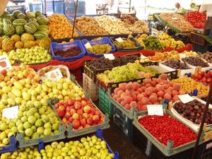
The tourist industry in Alanya is worth just under 1.1 billion euros per year, and is therefore the principal industry.[16] The area is further known for its many fruit farms, particularly lemons and oranges, and large harvests of tomatoes, bananas and cucumbers.[16][37] About 80,000 tonnes of citrus fruits were produced in 2006 across 16,840 hectares (41,600 acres). The greengage plum and the avocado are increasingly popular early season fruits where citrus fruits are becoming unprofitable.[38]
Despite the seaside location, few residents make their living on the sea, and fishing is not a major industry. In the early 1970s, when fish stocks ran low, a system of rotating access was developed to preserve this sector.[39] This innovative system was part of Elinor Ostrom's research on economic governance which led to her 2009 Nobel Prize in Economics.[40] In 2007, locals protested the establishment of some larger chain supermarkets and clothing stores, which have opened branches in Alanya.[41]
Beginning in 2003, with the provisional elimination of restrictions on land purchases by non-nationals, the housing industry in the city has become highly profitable with many new private homes and condominiums being built for European and Asian part-time residents.[42] Sixty-nine percent of homes purchased by foreign nationals in the Antalya Province and 29.9% in all of Turkey are in Alanya.[43][44] Buyers are primarily individuals, rather than investors.[45] This housing boom put pressure on the city's many gecekondu houses and establishments as property values rise and property sales to locals fall.[46] A height restriction in the city limits most buildings to 21 feet (6.5 m).[47] This keeps high rise hotels to the east and west of the city, preserving the central skyline at the expense of greater tourist potential. The fringes of the city however have seen uncontrolled expansion.[48]
السياحة
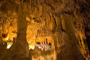
Since the first modern motel was built in 1958, considered the first year of the tourist industry in Alanya, hotels have raced to accommodate the influx of tourists, and the city اعتبارا من 2007[تحديث] claims 157,000 hotel beds.[49][50] Damlataş Cave, which originally sparked the arrival of outsiders because of the cave's microclimate, with an average temperature of 72 °F (22 °C) and 95% humidity, is accessible on the west side of the peninsula with trails from Damlataş Beach.[51] Many tourists, especially Scandinavians, Germans, Russians, and Dutch, regularly vacation in Alanya during the warmer months.[52] They are drawn to the area because of property prices, warm weather, sandy beaches, access to Antalya's historic sites, and fine cuisine.[53]
Other outdoor tourist activities include wind surfing, parasailing, and banana boating. Attractions include Europe's largest waterpark, Sealanya, and Turkey's largest go-kart track.[54] Hunting season also attracts some tourist for wild goat, pig and partridge hunting in area nature reserves.[55]
For various reasons, tourist seasons after 2005 have been disappointing for Alanya's tourism industry. Among the reasons blamed were increased PKK violence, the H5N1 bird flu found in Van, and the Mohammad cartoon controversy.[56] Alanya officials have responded with a variety of publicity initiatives, including baking the world's longest cake on April 26, 2006, a Guinness World Record.[57] The economy has also suffered due to investment in more than 20,000 surplus properties.[41] Israeli tourists, commonly arriving via cruise ship, have also declined sharply by about 85% from 2009 to 2011 due in part to strained relations between Turkey and Israel.[58]
. . . . . . . . . . . . . . . . . . . . . . . . . . . . . . . . . . . . . . . . . . . . . . . . . . . . . . . . . . . . . . . . . . . . . . . . . . . . . . . . . . . . . . . . . . . . . . . . . . . . . . . . . . . . . . . . . . . . . . . . . . . . . . . . . . . . . . . . . . . . . . . . . . . . . . . . . . . . . . . . . . . . . . . .
المدن الشقيقة
منذ إبرام اتفاقيات مع تالسي و تراكاي و Keszthely في 2006، و بوراس في 2007، و روڤانيمي و Špindlerův Mlýn و موسكو في 2009، ازداد عدد المدن الشقيقة لآلانيا إلى اثنتي عشر، عشرة منهن يقعوا في الاتحاد الأوروپي.[59][60][61] In 2005 Alanya applied with Sister Cities International for an additional sister city from the United States.[62] The most significant tie is with the city of Nea Ionia، where many of Alanya's Christians were resettled في 1923 بعد معاهدة لوزان. Soccer teams from sister cities Wodzisław Śląski and Schwechat have also come to train and scrimmage in Alanya.[63][64] Wodzisław, Schwechat, Gladbeck، Fushun، and Alanya form a "family" in that most are partnered with the others. During the annual Tourism and Culture Festival, Alanya dedicates the year to focus on one country, and has involved sister cities, such as Trakai when 2009 was declared the "Year of Lithuania,"[65] and Talsi, which was the focus of the 12th annual Tourism Parade in 2012.[66]
انظر أيضاً
المصادر
- ^ "Area of regions (including lakes), km²". Regional Statistics Database. Turkish Statistical Institute. 2002. Retrieved 2013-03-05.
- ^ "Population of province/district centers and towns/villages by districts - 2012". Address Based Population Registration System (ABPRS) Database. Turkish Statistical Institute. Retrieved 2013-02-27.
- ^ "Statistical Institute page for Antalya". Address Based Population Registration System (ABPRS) Database. Turkish Statistical Institute. 2011. Retrieved August 24, 2011.[dead link]
- ^ أ ب "Alanya – Korekesion". Daily Life, Culture, and Ethnography of Antalya. Antalya Valiliği. February 6, 2008. Archived from the original on August 24, 2007. Retrieved September 7, 2008.
- ^ "Coracesium". Catholic Hierarchy. October 7, 2013. Retrieved January 18, 2015.
- ^ أ ب Crane, Howard (1993). "Evliya Çelebi's Journey through the Pamphylian Plain in 1671-72". Muqarnas. 10 (Essays in Honor of Oleg Grabar): 157–168. doi:10.2307/1523182. JSTOR 1523182.
- ^ أ ب Mason, Roger (1989). "The Medici-Lazara Map of Alanya". Anatolian Studies. 39: 85–105. doi:10.2307/3642815. JSTOR 3642815.
- ^ Yetkin, Haşim (1990). Dünden Bugüne Alanya. Antalya: Yetkin Dağitim. Archived from the original on May 13, 2008. Retrieved March 10, 2008.
{{cite book}}: Unknown parameter|deadurl=ignored (|url-status=suggested) (help) - ^ "Alaiye's Becoming Alanya". Alanyanın Web Sitesi. 2008. Retrieved August 1, 2008.
- ^ أ ب "The History of Alanya". Ministry of Tourism. Retrieved September 7, 2008.
- ^ "Relics of a 5,000-year-old port found in southern Turkey". World Bulletin. August 24, 2011. Retrieved August 29, 2011.
- ^ Rogers, J. M (1976). "Waqf and Patronage in Seljuk Anatolia: The Epigraphic Evidence". Anatolian Studies. 26: 82, 83, 85, 97–98. doi:10.2307/3642717. JSTOR 3642717.
- ^ Acar, Özgen (October 10, 2005). "Alanya's graffiti from the Middle Ages being saved". Turkish Daily News. Archived from the original on April 18, 2013. Retrieved May 2, 2009.
{{cite news}}: Unknown parameter|dead-url=ignored (|url-status=suggested) (help) - ^ "Hamid Dynasty". Hamid Dynasty. 2007. http://search.eb.com/eb/article-9039020. Retrieved on January 29, 2007.
- ^ خطأ استشهاد: وسم
<ref>غير صحيح؛ لا نص تم توفيره للمراجع المسماةInalcik - ^ أ ب ت "Rakamlarla Alanya". Alanya Chamber of Commerce. 2005. Retrieved September 7, 2008.
- ^ Akiş, Ayhan (2007). "Alanya'da Turizm ve Turizmin Alanya Ekonimisine Etkisi". Selcuk Universitesi Sosyal Bilimler Enstitusu Dergisi (17): 15–32. ISSN 1302-1796. Archived from the original on February 13, 2012. Retrieved February 23, 2008.
{{cite journal}}: Unknown parameter|deadurl=ignored (|url-status=suggested) (help) - ^ "Summer sun for southern beaches, eastern Anatolia remains icy". Today's Zaman. February 9, 2008. Retrieved February 10, 2008.[dead link]
- ^ "Waterspouts in Alanya". Istanbul Journal of Weather. Weather Underground. October 19, 2006. Retrieved February 22, 2008.
- ^ "Turkey Statistical Yearbook" (PDF). State Institute of Statistics. 2004. Archived from the original (PDF) on 10 September 2008. Retrieved September 7, 2008.
{{cite web}}: Unknown parameter|deadurl=ignored (|url-status=suggested) (help) - ^ "İl ve İlçelerimize Ait İstatistiki Veriler- Meteoroloji Genel Müdürlüğü". Dmi.gov.tr. December 2012. Archived from the original on 2012-06-04. Retrieved 2019-01-14.
{{cite web}}: Unknown parameter|deadurl=ignored (|url-status=suggested) (help) - ^ "July Climate History for Alanya | Local | Turkey". Myweather2.com. October 2011. Retrieved 2013-03-25.
- ^ "Monthly Alanya water temperature chart". seatemperature.org. Retrieved 23 August 2013.
- ^ خطأ استشهاد: وسم
<ref>غير صحيح؛ لا نص تم توفيره للمراجع المسماةcensus - ^ "1965 genel nüfus sayimi verileri". Türkiye Istatistik Kurumu. 3 November 2012. Archived from the original on 2 November 2012. Retrieved 3 November 2012.
{{cite web}}: Unknown parameter|dead-url=ignored (|url-status=suggested) (help) - ^ "1970 genel nüfus sayimi verileri". Türkiye Istatistik Kurumu. 3 November 2012. Archived from the original on 3 November 2012. Retrieved 3 November 2012.
{{cite web}}: Unknown parameter|dead-url=ignored (|url-status=suggested) (help) - ^ "1975 genel nüfus sayimi verileri". Türkiye Istatistik Kurumu. 3 November 2012. Archived from the original on 3 November 2012. Retrieved 3 November 2012.
{{cite web}}: Unknown parameter|dead-url=ignored (|url-status=suggested) (help) - ^ "1980 genel nüfus sayimi verileri". Türkiye Istatistik Kurumu. 3 November 2012. Archived from the original on 3 November 2012. Retrieved 3 November 2012.
{{cite web}}: Unknown parameter|dead-url=ignored (|url-status=suggested) (help) - ^ "1985 genel nüfus sayimi verileri". Türkiye Istatistik Kurumu. 3 November 2012. Archived from the original on 3 November 2012. Retrieved 3 November 2012.
{{cite web}}: Unknown parameter|dead-url=ignored (|url-status=suggested) (help) - ^ "1990 genel nüfus sayimi verileri". Türkiye Istatistik Kurumu. 3 November 2012. Archived from the original on 3 November 2012. Retrieved 3 November 2012.
{{cite web}}: Unknown parameter|dead-url=ignored (|url-status=suggested) (help) - ^ "2000 genel nüfus sayimi verileri". Türkiye Istatistik Kurumu. 3 November 2012. Archived from the original on 3 November 2012. Retrieved 3 November 2012.
{{cite web}}: Unknown parameter|dead-url=ignored (|url-status=suggested) (help) - ^ "2007 genel nüfus sayimi verileri". Türkiye Istatistik Kurumu. 3 November 2012. Archived from the original on 3 November 2012. Retrieved 3 November 2012.
{{cite web}}: Unknown parameter|dead-url=ignored (|url-status=suggested) (help) - ^ "2008 genel nüfus sayimi verileri". Türkiye Istatistik Kurumu. 3 November 2012. Archived from the original on 3 November 2012. Retrieved 3 November 2012.
{{cite web}}: Unknown parameter|dead-url=ignored (|url-status=suggested) (help) - ^ "2009 genel nüfus sayimi verileri". Türkiye Istatistik Kurumu. 3 November 2012. Archived from the original on 3 November 2012. Retrieved 3 November 2012.
{{cite web}}: Unknown parameter|dead-url=ignored (|url-status=suggested) (help) - ^ "2010 genel nüfus sayimi verileri". Türkiye Istatistik Kurumu. 3 November 2012. Archived from the original on 3 November 2012. Retrieved 3 November 2012.
{{cite web}}: Unknown parameter|dead-url=ignored (|url-status=suggested) (help) - ^ "2011 genel nüfus sayimi verileri". Türkiye Istatistik Kurumu. 3 November 2012. Archived from the original on 3 November 2012. Retrieved 3 November 2012.
{{cite web}}: Unknown parameter|dead-url=ignored (|url-status=suggested) (help) - ^ "Economic Structure of Antalya". Antalya Chamber of Commerce and Industry. 2005.
- ^ Yeşil, Ahmet (April 30, 2008). "Alanya farmers turn to greengage plum, avocado production". Today's Zaman. Archived from the original on September 27, 2012. Retrieved April 30, 2008.
{{cite news}}: Unknown parameter|deadurl=ignored (|url-status=suggested) (help) - ^ "Halting degradation of natural resources". Food and Agriculture Organization. 1996. Retrieved September 7, 2008.
- ^ "Fishermen in Alanya proud to be a part of the Nobel prize". www.alanyaproperties.com. Alanya Properties. Archived from the original on June 22, 2010. Retrieved June 22, 2010.
{{cite news}}: Unknown parameter|deadurl=ignored (|url-status=suggested) (help) - ^ أ ب Boyle, Donna (November 24, 2007). "Which way is progress?". Turkish Daily News. Archived from the original on April 18, 2013. Retrieved May 2, 2009.
{{cite news}}: Unknown parameter|dead-url=ignored (|url-status=suggested) (help) - ^ خطأ استشهاد: وسم
<ref>غير صحيح؛ لا نص تم توفيره للمراجع المسماةreeta - ^ Yilmaz, Fatih; Ahmet Yeşhil Fethiye (May 1, 2008). "Property prices fall with cancellation of law on property sales to foreigners". Today's Zaman. Archived from the original on May 2, 2008. Retrieved May 3, 2008.
- ^ "Antalya's Alanya district attracts foreigner buyers". Turkish Daily News. May 1, 2008. Archived from the original on July 1, 2012. Retrieved September 7, 2008.
{{cite news}}: Unknown parameter|dead-url=ignored (|url-status=suggested) (help) - ^ Yeşil, Ahmet (March 14, 2009). "Foreigners no longer buying real estate for profit in Alanya". Today's Zaman. Archived from the original on December 12, 2013. Retrieved March 14, 2009.
{{cite news}}: Unknown parameter|deadurl=ignored (|url-status=suggested) (help) - ^ Yeşil, Ahmet (October 29, 2007). "Alanya's property sector moribund". Today's Zaman. Archived from the original on December 12, 2013. Retrieved September 7, 2008.
{{cite news}}: Unknown parameter|deadurl=ignored (|url-status=suggested) (help) - ^ "FAQ". Tora Villa Real Estate. March 2005. Retrieved September 7, 2008.
- ^ Leone, Stacie (May 2006). "Burgeoning Alanya". Turkey-Now. Archived from the original on 2007-10-15. Retrieved September 7, 2008.
{{cite web}}: Unknown parameter|dead-url=ignored (|url-status=suggested) (help) - ^ Hakları, Telif (2002). "Belediye Tarihi". Archived from the original on 7 September 2008. Retrieved September 7, 2008.
{{cite web}}: Unknown parameter|deadurl=ignored (|url-status=suggested) (help) - ^ "Campaign calls on Alanya's merchants to respect tourists". Turkish Daily News. June 26, 2007. Archived from the original on July 14, 2012. Retrieved May 2, 2009.
{{cite news}}: Unknown parameter|dead-url=ignored (|url-status=suggested) (help) - ^ "Damlataş Cave". Alanya.com.tr. May 20, 2006. Archived from the original on 2008-02-16. Retrieved February 24, 2008.
{{cite web}}: Unknown parameter|deadurl=ignored (|url-status=suggested) (help) - ^ Griffith, Leslie (May 31, 2007). "While I wasn't sleeping". The Chronicle. Archived from the original on June 22, 2010. Retrieved June 22, 2010.
{{cite news}}: Unknown parameter|deadurl=ignored (|url-status=suggested) (help) - ^ Kremida, Damaris (March 6, 2007). "The boom and bust of Alanya's riviera". Turkish Daily News. Archived from the original on July 1, 2012. Retrieved May 2, 2009.
{{cite web}}: Unknown parameter|dead-url=ignored (|url-status=suggested) (help) - ^ "Europe's biggest water park begins new season". Today's Zaman. May 5, 2009. Archived from the original on January 8, 2016. Retrieved May 5, 2009.
{{cite news}}: Unknown parameter|deadurl=ignored (|url-status=suggested) (help) - ^ "Alanya to attract foreigners for hunting tourism". Turkish Daily News. October 22, 2008. Archived from the original on July 7, 2012. Retrieved May 2, 2009.
{{cite news}}: Unknown parameter|dead-url=ignored (|url-status=suggested) (help) - ^ "Alanya Sees 30% Fall in Scandinavian Tourists". Today's Zaman. March 3, 2006. Archived from the original on May 24, 2008. Retrieved September 7, 2008.
- ^ "Guinness Welcomes World's Longest Cake Baked In Turkey". Turkishpress.com. March 22, 2007. Retrieved September 7, 2008.
- ^ "Alanya no longer attracting Israeli cruise-ship passengers". Hürriyet Daily News and Economic Review. November 24, 2011. Retrieved November 28, 2011.
- ^ "Twins towns". Borås. March 3, 2008. Archived from the original on 20 September 2008. Retrieved September 5, 2008.
{{cite web}}: Unknown parameter|deadurl=ignored (|url-status=suggested) (help) - ^ "Our Sibling Cities". Alanya Municipality. 2009. Archived from the original on 31 January 2009. Retrieved February 1, 2009.
{{cite web}}: Unknown parameter|deadurl=ignored (|url-status=suggested) (help) - ^ "Sistership Agreement with Spindleruv Mlyn of Checz Republic is Signed". Alanya Municipality. December 4, 2009. Archived from the original on July 22, 2011. Retrieved January 25, 2010.
{{cite web}}: Unknown parameter|deadurl=ignored (|url-status=suggested) (help) - ^ "Desired Sister Community: General Information". Sister Cities International. Archived from the original on November 4, 2005. Retrieved September 7, 2008.
- ^ "AlanyaSpor was beaten by sistercity team Schwechat 4-0". Alanya municipality. February 7, 2008. Archived from the original on July 22, 2011. Retrieved September 7, 2008.
{{cite web}}: Unknown parameter|deadurl=ignored (|url-status=suggested) (help) - ^ "Odra Wodzislaw Executives Thanked Sipahioglu". Alanya municipality. February 8, 2008. Archived from the original on July 22, 2011. Retrieved September 7, 2008.
{{cite web}}: Unknown parameter|deadurl=ignored (|url-status=suggested) (help) - ^ "'Lithuania Year' in Alanya". Hurriyet. Anatolian Agency. May 29, 2009. Retrieved May 31, 2009.
- ^ "12th Alanya Tourism fest starts with parade". Hürriyet Daily News. Anatolian Agency. May 28, 2012. Retrieved May 28, 2012.
- ^ Международное сотрудничество города Мурманска
للاستزادة
- Lloyd, Seton; Rice, D.S. (1958). Alanya ('Alā'iyya). London: British Institute of Archaeology at Ankara. OCLC 7230223.
- Redford, Scott. Landscape and the state in medieval Anatolia: Seljuk gardens and pavilions of Alanya, Turkey. Oxford: Archaeopress; 2000. ISBN 1-84171-095-4
وصلات خارجية
- Articles with dead external links from June 2017
- CS1 errors: unsupported parameter
- Short description is different from Wikidata
- Pages using infobox settlement with possible nickname list
- Pages using infobox settlement with unknown parameters
- Pages using infobox settlement with image map1 but not image map
- مقالات فيها عبارات متقادمة منذ 2007
- جميع المقالات التي فيها عبارات متقادمة
- Coordinates on Wikidata
- أقضية أنطاليا
- آلانيا
- موانئ على البحر المتوسط في تركيا
- الريڤييرا التركية
- أماكن مأهولة في محافظة أنطاليا
- Populated coastal places in Turkey
- مجتمعات صيد في تركيا
- مقاطعة آلانيا
- مقاطعات محافظة أنطاليا
- قائمة المواقع المقترحة للتراث العالمي
- Catholic titular sees in Asia

