مقاطعة بكس، پنسلڤانيا
Bucks County | |
|---|---|
| County of Bucks | |
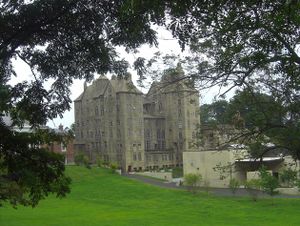
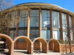 Bucks County Administration Building | |
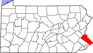 Location within the U.S. state of Pennsylvania | |
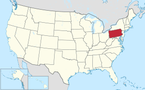 موقع Pennsylvania ضمن الولايات المتحدة | |
| الإحداثيات: Coordinates: 40°20′N 75°07′W / 40.34°N 75.11°W | |
| البلد | |
| State | |
| تأسست | November 1682 |
| السمِيْ | Buckinghamshire |
| Seat | Doylestown |
| Largest township | Bensalem |
| المساحة | |
| • الإجمالي | 622 ميل² (1٬610 كم²) |
| • البر | 604 ميل² (1٬560 كم²) |
| • الماء | 18 ميل² (50 كم²) 2.8%% |
| التعداد | |
| • Estimate (2019) | 628٬270 |
| • الكثافة | 1٬039/sq mi (401/km2) |
| منطقة التوقيت | UTC−5 (Eastern) |
| • الصيف (التوقيت الصيفي) | UTC−4 (EDT) |
| Congressional district | 1st |
| الموقع الإلكتروني | www |
Invalid designation | |
| التوصيف | October 29, 1982[1] |
مقاطعة بكس Bucks County هي مقاطعة تقع في كومنولث پنسلڤانيا. As of the 2010 census, the population was 625,249,[2] making it the fourth-most populous county in Pennsylvania and the 99th-most populous county in the United States. The county seat is Doylestown.[3] The county is named after the English county of Buckinghamshire or more precisely, its abbreviation.
Bucks County constitutes part of the northern boundary of the Philadelphia–Camden–Wilmington, PA–NJ–DE–MD Metropolitan Statistical Area, more commonly known as the Delaware Valley. It is located immediately northeast of Philadelphia and forms part of the southern tip of the eastern state border with New Jersey.
. . . . . . . . . . . . . . . . . . . . . . . . . . . . . . . . . . . . . . . . . . . . . . . . . . . . . . . . . . . . . . . . . . . . . . . . . . . . . . . . . . . . . . . . . . . . . . . . . . . . . . . . . . . . . . . . . . . . . . . . . . . . . . . . . . . . . . . . . . . . . . . . . . . . . . . . . . . . . . . . . . . . . . . .
التاريخ
التأسيس
Bucks County is one of the three original counties created by colonial proprietor William Penn in 1682. Penn named the county after Buckinghamshire, the county where he lived in England. He built a country estate called Pennsbury Manor in Falls Township, Bucks County.
المقاطعات المجاورة
- Lehigh County (northwest)
- Northampton County (north)
- Warren County, New Jersey (northeast)
- Hunterdon County, New Jersey (northeast)
- Mercer County, New Jersey (east)
- Burlington County, New Jersey (southeast)
- Philadelphia County (south)
- Montgomery County (west)
الديمغرافيا
| التعداد التاريخي | |||
|---|---|---|---|
| التعداد | Pop. | %± | |
| 1790 | 25٬216 | — | |
| 1800 | 27٬496 | 9�0% | |
| 1810 | 32٬371 | 17٫7% | |
| 1820 | 37٬842 | 16٫9% | |
| 1830 | 45٬745 | 20٫9% | |
| 1840 | 48٬107 | 5٫2% | |
| 1850 | 56٬091 | 16٫6% | |
| 1860 | 63٬578 | 13٫3% | |
| 1870 | 64٬336 | 1٫2% | |
| 1880 | 68٬656 | 6٫7% | |
| 1890 | 70٬615 | 2٫9% | |
| 1900 | 71٬190 | 0٫8% | |
| 1910 | 76٬530 | 7٫5% | |
| 1920 | 82٬476 | 7٫8% | |
| 1930 | 96٬727 | 17٫3% | |
| 1940 | 107٬715 | 11٫4% | |
| 1950 | 144٬620 | 34٫3% | |
| 1960 | 308٬567 | 113٫4% | |
| 1970 | 410٬056 | 32٫9% | |
| 1980 | 479٬211 | 16٫9% | |
| 1990 | 541٬174 | 12٫9% | |
| 2000 | 597٬635 | 10٫4% | |
| 2010 | 625٬249 | 4٫6% | |
| 2019 (تق.) | 628٬270 | [4] | 0٫5% |
| U.S. Decennial Census[5] 1790-1960[6] 1900-1990[7] 1990-2000[8] 2010-2019[2] | |||
الاقتصاد
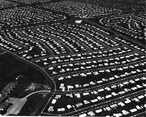
The boroughs of Bristol and Morrisville were prominent industrial centers along the Northeast Corridor during World War II. Suburban development accelerated in Lower Bucks in the 1950s with the opening of Levittown, Pennsylvania, the second such "Levittown" designed by William Levitt.
Among Bucks' largest employers in the twentieth century were U.S. Steel in Falls Township, and the Vulcanized Rubber & Plastics and Robertson Tile companies in Morrisville. Rohm and Haas continues to operate several chemical plants around Bristol. Waste Management operates a landfill in Tullytown that is the largest receptacle of out-of-state waste in the USA (receiving much of New York City's waste following the closure of Fresh Kills landfill in Staten Island, NY 40 miles (64 km) away).[بحاجة لمصدر]
Bucks is also experiencing rapid growth in biotechnology, along with neighboring Montgomery County. The Greater Philadelphia area consistently ranks in the top 10 geographic clusters for biotechnology and biopharma.[9] It is projected by 2020 that one out of four people in Bucks County will work in biotechnology.
السياسة والحكم
| Year | Republican | Democratic | Third parties |
|---|---|---|---|
| 2016 | 47.6% 164,361 | 48.4% 167,060 | 4.0% 13,621 |
| 2012 | 48.7% 156,579 | 50.0% 160,521 | 1.3% 4,166 |
| 2008 | 45.1% 150,248 | 53.7% 179,031 | 1.2% 4,045 |
| 2004 | 48.3% 154,469 | 51.1% 163,438 | 0.6% 1,909 |
| 2000 | 46.3% 121,927 | 50.5% 132,914 | 3.3% 8,581 |
| 1996 | 41.7% 94,899 | 45.4% 103,313 | 12.8% 29,151 |
| 1992 | 38.1% 94,584 | 39.4% 97,902 | 22.5% 56,021 |
| 1988 | 60.0% 127,563 | 38.8% 82,472 | 1.2% 2,605 |
| 1984 | 63.3% 130,119 | 36.3% 74,568 | 0.5% 1,032 |
| 1980 | 55.5% 100,536 | 32.6% 59,120 | 11.9% 21,508 |
| 1976 | 50.7% 85,628 | 47.3% 79,838 | 2.1% 3,457 |
| 1972 | 62.3% 99,684 | 35.5% 56,784 | 2.2% 3,591 |
| 1968 | 48.6% 69,646 | 40.2% 57,634 | 11.1% 15,931 |
| 1964 | 38.9% 50,243 | 60.6% 78,287 | 0.5% 646 |
| 1960 | 54.0% 67,501 | 45.7% 57,177 | 0.4% 438 |
| 1956 | 60.7% 59,862 | 39.1% 38,541 | 0.2% 180 |
| 1952 | 62.4% 40,753 | 37.2% 24,301 | 0.4% 275 |
| 1948 | 62.5% 29,411 | 35.4% 16,655 | 2.2% 1,018 |
| 1944 | 58.6% 25,634 | 40.8% 17,823 | 0.6% 270 |
| 1940 | 54.7% 25,169 | 44.8% 20,586 | 0.5% 229 |
| 1936 | 48.8% 23,860 | 49.4% 24,159 | 1.8% 876 |
| 1932 | 59.1% 22,331 | 37.4% 14,135 | 3.6% 1,341 |
| 1928 | 76.5% 28,421 | 22.7% 8,446 | 0.8% 301 |
| 1924 | 66.9% 17,460 | 25.2% 6,582 | 7.9% 2,066 |
| 1920 | 65.2% 14,130 | 31.7% 6,867 | 3.2% 684 |
| 1916 | 54.0% 9,269 | 43.6% 7,491 | 2.4% 414 |
| 1912 | 32.0% 5,452 | 39.8% 6,773 | 28.2% 4,812 |
| 1908 | 55.3% 9,409 | 42.5% 7,233 | 2.1% 362 |
| 1904 | 57.7% 9,572 | 40.5% 6,719 | 1.8% 290 |
| 1900 | 55.1% 9,263 | 43.4% 7,287 | 1.5% 253 |
| 1896 | 57.6% 9,798 | 39.3% 6,685 | 3.1% 524 |
| 1892 | 48.7% 8,230 | 49.7% 8,390 | 1.6% 272 |
| 1888 | 49.1% 8,584 | 49.4% 8,642 | 1.5% 253 |
| 1884 | 48.4% 8,191 | 50.9% 8,604 | 0.6% 103 |
| 1880 | 49.1% 8,385 | 50.6% 8,627 | 0.2% 35 |
. . . . . . . . . . . . . . . . . . . . . . . . . . . . . . . . . . . . . . . . . . . . . . . . . . . . . . . . . . . . . . . . . . . . . . . . . . . . . . . . . . . . . . . . . . . . . . . . . . . . . . . . . . . . . . . . . . . . . . . . . . . . . . . . . . . . . . . . . . . . . . . . . . . . . . . . . . . . . . . . . . . . . . . .
مفوضو المقاطعة
- Diane Ellis-Marseglia, Chair, Democratic
- Bob Harvie, Democratic
- Gene DiGirolamo, Republican
المناصب الأخرى بالمقاطعة
| Office | Official | Party | Term ends |
|---|---|---|---|
| Clerk of Courts | Brian Munroe | Democratic | 2021 |
| Controller | Neale Dougherty | Democratic | 2021 |
| Coroner | Meredith Buck | Democratic | 2021 |
| Treasurer | Kris Ballerini | Democratic | 2021 |
| District Attorney | Matthew Weintraub | Republican | 2023 |
| Prothonotary | Judi Reiss | Democratic | 2023 |
| Recorder of Deeds | Robin Robinson | Democratic | 2023 |
| Register of Wills | Linda Bobrin | Democratic | 2023 |
| Sheriff | Milton "Milt" Warrell | Democratic | 2023 |
مجلس شيوخ الولاية
| الدائرة | السناتور | الحزب |
|---|---|---|
| 6 | Robert M. Tomlinson | Republican |
| 10 | Steve Santarsiero | Democratic |
| 12 | Maria Collett | Democratic |
| 24 | Bob Mensch | Republican |
مجلس نواب الولاية
مجلس النواب الأمريكي
| الدائرة | النائب | الحزب |
|---|---|---|
| 1 | Brian Fitzpatrick | Republican |
مجلس الشيوخ الأمريكي
| السناتور | الحزب |
|---|---|
| Bob Casey | Democratic |
| Pat Toomey | Republican |
التجمعات السكنية
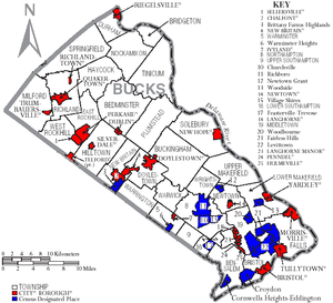
Under Pennsylvania law, there are four types of incorporated municipalities: cities, boroughs, townships, and, in at most two cases, towns. The most populous borough in the county is Morrisville with 10,023 as of the 2000 census. The following boroughs and townships are located in Bucks County:
المراكز
البلدات
- Bedminster
- Bensalem
- Bridgeton
- Bristol
- Buckingham
- Doylestown
- Durham
- East Rockhill
- Falls
- Haycock
- Hilltown
- Lower Makefield
- Lower Southampton
- Middletown
- Milford
- New Britain
- Newtown
- Nockamixon
- Northampton
- Plumstead
- Richland
- Solebury
- Springfield
- Tinicum
- Upper Makefield
- Upper Southampton
- Warminster
- Warrington
- Warwick
- West Rockhill
- Wrightstown
أماكن مذكورة بالتعداد
Census-designated places are geographical areas designated by the U.S. Census Bureau for the purposes of compiling demographic data. They are not actual jurisdictions under Pennsylvania law. Other unincorporated communities, such as villages, may be listed here as well.
. . . . . . . . . . . . . . . . . . . . . . . . . . . . . . . . . . . . . . . . . . . . . . . . . . . . . . . . . . . . . . . . . . . . . . . . . . . . . . . . . . . . . . . . . . . . . . . . . . . . . . . . . . . . . . . . . . . . . . . . . . . . . . . . . . . . . . . . . . . . . . . . . . . . . . . . . . . . . . . . . . . . . . . .
تجمعات غير مشهرة
- Almont
- Andalusia
- Applebachsville
- Aquetong
- Argus
- Bedminster
- Blooming Glen
- Brick Tavern
- Bryn Gweled
- Buckingham
- Bucksville
- California
- Carversville
- Center Bridge
- Danboro
- Dolington
- Durham
- Elephant
- Erwinna
- Eureka
- Fallsington
- Ferndale
- Finland
- Forest Grove
- Fountainville
- Furlong
- Gallows Hill
- Gardenville
- Geryville‡
- Hagersville
- Harriman
- Harrow
- Hartsville
- Highland Park
- Highton
- Hillside Village
- Hilltop
- Hilltown
- Hinkletown
- Holicong
- Holland
- Hood
- Jamison
- Johnsville
- Kintnersville
- Kulps Corner
- Lahaska
- Line Lexington‡
- Lodi
- Loux Corner (Hilltown)
- Lumberville
- Maple Beach
- Mechanicsville
- Mount Pleasant
- Neshaminy Falls
- Newville
- Oakford
- Ottsville
- Oxford Valley
- Paletown
- Passer
- Penns Park
- Pineville
- Pipersville
- Pleasant Valley
- Point Pleasant
- Revere
- Rushland
- Shelly
- Solebury
- Southampton
- Springtown
- Strawntown
- Uhlerstown
- Unionville‡
- Upper Black Eddy
- Washington Crossing
- White Horse
- Wrightstown
- Wycombe
- Zionhill
‡This populated place also has portions in an adjacent county or counties
تجمعات تاريخية
- Tohickon, located under modern Lake Nockamixon
وكالات ومصالح الشرطة
ترتيب التعداد
The population ranking of the following table is based on the 2010 census of Bucks County.[11]
† مقر المقاطعة
| Rank | City/Town/etc. | Municipal type | Population (2010 Census) |
|---|---|---|---|
| 1 | Levittown | CDP | 52,983 |
| 2 | Croydon | CDP | 9,950 |
| 3 | Bristol | Borough | 9,726 |
| 4 | Quakertown | Borough | 8,979 |
| 5 | Morrisville | Borough | 8,728 |
| 6 | Perkasie | Borough | 8,511 |
| 7 | Fairless Hills | CDP | 8,466 |
| 8 | † Doylestown | Borough | 8,380 |
| 9 | Richboro | CDP | 6,563 |
| 10 | Telford (lies partially in Montgomery County) | Borough | 4,872 |
| 11 | Sellersville | Borough | 4,249 |
| 12 | Churchville | CDP | 4,128 |
| 13 | Warminster Heights | CDP | 4,124 |
| 14 | Chalfont | Borough | 4,009 |
| 15 | Village Shires | CDP | 3,949 |
| 16 | Woodbourne | CDP | 3,851 |
| 17 | Brittany Farms-The Highlands | CDP | 3,695 |
| 18 | Newtown Grant | CDP | 3,620 |
| 19 | Trevose | CDP | 3,550 |
| 20 | New Britain | Borough | 3,152 |
| 21 | Feasterville | CDP | 3,074 |
| 22 | Plumsteadville | CDP | 2,637 |
| 23 | New Hope | Borough | 2,528 |
| 24 | Yardley | Borough | 2,434 |
| 25 | Woodside | CDP | 2,425 |
| 26 | Penndel | Borough | 2,328 |
| 27 | Newtown | Borough | 2,248 |
| 28 | Dublin | Borough | 2,158 |
| 29 | Eddington | CDP | 1,906 |
| 30 | Tullytown | Borough | 1,872 |
| 31 | Spinnerstown | CDP | 1,826 |
| 32 | Langhorne | Borough | 1,622 |
| 33 | Langhorne Manor | Borough | 1,442 |
| 34 | Cornwells Heights | CDP | 1,391 |
| 35 | Richlandtown | Borough | 1,327 |
| 36 | Ivyland | Borough | 1,041 |
| 37 | Hulmeville | Borough | 1,003 |
| 38 | Trumbauersville | Borough | 974 |
| 39 | Milford Square | CDP | 897 |
| 40 | Silverdale | Borough | 871 |
| 41 | Riegelsville | Borough | 868 |
المناخ
منطقة پيدمونت
| بيانات مناخ Haycock Twp. Elevation: 735 ft (224 m). 1981-2010 Averages (1981-2018 Records) | |||||||||||||
|---|---|---|---|---|---|---|---|---|---|---|---|---|---|
| الشهر | يناير | فبراير | مارس | أبريل | مايو | يونيو | يوليو | أغسطس | سبتمبر | اكتوبر | نوفمبر | ديسمبر | العام |
| العظمى القياسية °ف (°س) | 69.9 (21.06) |
77.8 (25.44) |
86.8 (30.44) |
93.1 (33.94) |
93.9 (34.39) |
94.5 (34.72) |
101.4 (38.56) |
98.6 (37) |
96.3 (35.72) |
88.9 (31.61) |
79.6 (26.44) |
73.7 (23.17) |
101٫4 (38٫56) |
| العظمى المتوسطة °ف (°س) | 37.3 (2.94) |
41.1 (5.06) |
49.1 (9.5) |
61.3 (16.28) |
71.0 (21.67) |
79.2 (26.22) |
83.5 (28.61) |
81.9 (27.72) |
75.2 (24) |
64.1 (17.83) |
53.4 (11.89) |
41.7 (5.39) |
61٫7 (16٫5) |
| المتوسط اليومي °ف (°س) | 28.4 (-2) |
31.4 (-0.33) |
38.7 (3.72) |
49.9 (9.94) |
59.7 (15.39) |
68.4 (20.22) |
72.8 (22.67) |
71.4 (21.89) |
64.3 (17.94) |
53.3 (11.83) |
43.7 (6.5) |
33.2 (0.67) |
51٫4 (10٫78) |
| الصغرى المتوسطة °ف (°س) | 19.5 (-6.94) |
21.7 (-5.72) |
28.4 (-2) |
38.4 (3.56) |
48.3 (9.06) |
57.7 (14.28) |
62.1 (16.72) |
60.9 (16.06) |
53.4 (11.89) |
42.5 (5.83) |
34.0 (1.11) |
24.7 (-4.06) |
41٫1 (5٫06) |
| الصغرى القياسية °ف (°س) | -13.9 (-25.5) |
-6.5 (-21.39) |
0.7 (-17.39) |
15.9 (-8.94) |
31.4 (-0.33) |
39.4 (4.11) |
45.4 (7.44) |
40.2 (4.56) |
33.8 (1) |
22.7 (-5.17) |
9.8 (-12.33) |
-3.5 (-19.72) |
−13٫9 (−25٫5) |
| هطول inches (mm) | 3.54 (89.9) |
2.89 (73.4) |
3.74 (95) |
4.25 (108) |
4.24 (107.7) |
4.34 (110.2) |
5.11 (129.8) |
4.12 (104.6) |
4.45 (113) |
4.56 (115.8) |
3.83 (97.3) |
4.20 (106.7) |
49٫27 (1٬251٫5) |
| % Humidity | 68.6 | 64.5 | 60.7 | 58.9 | 64.0 | 70.4 | 69.9 | 72.5 | 73.4 | 71.7 | 69.6 | 70.1 | 67٫9 |
| Source: PRISM[12] | |||||||||||||
| بيانات مناخ Doylestown, Pennsylvania | |||||||||||||
|---|---|---|---|---|---|---|---|---|---|---|---|---|---|
| الشهر | يناير | فبراير | مارس | أبريل | مايو | يونيو | يوليو | أغسطس | سبتمبر | اكتوبر | نوفمبر | ديسمبر | العام |
| العظمى المتوسطة °ف (°س) | 39 (3.9) |
43 (6.1) |
52 (11.1) |
63 (17.2) |
74 (23.3) |
82 (27.8) |
87 (30.6) |
85 (29.4) |
77 (25) |
66 (18.9) |
55 (12.8) |
44 (6.7) |
63٫9 (17٫73) |
| الصغرى المتوسطة °ف (°س) | 24 (-4.4) |
25 (-3.9) |
33 (0.6) |
42 (5.6) |
52 (11.1) |
61 (16.1) |
66 (18.9) |
65 (18.3) |
57 (13.9) |
45 (7.2) |
37 (2.8) |
29 (-1.7) |
44٫7 (7٫04) |
| هطول inches (mm) | 3.94 (100.1) |
2.87 (72.9) |
4.24 (107.7) |
3.85 (97.8) |
4.81 (122.2) |
3.61 (91.7) |
4.72 (119.9) |
4.34 (110.2) |
4.66 (118.4) |
3.35 (85.1) |
3.74 (95) |
3.80 (96.5) |
47٫93 (1٬217٫4) |
| Source: Weather Channel[13] | |||||||||||||
Atlantic Coastal Plain Region
| بيانات مناخ Andalusia, Bensalem Twp. Elevation: 16 ft (5 m). 1981-2010 Averages (1981-2018 Records) | |||||||||||||
|---|---|---|---|---|---|---|---|---|---|---|---|---|---|
| الشهر | يناير | فبراير | مارس | أبريل | مايو | يونيو | يوليو | أغسطس | سبتمبر | اكتوبر | نوفمبر | ديسمبر | العام |
| العظمى القياسية °ف (°س) | 72.5 (22.5) |
78.7 (25.94) |
87.7 (30.94) |
94.1 (34.5) |
96.1 (35.61) |
97.5 (36.39) |
103.5 (39.72) |
101.3 (38.5) |
99.1 (37.28) |
89.6 (32) |
81.8 (27.67) |
76.6 (24.78) |
103٫5 (39٫72) |
| العظمى المتوسطة °ف (°س) | 41.0 (5) |
44.4 (6.89) |
52.6 (11.44) |
63.9 (17.72) |
73.7 (23.17) |
82.9 (28.28) |
86.9 (30.5) |
85.5 (29.72) |
78.7 (25.94) |
67.3 (19.61) |
56.4 (13.56) |
45.4 (7.44) |
65٫0 (18٫33) |
| المتوسط اليومي °ف (°س) | 33.4 (0.78) |
36.0 (2.22) |
43.3 (6.28) |
53.8 (12.11) |
63.3 (17.39) |
72.8 (22.67) |
77.4 (25.22) |
76.0 (24.44) |
68.9 (20.5) |
57.3 (14.06) |
47.6 (8.67) |
37.8 (3.22) |
55٫7 (13٫17) |
| الصغرى المتوسطة °ف (°س) | 25.6 (-3.56) |
27.6 (-2.44) |
34.1 (1.17) |
43.6 (6.44) |
52.9 (11.61) |
62.7 (17.06) |
67.8 (19.89) |
66.4 (19.11) |
59.1 (15.06) |
47.3 (8.5) |
38.9 (3.83) |
30.3 (-0.94) |
46٫4 (8) |
| الصغرى القياسية °ف (°س) | -7.4 (-21.89) |
-0.6 (-18.11) |
5.7 (-14.61) |
19.5 (-6.94) |
35.2 (1.78) |
44.4 (6.89) |
51.0 (10.56) |
45.4 (7.44) |
38.8 (3.78) |
27.6 (-2.44) |
15.0 (-9.44) |
1.6 (-16.89) |
−7٫4 (−21٫89) |
| هطول inches (mm) | 3.52 (89.4) |
2.73 (69.3) |
4.23 (107.4) |
3.88 (98.6) |
4.20 (106.7) |
4.18 (106.2) |
4.97 (126.2) |
4.34 (110.2) |
4.14 (105.2) |
3.71 (94.2) |
3.46 (87.9) |
3.93 (99.8) |
47٫29 (1٬201٫2) |
| % Humidity | 64.2 | 60.9 | 56.1 | 56.5 | 60.7 | 62.8 | 64.1 | 66.2 | 66.8 | 66.9 | 65.5 | 66.4 | 63٫1 |
| Source: PRISM[12] | |||||||||||||
| بيانات مناخ Newbold Channel, Falls Twp, Delaware River Water Temperature | |||||||||||||
|---|---|---|---|---|---|---|---|---|---|---|---|---|---|
| الشهر | يناير | فبراير | مارس | أبريل | مايو | يونيو | يوليو | أغسطس | سبتمبر | اكتوبر | نوفمبر | ديسمبر | العام |
| المتوسط اليومي °ف (°س) | 37 (2.8) |
37 (2.8) |
44 (6.7) |
53 (11.7) |
63 (17.2) |
74 (23.3) |
81 (27.2) |
80 (26.7) |
73 (22.8) |
60 (15.6) |
48 (8.9) |
40 (4.4) |
58 (14٫4) |
| Source: NOAA[14] | |||||||||||||
انظر أيضاً
الهامش
- ^ "PHMC Historical Markers Search" (Searchable database). Pennsylvania Historical and Museum Commission. Commonwealth of Pennsylvania. Retrieved يناير 25, 2014.
- ^ أ ب خطأ استشهاد: وسم
<ref>غير صحيح؛ لا نص تم توفيره للمراجع المسماةQF - ^ "Find a County". National Association of Counties. Archived from the original on May 31, 2011. Retrieved June 7, 2011.
- ^ "Population and Housing Unit Estimates". Retrieved مارس 26, 2020.
- ^ "U.S. Decennial Census". United States Census Bureau. Retrieved March 5, 2015.
- ^ "Historical Census Browser". University of Virginia Library. Retrieved مارس 5, 2015.
- ^ Forstall, Richard L., ed. (مارس 24, 1995). "Population of Counties by Decennial Census: 1900 to 1990". United States Census Bureau. Retrieved مارس 5, 2015.
- ^ "Census 2000 PHC-T-4. Ranking Tables for Counties: 1990 and 2000" (PDF). United States Census Bureau. أبريل 2, 2001. Retrieved مارس 5, 2015.
- ^ [1]
- ^ Leip, David. "Dave Leip's Atlas of U.S. Presidential Elections". uselectionatlas.org.
- ^ "2010 U.S. Census website". United States Census Bureau. Retrieved 2015-05-25.
- ^ أ ب "PRISM Climate Group, Oregon State University". Retrieved أغسطس 8, 2019.
- ^ Average weather for Doylestown Weather Channel Retrieved 2 September 2019
- ^ "Water Temperature Table of All Coastal Regions". Retrieved أغسطس 9, 2019.
وصلات خارجية
- Bucks County Government official website
- Visit Bucks County (official website of county's tourism promotion agency)
- Bucks County Alive (Bucks County community website)
- Articles with hatnote templates targeting a nonexistent page
- Short description is different from Wikidata
- Use mdy dates from November 2014
- Coordinates on Wikidata
- مقاطعات Pennsylvania
- Pages using US Census population needing update
- Articles with unsourced statements from June 2007
- مقاطعة بكس، پنسلڤانيا
- أماكن مأهولة تأسست في 1682
- تأسيسات 1682 في پنسلڤانيا
- صفحات مع الخرائط


