كرمانشاه
كرمانشاه
کرمانشاه | |
|---|---|
City | |
      Panoramic, Takyeh Beyglarbeygi, Imad Doulah Mosque, Tekiye Moaven Al Molk, Jameh Mosque of Shafei, Taq-e Bostan م. | |
|
Seal | |
| الكنية: The Land of History & Myths; The Land of Eternal Lovers; The Land of Shirin & Farhad | |
 كرمانشاه | |
| الإحداثيات: 34°18′N 47°4′E / 34.300°N 47.067°E | |
| البلد | |
| المحافظة | كرمان شاه |
| County | Kermanshah |
| Bakhsh | Central |
| الحكومة | |
| • Mayor | Peyman Ghorbani |
| المنسوب | 1٬350 m (4٬430 ft) |
| التعداد (2005) | |
| • الإجمالي | 822٬921 |
| تقدير | |
| منطقة التوقيت | UTC+3:30 (IRST) |
| مفتاح الهاتف | 0831 |
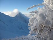
كرمنشاه مدينة إيرانية تقع غرب البلاد عاصمة محافظة كرمانشاه قرب الحدود مع العراق. located 525 kilometres (326 miles) from Tehran in the western part of Iran. According to the 2016 census, its population is 946,681 (2021 estimate 1,047,000).[1] A majority of the people of Kermanshah are bilingual in Southern Kurdish and Persian,[2] and the city is the largest Kurdish-speaking city in Iran.[3][4][5] Kermanshah has a moderate and mountainous climate.[6][7][8][9] Most of the inhabitants of Kermanshah are Shia Muslims, but there are also Sunni Muslims, Christians,[10] and followers of Yarsanism.[11][12]
. . . . . . . . . . . . . . . . . . . . . . . . . . . . . . . . . . . . . . . . . . . . . . . . . . . . . . . . . . . . . . . . . . . . . . . . . . . . . . . . . . . . . . . . . . . . . . . . . . . . . . . . . . . . . . . . . . . . . . . . . . . . . . . . . . . . . . . . . . . . . . . . . . . . . . . . . . . . . . . . . . . . . . . .
أصل الاسم
"Kermanshah" derives from the Sasanian-era title Kirmanshah, which translates as "King of Kerman".[13] Famously, this title was held by the son of Shapur III, Prince Bahram, who was bestowed with the title upon being appointed governor of the province of Kirman (present-day Kerman Province).[14][13] Later, in 390, when he had already succeeded his father as Bahram IV (ح. 388–399), he founded Kermanshah, and applied his former title to the new city, i.e. "(City of the) King of Kerman".[15][16]
After the revolution in 1979, the city was named Ghahramanshahr for a short period of time, and later the name of the city as well as the province changed to Bakhtaran, apparently due to the presence of the word "Shah" in the original name. Bakhtaran means western, which refers to the location of the city and the province within Iran. After the Iran–Iraq War, however, the city was renamed Kermanshah, as it resonated more with the desire of its residents, the Persian literature, and the collective memory of the Iranians.
التاريخ
| التعداد التاريخي | ||
|---|---|---|
| السنة | تعداد | ±% سنوياً |
| 1986 | 560٬514 | — |
| 1991 | 624٬084 | +2.17% |
| 1996 | 692٬986 | +2.12% |
| 2006 | 794٬863 | +1.38% |
| 2011 | 851٬405 | +1.38% |
| 2016 | 946٬651 | +2.14% |
| source:[17] | ||
Prehistory

Because of its antiquity, attractive landscapes, rich culture and Neolithic villages, Kermanshah is considered one of the cradles of prehistoric cultures. According to archaeological surveys and excavation, the Kermanshah area has been occupied by prehistoric people since the Lower Paleolithic period, and continued to later Paleolithic periods till late Pleistocene period. The Lower Paleolithic evidence consists of some handaxes found in the Gakia area to the east of the city. The Middle Paleolithic remains have been found in various parts of the province, especially in the northern vicinity of the city in Tang-e Kenesht, Tang-e Malaverd and near Taq-e Bostan.

Neanderthal Man existed in the Kermanshah region during this period and the only discovered skeletal remains of this early human in Iran was found in three caves and rockshelter situated in Kermanshah province.[18] The known Paleolithic caves in this area are Warwasi, Qobeh, Malaverd and Do-Ashkaft Cave. The region was also one of the first places in which human settlements including Asiab, Qazanchi, Sarab, Chia Jani, and Ganj-Darreh were established between 8,000 and 10,000 years ago.
_Tappeh_Sarab,_Kermanshah_ca._7000-6100_BCE_Neolithic_period,_National_Museum_of_Iran.jpg&filetimestamp=20220928040622&)
This is about the same time that the first potteries pertaining to Iran were made in Ganj-Darreh, near present-day Harsin. In May 2009, based on a research conducted by the university of Hamadan and UCL, the head of Archeology Research Center of Iran's Cultural Heritage and Tourism Organization announced that the one of the oldest prehistoric village in the Middle East dating back to 9800 B.P., was discovered in Sahneh, located west of Kermanshah.[19][20] Remains of later village occupations and early Bronze Age are found in a number of mound sites in the city itself.
The city contains 4 archaeological mound sites. These sites are Chogha Kaboud, Chogha Golan, Morad Hasel, and Tappa Gawri.
Sassanid Kermanshah

In ancient Iranian mythology, construction of the city is attributed to Tahmuras, the third king of Pishdadian dynasty. It is believed that the Sassanids have constructed Kermanshah and Bahram IV (he was called Kermanshah, meaning king of Kerman) gave his name to this city.[21] It was a glorious city in Sassanid period about the 4th century AD when it became the capital city of Persian Empire and a significant health center serving as the summer resort for Sassanid kings. In AD 226, following a two-year war led by the Persian Emperor, Ardashir I, against "Kurdish" tribes in the region, the empire reinstated a local "Kurdish" prince, Kayus of Medya, to rule Kermanshah.[بحاجة لمصدر] At the time, the term "Kurd" was used as a social term, designating Iranian nomads, rather than a concrete ethnic group.[22][23] The word became an ethnic identity in the 12th and 13th century.[24][25] Within the dynasty known as the House of Kayus (also Kâvusakân) remained a semi-independent kingdom lasting until AD 380 before Ardashir II removed the dynasty's last ruling member.[بحاجة لمصدر]
Islamic era
Kermanshah was conquered by the Arabs in AD 640. Under Seljuk rule in the eleventh century, it became the major cultural and commercial center in western Iran and the southern Kurdish-inhabited areas as a whole. The Safavids fortified the town, and the Qajars repulsed an attack by the Ottomans during Fath Ali Shah's rule (1797–1834). Kermanshah was occupied by Ottomans between 1723–1729 and 1731–1732.[بحاجة لمصدر]
Modern history
Occupied by the Imperial Russian army in 1914, followed by the Ottoman army in 1915 during World War I, it was evacuated in 1917 when the British forces arrived there to expel the Ottomans. Kermanshah played an important role in the Iranian Constitutional Revolution during the Qajar dynasty period and the Republic Movement in Pahlavi dynasty period. The city was harshly damaged during the Iran–Iraq War, and although it was rebuilt, it has not yet fully recovered.[بحاجة لمصدر]

المناخ
| متوسطات الطقس لكرمان شاه، إيران | |||||||||||||
|---|---|---|---|---|---|---|---|---|---|---|---|---|---|
| شهر | يناير | فبراير | مارس | أبريل | مايو | يونيو | يوليو | أغسطس | سبتمبر | اكتوبر | نوفمبر | ديسمبر | السنة |
| متوسط العظمى °م (°ف) | 2 (37) | 7 (45) | 13 (56) | 18 (66) | 25 (77) | 32 (90) | 36 (97) | 36 (97) | 31 (88) | 23 (75) | 15 (60) | 8 (47) | 21 (70) |
| متوسط الصغرى °م (°ف) | -3 (25) | -1 (29) | 3 (38) | 8 (47) | 12 (54) | 16 (62) | 22 (72) | 20 (69) | 16 (62) | 12 (54) | 5 (41) | 1 (34) | 10 (50) |
| هطول الأمطار cm (بوصة) | 6.5 (2.6) | 6.1 (2.4) | 8.6 (3.4) | 7 (2.8) | 3.6 (1.4) | 0.1 (0.1) | 0.1 (0.1) | 0.1 (0.1) | 0.1 (0.1) | 2.6 (1) | 5.1 (2.0) | 6.6 (2.6) | 48٫5 (18٫6) |
| المصدر: Weatherbase[26] April 2008 | |||||||||||||
| المصدر #2: Airport Weather Guide[27] April 2008 | |||||||||||||
. . . . . . . . . . . . . . . . . . . . . . . . . . . . . . . . . . . . . . . . . . . . . . . . . . . . . . . . . . . . . . . . . . . . . . . . . . . . . . . . . . . . . . . . . . . . . . . . . . . . . . . . . . . . . . . . . . . . . . . . . . . . . . . . . . . . . . . . . . . . . . . . . . . . . . . . . . . . . . . . . . . . . . . .
بهستون
| Bisotun | |
|---|---|
 | |
| أسس الاختيار | Cultural: ii, iii |
| المراجع | 1222 |
| Inscription | 2006 (30th Session) |
مسجد معاون الملك
هذا المسجد فريد على مستوى العالم لأن حيطانه تحمل صوراً من الشاهنامة، بالرغم من الصور للضخصيات الأكثر تديناً في الشاهنامة.
صور من كرمان شاه
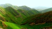
Mount Dalekhani 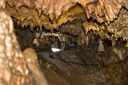
Ghouri Ghaleh Cave 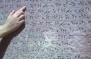
Close-Up of Bisotun Inscription ![Taghbostan Carving [fn 1]](/w/images/thumb/6/66/Harp-Sassanid.png/180px-Harp-Sassanid.png)
Taghbostan Carving [fn 1]


![Taghbostan Carving [fn 1]](/%D9%85%D9%84%D9%81:Harp-Sassanid.png)
_Tappeh_Sarab,_Kermanshah_ca._7000-6100_BCE_Neolithic_period,_National_Museum_of_Iran.jpg&filetimestamp=20220928040622)
البلدات التوأم - المدن الشقيقة
 روزبرگ، أوريگون، الولايات المتحدة
 صقلية، إيطاليا (2010)
 عينتاب، تركيا (2010)
 سپليت، كرواتيا (2011)
انظر أيضاً
- عطاء الله أشرفي اصفهاني
- قصف ملجأ منتزه كرمانشهاه
- Kalhor
- Visual Art High school of Kermanshah
- محافظة كرمان شاه
- كرمان شاهي
وصلات خارجية
- Pictures of Inscription and Bas relief of Darius the Great - Free Pictures of IRAN irantooth.com
- Photos from Bisotun Complex - From Online Photo Gallery Of Aryo.ir
- Photos from Taq-e Bostan - From Online Photo Gallery Of Aryo.ir
- Photos from Moavenol Molk Tekieh - From Online Photo Gallery Of Aryo.ir
المراجع
- ^ "Kermanshah, Iran Metro Area Population 1950-2021". www.macrotrends.net. Retrieved 2021-07-23.
- ^ Borjian, Habib (2017). "KERMANSHAH vii. LANGUAGES AND DIALECTS". In Yarshater, Ehsan (ed.). Encyclopædia Iranica, Volume XVI/3: Kégl–Kešaʾi Dialect. London and New York: Routledge & Kegan Paul. pp. 324–329. ISBN 978-1-934283-50-9.
- ^ "معاون امور عمرانی استانداری: کرمانشاه بزرگترین شهر کردنشین جهان است - ایرنا". شهرخبر. Retrieved 2019-05-29.
- ^ "کرمانشاه؛ پرجمعیت ترین شهر کردنشین ایران". خبرگزاری مهر | اخبار ایران و جهان | Mehr News Agency (in الفارسية). 2012-03-23. Retrieved 2019-05-29.
- ^ "اورمیا - بزرگترین شهر کردنشین جهان مشخص شد". Archived from the original on 2016-03-27. Retrieved 2016-03-18.
- ^ Iran Chamber society: accessed: September 2010.
- ^ روزنامه سلام کرمانشاه Archived 2010-06-21 at the Wayback Machine Persian (Kurdish)
- ^ آشنایی با فرهنگ و نژاد استان کرمانشاه Archived 2018-09-01 at the Wayback Machine(Persian)
- ^ سازمان میراث فرهنگی، صنایع دستی و گردشگری استان کرمانشاه[dead link] بازدید 2010/03/11
- ^ "Arrest of the Assyrian leader of the Kermanshah Church in iran". Assistnews.net. Archived from the original on 2011-09-29. Retrieved 2011-12-02.
- ^ RRT RESEARCH RESPONSE, Refugee Review Tribunal, www.justice.gov
- ^ "آشنایی با فرهنگ و نژاد استان کرمانشاه". www.artkermanshah.ir. Archived from the original on 2018-09-01. Retrieved 2019-05-29.
- ^ أ ب Kia, Mehrdad (2016). The Persian Empire: A Historical Encyclopedia [2 volumes]. ABC-CLIO. pp. 236–237. ISBN 978-1610693912.
- ^ Brunner, Christopher (1983). "Geographical and Administrative divisions: Settlements and Economy". The Cambridge History of Iran: The Seleucid, Parthian, and Sasanian periods (2). Cambridge: Cambridge University Press. p. 767. ISBN 978-0-521-24693-4.
- ^ Everett-Heath, John (2018). "Kermānshāh". The Concise Dictionary of World Place-Names (4 ed.). Oxford University Press. ISBN 978-0191866326.
- ^ قالب:ODLA
- ^ Iran: Provinces and Cities population statistics
- ^ "New study sheds light on second Neanderthal tooth found in western iran". Tehran Times - 29 August 2021. Tehran Times. Retrieved 5 November 2021.
- ^ "Most ancient Mid East village discovered in western Iran". 2009. Archived from the original on 2010-02-01. Retrieved 2009-05-23.
- ^ "با 11800 سال قدمت، قديميترين روستاي خاورميانه در كرمانشاه كشف شد". 2009. Retrieved 2009-05-23.[dead link]
- ^ Dehkhoda: Kermanshah Archived 2011-05-11 at the Wayback Machine.
- ^ J. Limbert. (1968). The Origins and Appearance of the Kurds in Pre-Islamic Iran. Iranian Studies, 1.2: pp. 41-51.
- ^ G. Asatrian. (2009). Prolegemona to the Study of Kurds. Iran and the Caucasus, 13.1: pp. 1-58.
- ^ James, Boris. (2006). Uses and Values of the Term Kurd in Arabic Medieval Literary Sources. Seminar at the American University of Beirut, pp. 6-7.
- ^ Martin van Bruinessen, "The ethnic identity of the Kurds," in: Ethnic groups in the Republic of Turkey, compiled and edited by Peter Alford Andrews with Rüdiger Benninghaus [=Beihefte zum Tübinger Atlas des Vorderen Orients, Reihe B, Nr.60]. Wiesbaden: Dr. Ludwich Reichert, 1989, pp. 613–21. excerpt: "The ethnic label "Kurd" is first encountered in Arabic sources from the first centuries of the Islamic era; it seemed to refer to a specific variety of pastoral nomadism, and possibly to a set of political units, rather than to a linguistic group: once or twice, "Arabic Kurds" are mentioned. By the 10th century, the term appears to denote nomadic and/or transhumant groups speaking an Iranian language and mainly inhabiting the mountainous areas to the South of Lake Van and Lake Urmia, with some offshoots in the Caucasus. ... If there was a Kurdish-speaking subjected peasantry at that time, the term was not yet used to include them."[1] Archived 2015-10-15 at the Wayback Machine
- ^ "Weatherbase: Historical Weather for Kermanshah, Iran". Weatherbase. 2007. Retrieved 2008-04-04.
- ^ "Kermanshah Airport Weather Guide". Airport Weather Guide. 2008. Retrieved 2008-04-04.
خطأ استشهاد: وسوم <ref> موجودة لمجموعة اسمها "fn"، ولكن لم يتم العثور على وسم <references group="fn"/>
- CS1 الفارسية-language sources (fa)
- Articles with dead external links from December 2017
- Articles with dead external links from September 2010
- Short description is different from Wikidata
- Articles with unsourced statements from February 2017
- Articles with unsourced statements from September 2019
- Pages using infobox UNESCO World Heritage Site with unknown parameters
- عواصم محافظات إيران
- الأسرة الساسانية
- مدن إيران