جزيرة هونگ كونگ
香港島 | |
|---|---|
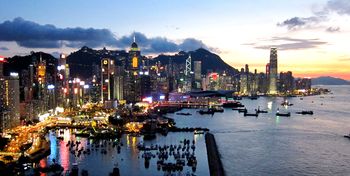 جزيرة هونگ كونگ كما تبدو من نورث پوينت، أغسطس 2011. | |
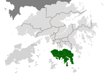 موقع الجزيرة في هونگ كونگ (بالأخضر) | |
| الجغرافيا | |
| الإحداثيات | 22°15′52″N 114°11′14″E / 22.26444°N 114.18722°ECoordinates: 22°15′52″N 114°11′14″E / 22.26444°N 114.18722°E |
| المساحة | 78.59 km2 (30.34 sq mi) |
| أعلى منسوب | 552 m (1٬811 ft) |
| أعلى نقطة | قمة ڤيكتوريا |
| السكان | |
| التعداد | 1.270.876 (2011) |
| الكثافة السكانية | 16٫390 /km2 (42٫45 /sq mi) |
| الجماعات العرقية | 88.5%، صينيون، 4% فلپينيون، 2.4% إندونيسيون، 2.4% بيض |
| جزيرة هونگ كونگ | |||||||||||||||||||||||||||
|---|---|---|---|---|---|---|---|---|---|---|---|---|---|---|---|---|---|---|---|---|---|---|---|---|---|---|---|
| الصينية التقليدية | 香港島 | ||||||||||||||||||||||||||
| الصينية المبسطة | 香港岛 | ||||||||||||||||||||||||||
| Jyutping | Hoeng1gong2 dou2 | ||||||||||||||||||||||||||
| |||||||||||||||||||||||||||
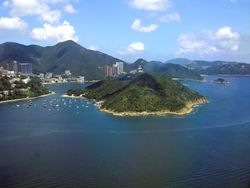
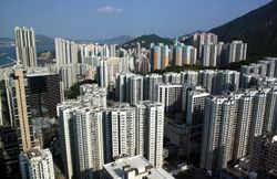
جزيرة هونگ كونگ (صينية: 香港島؛ كانتونية يل: Hēunggóng dóu�)، هي جزيرة في المنطقة الجنوبية من هونگ كونگ. يبلغ عدد سكانها 1.289.500 نسمة وتصل كثافتها السكانية إلى 16.390/كم²،[1] اعتباراً من 2008 كان عدد سكان الجزيرة حوالي 3.000 نسمة ينتشرون في عشرات من قرى الصيد عندما احتلتها المملكة المتحدة لبريطانيا العظمى وأيرلندا في حرب الأفيون الأولى (1839-1842). عام 1842، تم التنازل عن الجزيرة رسمياً إلى الأبد للملكة المتحدة بموجب معاهدة نانكنگ ثم أسست القوات البريطانية مدينة ڤيكتوريا على الجزيرة تكريماً للملكة ڤيكتوريا.
المنطقة الوسطى في الجزيرة هي المركز التاريخي والسياسي والاقتصادي لهونگ كونگ. يشكل الساحل الشمالي للجزيرة الساحل الجنوبي لميناء ڤيكتوريا، المسئول بشكل كبير عن تنمية هونگ كونگ نظراً لمياهه العميقة المفضلة للسفن التجارية الضخمة.
تضم الجزيرة الكثير من المعالم السياحية الشهيرة في هونگ كونگ، مثل "قمة ڤيكتورياالقمة"، أوشن پارك، والكثير من المواقع التاريخية ومراكز التسوق الضخمة. تعتبر السلاسل الجبلية في الجزيرة وجهة شهيرة لتسلق الجبال.
تشكل المنطقة الشمالية من جزيرة هونگ كونگ، مع كاولون وبلدة تسون وان الجديدة المنطقة الحضرية المركزية في هونگ كونگ. تبلغ مساحتهما مجتمعتين 88.3 كم² ويصل عدد سكانهما (المنطقة الشمالية من الجزيرة وكاولون) حوالي 3.156.500 نسمة، أي بكثافة سكانية تبلغ 35.700 كم².
عادة ما يشار للجزيرة بالاسم المحلي "جانب هونگ كونگ" أو "جانب الجزيرة". طُبق هذا الأسلوب على الكثير من المواقع (على سبيل المثال جانب الصين، أو حتى جانب مدينة كاولون المسورة) لكنه يستخدم الآن فقط بهذا الشكل وكاولون ومقترح استخدامها على جانبي الميناء.[2] كان هذا الأسلوب شائعاً في الماضي في بريطانيا أكثر من الآن، مثل جانب-سري[3] ولا زال مستخدماً في أسماء الأماكن البريطانية مثل تشيپسايد، تاينسايد، وتيزسايد، وليس لكل منها مجاري مائية أو حدود واضحة بجوانب فعلية.
. . . . . . . . . . . . . . . . . . . . . . . . . . . . . . . . . . . . . . . . . . . . . . . . . . . . . . . . . . . . . . . . . . . . . . . . . . . . . . . . . . . . . . . . . . . . . . . . . . . . . . . . . . . . . . . . . . . . . . . . . . . . . . . . . . . . . . . . . . . . . . . . . . . . . . . . . . . . . . . . . . . . . . . .
الضواحي والمحليات
تتألف جزيرة هونگ كونگ من الضواحي/المحليات التالية:
- أبردين
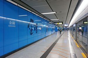
- أدميرالتي
- آپ لي تشاو
- خليج كوزواي
- سنترال/تشونگ وان
- تشاي وان
- سابرپورت
- خليج ديپ واتر
- إيست-ميد ليڤلز
- فورترس هل
- هاپي ڤالي
- كندي تاون
- ميد-ليڤلز
- ماونت ديڤز
- نورث پوينت
- پوك فو لام
- هليج كواري
- خليج ريپلس
- ساي وان هو
- ساي وان
- ساي يينگ پون
- خليج ساندي
- شاو كي وان
- شك أو
- شك تونگ تسوي
- شونگ وان
- سيو ساي وان
- سو كون پو
- ستانلي
- تاي هانگ
- تاي تام
- تين هاو
- ڤيكتوريا پارك
- قمة ڤيكتوريا
- وان تشاي
- وست ميد ليڤلز
- وونگ تشوك هانگ
الادارة
جزيرة هونگ كونگ ليست جزءاً من مقاطعة الجزر. تقع مقاطعات هونگ كونگ الأربعة على الجزيرة:
- المقاطعة الوسطى والغربية
- المقاطعة الشرقية
- المقاطعة الجنوبية (تشمل جزيرتي أپ لي تشاو وأپ لي پاي)
- مقاطعة وان تشاي
التاريخ
Human settlement of the area dates back millennia, as evidenced by Neolithic artifacts discovered in Stanley, Hong Kong Island. Qin Shihuang's (秦始皇) imperial government settled Baiyue, and today Hong Kong Island was under the jurisdiction of Panyu County (番禺縣) in Nanhai County (南海郡), to the Western Jin Dynasty. After the sixth year of the Eastern Jin Dynasty (a.d. 331), it belonged to Baoan County (寶安縣)). According to the "Hong Kong Island East Region Winds", the Hong Kong Yacht Club (formerly known as Lantern Island, also known as Kellett Island) (the entrance to the Hong Kong Island at the Cross Harbour Tunnel today) has unearthed the copper coins from the Sui and Tang Dynasties to the Song Dynasty. It is estimated that at during the Sui and Tang Dynasties, the island already had commercial activity. In the first year of the Wanli Period of the Ming Dynasty (1573), it was the territory of Xin'an County, and remained so until it was ceded to the United Kingdom.(source of information: https://www.amo.gov.hk/en/archaeology_work.php)
المستعمرة البريطانية
Following the First Opium War (1839-1842), Hong Kong Island was ceded to Britain in 1842 under the Treaty of Nanking and the territory became a Crown colony.[7] At the time, the island was populated by only a few thousand people, and was thus described as being almost uninhabited.
الغزو والاحتلال الياباني
The Second World War was a dark period for Hong Kong. In the 1930s, the British anticipated a Japanese attack on Hong Kong. As Wong Nai Chung Gap was a strategic important place of defence, large-scale defensive works were constructed there, including anti-aircraft batteries, howitzers, and machine gun nests.
The Battle of Hong Kong began on 8 December 1941. British, Canadian, Indian armies and the Hong Kong Volunteer Defence Forces resisted the Japanese invasion commanded by Sakai Takashi, which began eight hours after the attack on Pearl Harbor. However, the Japanese were able to take control of the Hong Kong skies on the first day of attack, outnumbering the defenders. The defenders retreated from the Gin Drinker's Line and consequently from Kowloon under heavy aerial bombardment and artillery barrage.
الجغرافيا
Hong Kong Island is the second-largest island of the territory, the largest being Lantau Island. Its area is 78.59 km2 (30.34 sq mi), including 6.98 km2 (2.69 sq mi) of land reclaimed since 1887 and some smaller scale ones since 1851. It makes up approximately 7% of the total territory. It is separated from the mainland (Kowloon Peninsula and New Territories) by Victoria Harbour.
Most of the hills across the middle of the island are included within the country parks.
الديموغرافيا
The population اعتبارا من 2011[تحديث] is 1,270,876, which makes up approximately 19% of that of Hong Kong. Its population density is higher than for the whole of Hong Kong, ca. 18,000 per km². However, the population is heavily concentrated along the northern shore. The combined population of Central and Western, Wan Chai, and Eastern is 1,085,500, giving this urbanised part of the island a density of around 26,000 per km², or 67,000 per mi², in its approximately 41.3 km2 (15.9 sq mi).
The residents living in the Central and Western and Wanchai districts of Hong Kong island have the highest median household income of any area in Hong Kong. Affluent districts on Hong Kong Island are The Peak, Western Mid-Levels (Conduit Road/Robinson Road/Magazine Gap Road/Kotewall Road etc.), Eastern Mid-Levels (Happy Valley/Tai Hang/Jardine's Lookout), Tai Tam, Deep Water Bay and Repulse Bay.
88.5% of Hong Kong Island's residents are of Chinese descent. The largest ethnic minority groups are Filipinos (4%), Indonesians (2.4%), and White people (2.4%).[4]
80.2% of Hong Kong Island's residents use Cantonese as their usual language, while 8% use English and 1.9% use Mandarin.[4]
النقل
انظر أيضاً
- هونگ كونگ
- قائمة مناطق هونگ كونگ
- قائمة شوارع وطرق هونگ كونگ
- جزر وأشباه جزر هونگ كونگ
- المنتزهات الحكومية والحفاظ في هونگ كونگ
- طريق الملكة
- طريق دي ڤو
- طريق كانوت
المصادر
- ^ Census and Statistics Department (2008), Population and Vital Events, Archived from the original on 24 August 2009, https://web.archive.org/web/20090824065021/http://www.statistics.gov.hk/publication/feature_article/B70906FC2009XXXXB0100.pdf, retrieved on 31 August 2009
- ^ Booth, Martin. Gweilo: A memoir of a Hong Kong childhood, Bantam Books, 2005. ISBN 0-553-81672-1, pp108, 173
- ^ The Professor and the Madman, Simon Winchester, Harper, ISBN 978-0-06-083978-9, p8,
- ^ أ ب District Profiles, Hong Kong Census, 2011, http://www.census2011.gov.hk/en/district-profiles.html, retrieved on 27 September 2013

