اتفاقية پوليه-نيوكومب
اتفاقية پوليه-نيوكومب Paulet–Newcombe Agreement أو خط پوليه-نيوكومب Paulet-Newcombe Line، تعرف أيضاً باتفاقيات الحدود الفرنسية-البريطانية، هي سلسلة من الاتفاقية الموقعة عام 1920-23 بين الحكومتين البريطانية والفرنسية حول موقف وطبيع الحدود بين الانتداب على فلسطين والعراق، الممنوح لبريطانيا، والانتداب على سوريا ولبنان الممنوح لفرنسا. حددت الاتفاقيات خط الحدود السورية الفلسطينية (الحدود الإسرائيلية-السورية حالياً) بين البحر المتوسط وبلدة الحمة.[1] سميت الاتفاقية على اسم الكولونيل الفرنسي ن. پوليه والكولونيل البريطاني ستوارت فرانسس نيوكومب، اللذان تم تعيينهما لرئاسة لجنة الحدود.[2]
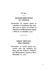
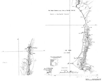
الحدود بين الانتدابين البريطاني والفرنسي المقبلين كانا قد رُسما بعبارات عامة في "الاتفاقية الفرنسية-البريطانية حول بعض النقاط المتصلة بالانتداب على سوريا ولبنان، فلسطين، والعراق"، الموقعة في پاريس، في 23 ديسمبر 1920.[3][4] وضعت هذه الاتفاقية جزء كبير من مرتفعات الجولان في منطقة الانتداب الفرنسي. وتأسست بموجب هذه الاتفاقية أيضاً لجنة مشتركة لتسوية التفاصيل الحدودية الدقيقة ووضع علامات حدودية على الأرض.[3]
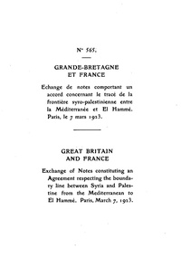
قدمت اللجنة تقريرها النهائي في 3 فبراير 1922، والذي تضمن عدد من التعديلات. تم التصديق عليها وعلى بعض المذكرات القانونية من قبل الحكومتين البريطانية والفرنسية في 7 مارس 1923، قبل بضعة شهور من تولي بريطانيا وفرنسا مسئوليات الانتداب في 29 سبتمبر 1923.[1][5]
Today's Iraq–Syria border, Jordan–Syria border and Israel-Lebanon border, apart from the areas disputed as a result of Israel's conflicts with Lebanon and Syria, are defined by these agreements.[6][7][8]
. . . . . . . . . . . . . . . . . . . . . . . . . . . . . . . . . . . . . . . . . . . . . . . . . . . . . . . . . . . . . . . . . . . . . . . . . . . . . . . . . . . . . . . . . . . . . . . . . . . . . . . . . . . . . . . . . . . . . . . . . . . . . . . . . . . . . . . . . . . . . . . . . . . . . . . . . . . . . . . . . . . . . . . .
سايكس-پيكو والحرب الفرنسية السورية

The line separating the British and French spheres of interest in the area was first defined in the 1916 Sykes-Picot agreement. Britain's military occupied the region during the First World War, and in 1920 the French army invaded Syria. On 8 August 1920, during the Transjordan interregnum period, the French confirmed to the British that they would respect the Sykes-Picot line, and not move any military forces south.[9]
اتفاقية ديسمبر 1920

The boundary between the forthcoming British and French mandates was first defined in broad terms in the 1920 "Franco-British Convention on Certain Points Connected with the Mandates for Syria and the Lebanon, Palestine and Mesopotamia", signed in Paris by the British Ambassador to France, Charles Hardinge and the French Foreign Minister, Georges Leygues, on 23 December 1920.[3][4] That agreement placed the bulk of the Golan Heights in the French sphere.
The treaty also established a joint commission to settle the precise details of the border and mark it on the ground.[3]
The 1932 commission concluded that the 1920 agreement had been reached on the basis of the “British International 1:1,000,000 map published in 1916 and revised in 1918”, formally known as the Asia 1: 1,000,000. Projection of the International Map compiled at the Royal Geographical Society under the direction of the Geographical Section, General Staff. Drawn and printed at the War Office, 1916, today known as "GSGS 2555".[10]
The boundaries between the territories under the French mandate for Syria and the Lebanon on the one hand and the British mandates of Mesopotamia and Palestine on the other are determined as follows:On the east, the Tigris from Jeziret-ibn-Omar to the boundaries of the former vilayets of Diarbekir and Mosul.
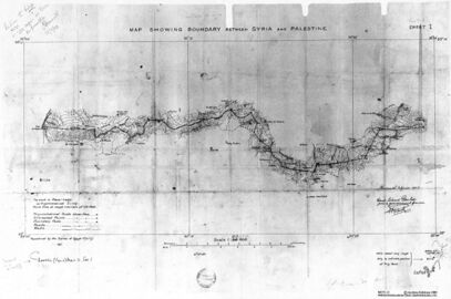
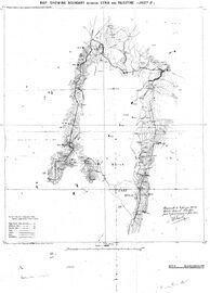
On the south-east and south, the aforesaid boundary of the former vilayets southwards as far as Roumelan Koeui; thence a line leaving in the territory under the French mandate the entire basin of the western Kabur and passing in a straight line towards the Euphrates, which it crosses at Abu Kemal, thence a straight line to Imtar to the south of Jebul Druse, then a line to the south of Nasib on the Hedjaz Railway, then a line to Semakh on the Lake of Tiberias, traced to the south of the railway, which descends towards the lake and parallel to the railway. Deraa and its environs will remain in the territory under the French mandate; the frontier will in principle leave the valley of the Yarmuk in the territory under the French mandate, but will be drawn as close as possible to the railway in such a manner as to allow the construction in the valley of the Yarmuk of a railway entirely situated in the territory under the British mandate. At Semakh the frontier will be fixed in such a manner as to allow each of the two High Contracting Parties to construct and establish a harbour and railway station giving free access to the Lake of Tiberias.
On the west, the frontier will pass from Semakh across the Lake of Tiberias to the mouth of the Wadi Massadyie. It will then follow the course of this river upstream, and then the Wadi Jeraba to its source. From that point it will reach the track from El Kuneitra to Banias at the point marked Skek, thence it will follow the said track, which will remain in the territory under the French mandate as far as Banias. Thence the frontier will be drawn westwards as far as Metullah, which will remain in Palestinian territory. This portion of the frontier will be traced in detail in such a manner as to ensure for the territory under the French mandate easy communication entirely within such territory with the regions of Tyre and Sidon, as well as continuity of road communication to the west and to the east of Banias.
From Metullah the frontier will reach the watershed of the valley of the Jordan and the basin of the Litani. Thence it will follow this watershed southwards. Thereafter it will follow in principle the watershed between the Wadis Farah-Houroun and Kerkera, which will remain in the territory under the British mandate, and the Wadis El Doubleh, El Aioun and Es Zerka, which will remain in the territory under the French mandate. The frontier will reach the Mediterranean Sea at the port of Ras-el-Nakura, which will remain in the territory under the French mandate.
— Franco-British Convention on Certain Points Connected with the Mandates for Syria and the Lebanon, Palestine and Mesopotamia, 23 December 1920, Article I
اتفاقية مارس 1923

The commission submitted its final report on 3 February 1922, which included a number of amendments. The amendments included:[11]
- North East boundary moved westward (reducing the area of Palestine) to avoid splitting أراضي الأمير محمود الفاعور من القنيطرة[11]
- Northern boundary moved northward (increasing the area of Palestine) to include the entire Sea of Galilee and the Yarmuk valley[11]
It was approved with some caveats by the French and British governments on 7 March 1923, several months before Britain and France assumed their Mandatory responsibilities on 29 September 1923.[1][5]
The agreements fixed the line of the Syrian-Palestinian border (now the Syrian-Israeli border) between the Mediterranean Sea and the town of Al-Hamma.[1] The 1923 agreement takes its name from French Lieutenant Colonel N. Paulet and British Lieutenant Colonel S. F. Newcombe, who was appointed to lead the Boundary Commission.[12]
مفوضية الحدود العراقية-السورية 1932
The League of Nations appointed a commission to review the Iraq-Syria border, ahead of the October 1932 accession of Iraq to the League of Nations.[10] The commission carried out a detailed review of the 1920 agreement.[10]
معرض صور
- اتفاقية پوليه-نيوكومب


انظر أيضاً
الهوامش

- ^ أ ب ت ث Agreement between His Majesty's Government and the French Government respecting the Boundary Line between Syria and Palestine from the Mediterranean to El Hámmé, Treaty Series No. 13 (1923), Cmd. 1910. Also Louis, 1969, p. 90. خطأ استشهاد: وسم
<ref>غير صالح؛ الاسم "1923A" معرف أكثر من مرة بمحتويات مختلفة. - ^ The Seven Villages: Origins and Implication, Nicholas Blanford
- ^ أ ب ت ث Text available in American Journal of International Law, Vol. 16, No. 3, 1922, 122–126.
- ^ أ ب Text available in Carnegie Endowment for International Peace, American Association for International Conciliation (1920). International conciliation, Volume 146; Volume 169. American Branch of the Association for International Conciliation. pp. 297–303. خطأ استشهاد: وسم
<ref>غير صالح؛ الاسم "FRANCO-BRITISH CONVENTION" معرف أكثر من مرة بمحتويات مختلفة. - ^ أ ب FSU Law. خطأ استشهاد: وسم
<ref>غير صالح؛ الاسم "FSU Law" معرف أكثر من مرة بمحتويات مختلفة. - ^ International Boundary Study, No. 100 – May 15, 1970, Iraq – Syria Boundary: "The boundary as it is today is based on the League of Nations Report of the Commission entrusted by the Council with the study of the Frontier between Syria and Iraq, Geneva, September 10, 1932."
- ^ V. M. Amadouny (1995). "The Formation of the Transjordan-Syria Boundary, 1915-32". Middle Eastern Studies. Taylor & Francis, Ltd. 31 (3): 533–549. doi:10.1080/00263209508701068. JSTOR 4283741.
- ^ Kakish, Daniel Moneef (2014). [URI: http://hdl.handle.net/10211.3/115511 The Invention of the Transjordanian-Syrian Border: 1915-1932] (Thesis).
{{cite thesis}}: Check|url=value (help) - ^ Paris, Timothy J. (23 November 2004). Britain, the Hashemites and Arab Rule: The Sherifian Solution. Routledge. p. 154. ISBN 978-1-135-77191-1.
Not until 8 August did the French assure Curzon they had no intention of moving south of the Sykes-Picot line, which ran east-west on a line just south of Dir'a.
- ^ أ ب ت League of Nations, Report of the Commission entrusted by the Council with the Study of the Frontier between Syria and Iraq, C. 578. M. 285. 1932. VI, Geneva, September 10th, 1932
- ^ أ ب ت Biger 2004, p. 147-8.
- ^ The Seven Villages: Origins and Implication, Nicholas Blanford
المراجع
- Franco-British Convention on Certain Points Connected with the Mandates for Syria and the Lebanon, Palestine and Mesopotamia, signed Dec. 23, 1920. Text available in American Journal of International Law, Vol. 16, No. 3, 1922, 122-126.
- Agreement between His Majesty's Government and the French Government respecting the Boundary Line between Syria and Palestine from the Mediterranean to El Hámmé, Treaty Series No. 13 (1923), Cmd. 1910.
- Gideon Biger (1989), Geographical and other arguments in delimitation in the boundaries of British Palestine, in "International Boundaries and Boundary Conflict Resolution", IBRU Conference, ISBN 1-85560-000-5, 41-61.
- John McTague (1982), Anglo-French Negotiations over the Boundaries of Palestine, 1919-1920, Journal of Palestine Studies, Vol. 11, No. 2, 101-112.
- Yitzhak Gil-Har (1993), British commitments to the Arabs and their application to the Palestine-Trans-Jordan boundary: The issue of the Semakh triangle, Middle Eastern Studies, Vol.29, No.4, 690-701.
- Muhsin Yusuf (1991), The Zionists and the process of defining the borders of Palestine, 1915-1923, Journal of South Asian and Middle Eastern Studies, Vol. 15, No. 1, 18-39.
- Gideon Biger (1995), The encyclopedia of international boundaries, New York : Facts on File.
- Gideon Biger (2005), The Boundaries of Modern Palestine, 1840-1947. London: Routledge. ISBN 0-7146-5654-2.
- US Department of State, International Boundary Study series: Iraq-Jordan, Iraq-Syria, Jordan-Syria, Israel-Lebanon.
| ع1910 |  | |
|---|---|---|
| ع1920 |
| |
| ع1930 | ||
| ع1940 | ||
- CS1 errors: URL
- Short description is different from Wikidata
- معاهدات 1923
- عقد 1920 في المملكة المتحدة
- معاهدات المملكة المتحدة (1801–1922)
- العلاقات البريطانية الفرنسية
- تاريخ لبنان
- تاريخ سوريا
- تاريخ إسرائيل
- تاريخ فلسطين
- حدود لبنان
- حدود إسرائيل
- حدود فلسطين
- حدود سوريا
- 1920 في العراق
- 1920 في سوريا
- 1920 في فلسطين
- 1923 في العراق
- 1923 في سوريا
- 1923 في فلسطين
- معاهدات حدود
- معاهدات فترة بين الحربين
- معاهدات أبرمت في 1920
- معاهدات أبرمت في 1923
- معاهدات الجمهورية الفرنسية الثالثة
- معاهدات مددت إلى فلسطين تحت الانتداب
- متعلقة بالمكتبة الرقمية العالمية
- معاهدات مددت إلى العراق تحت الانتداب
- معاهدات مددت إلى الانتداب الفرنسي على سوريا ولبنان
- وثائق الانتداب البريطاني على فلسطين