محافظة الازيغ
محافظة إلازيغ
Elazığ ili | |
|---|---|
 جامع عزت پاشا في وسط مدينة إلازيغ | |
 Location of Elazığ Province in Turkey | |
 مقاطعات محافظة إلازيغ | |
| البلد | تركيا |
| المنطقة | وسط شرق الأناضول |
| أكبر مدينة | إلازيغ |
| الحكومة | |
| • الدائرة الانتخابية | إلازيغ |
| • الوالي | Ömer Toraman[1] |
| المساحة | |
| • الإجمالي | 9٬383 كم² (3٬623 ميل²) |
| التعداد (2022)[2] | |
| • الإجمالي | 591٬497 |
| • الكثافة | 63/km2 (160/sq mi) |
| مفتاح الهاتف | 00424 |
| ISO 3166 code | TR-23 |
| لوحة السيارة | 23 |
| الموقع الإلكتروني | www.elazig.gov.tr |
محافظة إلازيغ أو معمورة العزيز (تركية: Elazığ ili; Zazaki: Suke Xarpêt;[3] كردي: Parêzgeha Xarpêtê[4])، هي إحدى محافظات تركيا. عاصمتها مدينة معمورة العزيز تبلغ مساحتها 8,455 كم²، منها 826 كم² مغطاة بالبحيرات والخزانات المائية.[5][6] ويبلغ عدد سكانها 569,616 نسمة، في 2000، كما يبلغ معدل الكثافة السكانية 62 نسمة/كم². المحافظة تُعتبر جزءاً من كردستان التركية وتسكنها أغلبية كردية،[7][8] مع أقلية معتبرة من الأتراك.
اسمها الأرمني خرپوت، ثم سميت "مزرعة" التي سميت معمورة العزيز في العهد العثماني ثم تم تتريك الاسم إلى إلازيغ بعد 1936.
سكانها من الكرد. هناك المئات من العوائل والأسر التي تقطن سوريا ومصر وبلدان أخرى تنتسب لهذه البلدة الكردية منهم آل الخربوطلي وآل ظاظا حيث كانوا يشكلون فرق عسكرية خاصة ضمن الجيش العثماني أو المصري وبرز منهم من عمل في الشرطة أو التجارة.
. . . . . . . . . . . . . . . . . . . . . . . . . . . . . . . . . . . . . . . . . . . . . . . . . . . . . . . . . . . . . . . . . . . . . . . . . . . . . . . . . . . . . . . . . . . . . . . . . . . . . . . . . . . . . . . . . . . . . . . . . . . . . . . . . . . . . . . . . . . . . . . . . . . . . . . . . . . . . . . . . . . . . . . .
التاريخ
في 1927 أنشئ مكتب المفتش العمومي، الذي حكم بقانون الطوارئ.[9] The province was included in the first Inspectorate General (Umumi Müfettişlik, UM) over which the Inspector General ruled. The UM span over the provinces of Hakkâri, Siirt, Van, Mardin, Bitlis, Şanlıurfa, Elazığ and Diyarbakır.[10]
في ديسمبر 1935، مُرّر قانون تونجلي، الذي which demanded a more powerful Government in the region.[11] In January 1936 the Elazığ Province was transferred under the authority of the newly established Fourth Inspectorate General, which span over the provinces of Elazığ, Erzincan, Bingöl and Tunceli[12] and its seat was في مدينة إلازيغ.[13] The fourth UM was governed by a Governor-Commander. Most of the employees in the municipalities had to be from the military and the Governor-Commander had the authority to evacuate whole villages and resettle them in another part of the province.[14] In 1946 the Tunceli Law was abolished and the state of emergency removed but the authority of the fourth UM was transferred to the military.[14]
تم حل المفتشيات العمومية في 1952 في عهد حكومة الحزب الديمقراطي.[15]
The province has experienced many earthquakes, including a magnitude 6.1 earthquake on 8 March 2010 and a magnitude 6.7 earthquake on 24 January 2020.[16]
الجغرافيا
تمتد إلازيغ، عموماً، باتجاه من الغرب-جنوب غرب إلى الشرق-شمال شرق، بحذى خط تتساوى عليه نقاط الطول والعرض. منبع نهر الفرات يوجد في هذه المحافظة.
المقاطعات

تنقسم محافظة الازيغ إلى 11 مقاطعة (المقاطعة العاصمة بالخط العريض):
الاقتصاد
Historically, Elazığ Province produced silver, which ceased being mined in 1885. The Turkish government attempted to modernize the mines; however, the cost of fuel and energy caused the shut down. There was a silver mine still producing in 1903 in Palu, as with coal. Coal is also found in other areas of the province. Gold and salt was also produced.[17]
التعليم
Education is provided by the Elazığ Provincial Directorate for National Education. It currently views over 442 educational institutions, both formal and informal ones.[18]
الآثار
Altınova, Elazığ was an important archaeological site in the Altınova plain that was excavated in the 1970s. It was later flooded by the Keban Dam. Other sites in the Altınova plain were also Tepecik, Korucutepe, Değirmentepe, and Körtepe.
معرض الصور
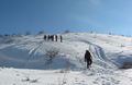
مركز تزلج حاضربابا
المشهد من بلدة قرة قوچان
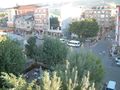
مشهد من مدينة الازيغ
Elazığ Train Station
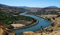
Palu and the Murat river
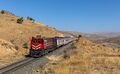
DE 24 184 of TCDD (Türkiye Cumhuriyeti Devlet Demiryollari) at Pınarlı, Turkey.
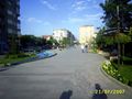
Culture Park

City view at night

Doğukent Stadium
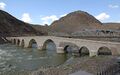
Stone Bridge, Palu


المصادر
- ^ "Elazığ Valisi Dr. Omer TORAMAN". www.elazig.gov.tr. Archived from the original on 2021-10-07. Retrieved 2020-04-08.
- ^ "The Results of Address Based Population Registration System, 2022, Statistical Tables, Population of Provinces by Years" (XLS) (in الإنجليزية). TÜİK. Retrieved 15 September 2023.
- ^ Zazaca -Türkçe Sözlük, R. Hayıg-B. Werner
- ^ "Li Wanê taxek hat kerentînekirin" (in الكردية). Rûdaw. 8 April 2020. Retrieved 27 April 2020.
- ^ "Elazığ Province". Encyclopaedia of Islam (2 ed.). BRILL: 167. 2002. ISBN 9789004161214.
- ^ Mutlu, Servet (1996). "Ethnic Kurds in Turkey: A Demographic Study". International Journal of Middle East Studies. 28 (4): 526. doi:10.1017/S0020743800063819. ISSN 0020-7438. JSTOR 176151. S2CID 154212694 – via JSTOR.
- ^ "Kurds, Kurdistān". Encyclopaedia of Islam (2 ed.). BRILL. 2002. ISBN 9789004161214.
- ^ Gunes, Cengiz (2020-11-26). The Political Representation of Kurds in Turkey: New Actors and Modes of Participation in a Changing Society (in الإنجليزية). Bloomsbury Publishing. ISBN 978-0-7556-0634-4.
- ^ Jongerden, Joost (1 January 2007). The Settlement Issue in Turkey and the Kurds: An Analysis of Spatical Policies, Modernity and War (in الإنجليزية). BRILL. p. 53. ISBN 978-90-04-15557-2.
- ^ Bayir, Derya (2016-04-22). Minorities and Nationalism in Turkish Law (in الإنجليزية). Routledge. p. 139. ISBN 978-1-317-09579-8.
- ^ Cagaptay, Soner (2 May 2006). Islam, Secularism and Nationalism in Modern Turkey: Who is a Turk? (in الإنجليزية). Routledge. pp. 108–110. ISBN 978-1-134-17448-5.
- ^ Cagaptay (2006), p.110
- ^ Soner Çaǧaptay, Islam, Secularism, and Nationalism in Modern Turkey: Who is a Turk?, Taylor & Francis, 2006, ISBN 978-0-415-38458-2, p. 48
- ^ أ ب Bayir, Derya (2016-04-22). Minorities and Nationalism in Turkish Law (in الإنجليزية). Routledge. pp. 139–141. ISBN 978-1-317-09579-8.
- ^ Fleet, Kate; Kunt, I. Metin; Kasaba, Reşat; Faroqhi, Suraiya (2008-04-17). The Cambridge History of Turkey (in الإنجليزية). Cambridge University Press. p. 343. ISBN 978-0-521-62096-3.
- ^ "M 6.7 - 13km N of Doganyol, Turkey". earthquake.usgs.gov. Retrieved 2020-04-01.
- ^ Prothero, W.G. (1920). Armenia and Kurdistan. London: H.M. Stationery Office. p. 74.
- ^ Solmaz, Remzi (2015-12-14). "Elazig City Department Of Education". EPALE - European Commission (in الإنجليزية). Retrieved 2020-05-23.
وصلات خارجية
| Elazığ Province
]].- (لغة تركية) Elâzığ governor's official website
- (لغة تركية) Elâzığ municipality's official website
- (إنگليزية) Elâzığ weather forecast information
Coordinates: 38°40′03″N 39°21′35″E / 38.66750°N 39.35972°E
| الأقضية الحضرية | | |
|---|---|---|
| الأقضية الريفية | ||
المناطق | ||
| إيجه | ||
| البحر الأسود | ||
| وسط الأناضول | ||
| شرق الأناضول | ||
| مرمرة | ||
| البحر المتوسط | ||
| جنوب شرق الأناضول | ||