المرية
المرية
Almería | |
|---|---|
 | |
 Flag  Seal | |
 المرية  المرية | |
| الإحداثيات: 36°50′N 2°27′W / 36.833°N 2.450°W | |
| البلد | |
| الإقليم | |
| البلدية | المرية |
| الحكومة | |
| • العمدة | Luis Rogelio Rodríguez-Comendador Pérez (PP) |
| المساحة | |
| • الإجمالي | 295 كم² (113٫9 ميل²) |
| المنسوب | 23 m (76 ft) |
| التعداد (2007) | |
| • الإجمالي | 189٬798 |
| • الكثافة | 615٫9/km2 (1٬595٫3/sq mi) |
| منطقة التوقيت | UTC+1 (CET) |
| • الصيف (التوقيت الصيفي) | UTC+2 (CEST) |
المرية (Almería ؛ UK /ˌælməˈriːə/،[1] also الأمريكي /ˌɑːlʔ/،[2][3] النطق الإسپاني: [almeˈɾi.a]) هي مدينة في إقليم أندلوسيا، اسبانيا، تقع في جنوب شرق اسبانيا على البحر المتوسط، وهي عاصمة مقاطعة بنفس الاسم. أسس عبد الرحمن الثالث القصبة (القلعة)، التي أعطت المدينة اسمها: المريّة، "برج المراقبة").[4] وفي القرنين العاشر والحادي عشر، شكلت جزءاً من خلافة قرطبة، واغتنت من التجارة وصناعة المنسوجات، خصوصاً حرير المرية. إلا أنها عانت العديد من الحصارات وسقطت تحت سيطرة المسيحيين في 1489. وفي 1522، دمر المرية زلزال كبير، ولم يبدأ إعادة البناء والتعافي حتى القرن التاسع عشر. وأثناء الحرب الأهلية الاسبانية، قـُصِفت المدينة من قِبل البحرية الألمانية وسقطت في يد فرانكو في 1939. ومنذ ذلك الحين أعيد بناء اقتصادها حول انتاج الخضروات، بنحو 100,000 فدان من الصوب، يمد معظم أوروپا.[بحاجة لمصدر]
. . . . . . . . . . . . . . . . . . . . . . . . . . . . . . . . . . . . . . . . . . . . . . . . . . . . . . . . . . . . . . . . . . . . . . . . . . . . . . . . . . . . . . . . . . . . . . . . . . . . . . . . . . . . . . . . . . . . . . . . . . . . . . . . . . . . . . . . . . . . . . . . . . . . . . . . . . . . . . . . . . . . . . . .
التاريخ
المرية مدينة حديثة النشأة نسبيا مقارنة بباقي مدن الأندلس أمر ببنائها الخليفة عبد الرحمن الناصر لدين الله سنة 955، وجاء اسمها من وظيفتها إذ كانت تتخذ مرأى ومرصدًا لمدينة بجانة. لما قدم المجوس (الاسم الذي اطلقه العرب على النورمان) إلى المرية، وأغاروا عليها ابتنيت فيها المحارس حتى صارت هى وبجانة بابى الشرق، وصارت منذ (310هـ) ذات مكانة كبرى وفى عهد المستنصر ارتفعت المرية إلى مصاف المدن الأندلسية الكبرى كقرطبة و غرناطة، وأصبحت أهم موانى الأندلس في القرن الرابع الهجرى. وفى (344هـ) أمر الخليفة عبد الرحمن الناصر ببناء مركب كبير للغاية في دار الصناعة بالمرية، وفى عام (344هـ) اضطر المعز الفاطمي إلى إرسال أسطول إلى المرية، وأخرى ما كان راسيًا به من مراكب، وكذلك نزل فريق من البحارة إلى المدينة، وأحرقوا ودمروا وأسروا، وحملوهم معهم إلى صقلية.
أصبحت المرية أهم موانئ الأندلس في القرن الرابع الهجري. وفي (344 هـ) أمر الخليفة عبد الرحمن الناصر ببناء مركب كبير للغاية في دار الصناعة بالمرية، وفي عام (344 هـ) اضطر المعز الفاطمي إلى إرسال أسطول إلى المرية، وأخرى ما كان راسيًا به من مراكب، وكذلك نزل فريق من البحارة إلى المدينة، وأحرقوا ودمروا وأسروا، وحملوهم معهم إلى صقلية.
احتفظت المرية في عصر ابن عامر بالمركز العالي في التفوق البحري، وكانت المرية مركزًا للسفن القادمة من المشرق، وعلى إثر سقوط الخلافة الأموية بالأندلس تفككت الدولة الأندلسية واقتسم رؤساء الأندلس أهم مدنها فيما عرف بعصر الطوائف . تغلب على المرية خيران العامرى فتى المنصور بن عامر سنة (405هـ)، ثم أصبحت مملكة المرية بعد ذلك تابعة لمعن بن صمادح، وخلفه ابنه أبو يحيى محمد بن معن. ووقعت المرية تحت حكم المرابطين بعد معركة الزلاقة (484هـ)، وبعد ضعف دولة المرابطين وقعت تحت حكم الموحدين عام (542هـ). ولم تعد المرية اليوم إلا مدينة صغيرة أقرب ما تكون بالقرية بسبب صعوبة الاتصال بينها وبين مدن الأندلس.
Contested by the emirs of Granada and Valencia, Almería experienced many sieges, including one especially fierce siege when Christians, called to the Second Crusade by Pope Eugene III, were also encouraged to counter the Muslim forces on a more familiar coast. On that occasion Alfonso VII, starting on 11 July 1147, at the head of mixed armies of Catalans, Genoese, Pisans and Franks, led a crusade against the rich city, and Almería was captured on 17 October 1147,[5] marking the breakup of the city's period of splendor in the Middle Ages.[6]
Within a decade, in 1157, Almería had passed to the control of Muslim Almohad rulers.[5] Almería soon passed by the temporary overarching control of rebel Murcian emir Ibn Mardanish (1165–1169), hindering the early efforts of recovery in the city,[7] that under the decade of Christian occupation reportedly had been left depopulated and, by and large, quite destroyed.[8] During Almohad rule, the city did not return to its previous splendor, although the port remained trading with the Crown of Aragon and the Italian republics.[9]
Following the rebellion against Almohad rule heralded by the likes of the Banu Hud and the Banu Mardanis, Almería submitted to the authority of Ibn Hud, who had raised the black banner and pledged nominal allegiance to Abbasid authorities by 1128.[10] After Ibn Hud's assassination in Almería in 1238,[11][9] the bulk of the remaining Muslim-controlled territories in the Iberian Peninsula passed to the control of rival ruler Ibn al-Aḥmar (sultan since 1232), who had set the capital of his emirate in Granada by 1238,[11] constituting the Emirate of Granada, to which Almería belonged from then on. While relatively languishing throughout the Nasrid period, Almería still remained a key strategic port of the emirate together with Málaga, as well as a haven for pirates and political dissidents.[12] It sustained intense trading relations with Aragon and the African port of Hunayn.[12] Almería endured a brutal siege by Aragonese forces in 1309 that, while eventually unsuccessful, left the city battered.[12]
The city submitted to the sovereignty of the Catholic Monarchs on December 22, 1489.[13] Relatively isolated and within the range of attacks from Barbary pirates, the hitherto mercantile city entered modernity by undergoing a process of heavy ruralization that imperiled its very same continued existence as a city.[14]
The 16th century was for Almería a century of natural and human catastrophes; for there were at least four earthquakes, of which the one in 1522 was especially violent, devastating the city. The people who had remained Muslim were expelled from Almería after the War of Las Alpujarras in 1568 and scattered across Spain. Landings and attacks by Barbary pirates were also frequent in the 16th century, and continued until the early 18th century. At that time, huge iron mines were discovered and French and British companies set up business in the area, bringing renewed prosperity and returning Almería to a position of relative importance within Spain.[بحاجة لمصدر]
.jpg&filetimestamp=20220805024444&)
During the Spanish Civil War the city was shelled by the German Navy, with news reaching the London and Parisian press about the "criminal bombardment of Almería by German planes".[15] Almería surrendered in 1939, being the last Andalusian main city to fall to Francoist forces.
In the second half of the 20th century, Almería witnessed spectacular economic growth due to tourism and intensive agriculture, with crops grown year-round in massive invernaderos – plastic-covered "greenhouses" – for intensive vegetable production.
After Franco's death and popular approval of the new Spanish Constitution, the people of southern Spain were called on to approve an autonomous status for Andalusia region in a referendum. The referendum were approved with 118,186 votes for and 11,092 votes against in Almería province,[16] which represented 42% of all registered voters.[17]
المعالم
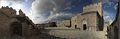
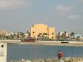
- The Alcazaba, a medieval fortress that was begun in the 10th century but destroyed by an earthquake in 1522. It includes a triple line of walls, a majestic keep and large gardens. It commands a city quarter with buildings dressed in pastel colors, of Muslim-age aspect. It is the second largest among the Muslim fortresses of Andalusia, after the Alhambra.[بحاجة لمصدر]
- Almería air raid shelters, underground galleries for civilian protection during the Spanish Civil War, currently the longest in Europe open for tourists.
- The Cathedral has a fortress-like appearance due to its towers, merlons and protected paths, created to defend it from Mediterranean pirates. Originally designated as a mosque, it was later converted into a Christian church, before being destroyed in the 1522 earthquake. In the 16th century it was rebuilt in the Renaissance style, whilst keeping some of its defensive features.
- Renaissance church of Santiago, built in 1533, with tower and portal decorated with reliefs.
- Chanca, a group of houses carved into rocks.
- Castle of San Cristobal, now in ruins. It is connected to the Alcazaba by a line of walls.
- Museum of Almería. Includes findings from Prehistoric, Iberic, Roman, Greek ages and Muslim objects, mostly from the Alcazaba.
- Paseo de Coches, a modern seaside promenade with gardens and palms.
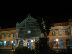
- Cable Inglés (English Pier), 1904 iron railway pier built to transfer iron ore, copper, and silver produced by British- and French-run mines in Granada from trains to waiting cargo ships.
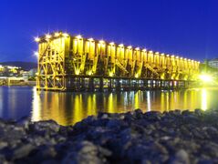
Cable Inglés, at night
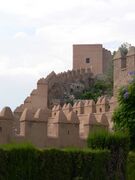
Alcazaba of Almería
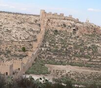
The ancient walls of Jayrán
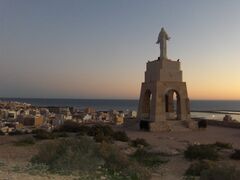
The statue of San Cristóbal
The former train station


الاقتصاد


Intensive agriculture has been the most important economic sector of Almería for the last 50 years.[18] Nowadays, greenhouse's production, handling and commercialisation of vegetables, and the supply industry of the sector, represent almost 40% of Almería's GDP. Directly, agricultural production accounts for 18.2% of the provincial GDP. In Andalusia, the average contribution is 6.6% and in Spain it is only 2.9%.[19]
الجغرافيا
_Greenhouses_of_Almer%C3%ADa,_Spain_(cropped).jpg&filetimestamp=20220805024443&)
Due to its arid landscape, numerous Spaghetti Westerns were filmed in Almería and some of the sets are still remain as a tourist attraction.[20][21] These sets are located in the desert of Tabernas. The town and region were also used by David Lean in Lawrence of Arabia (1962), John Milius in The Wind and the Lion (1975) and others.
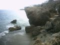
One of Almería's most famous natural spots is the Cabo de Gata-Níjar Natural Park. This park is of volcanic origin,[22] and is the largest and most ecologically significant marine-terrestrial space in the European Western Mediterranean Sea.[بحاجة لمصدر] The Cabo de Gata-Níjar Natural Park runs through the municipal areas of Níjar, Almerimar and Carboneras. Its villages, previously dedicated to fishing, have become tourism spots. The beaches of Cabo de Gata-Níjar Natural Park are also an attraction.[23]
Almería has one islet that it administers as a part of its territory in the Alboran Sea, Alboran Island. The island has a small cemetery, a harbor, and a lighthouse, built in the 19th century.
المناخ
| متوسطات الطقس لالمرية (المطار) | |||||||||||||
|---|---|---|---|---|---|---|---|---|---|---|---|---|---|
| شهر | يناير | فبراير | مارس | أبريل | مايو | يونيو | يوليو | أغسطس | سبتمبر | اكتوبر | نوفمبر | ديسمبر | السنة |
| متوسط العظمى °م (°ف) | 16.9 (62) | 17.7 (64) | 19.2 (67) | 21.0 (70) | 23.6 (74) | 27.3 (81) | 30.3 (87) | 30.7 (87) | 28.3 (83) | 24.3 (76) | 20.4 (69) | 17.9 (64) | 23٫1 (74) |
| متوسط الصغرى °م (°ف) | 8.2 (47) | 8.8 (48) | 10.1 (50) | 11.9 (53) | 14.6 (58) | 18.2 (65) | 21.1 (70) | 22.0 (72) | 19.6 (67) | 15.7 (60) | 12.0 (54) | 9.4 (49) | 14٫3 (58) |
| هطول الأمطار cm (بوصة) | 2.3 (0.9) | 2.1 (0.8) | 1.5 (0.6) | 2.0 (0.8) | 1.4 (0.6) | 1.0 (0.4) | 0 (0) | 0 (0) | 1.2 (0.5) | 2.8 (1.1) | 2.8 (1.1) | 2.3 (0.9) | 19٫6 (7٫7) |
| المصدر: Agencia Estatal de Meteorología[24] | |||||||||||||

آثار ومعالم
تبقى في المدينة آثار بسيطة لمسجدها الكبير الذى تحول إلى كنيسة سان خوان، وهذه الآثار لاتزيد عن المحراب وجدار القبلة، ويزين المحراب طبقة جصية تحتشد فيها زخرفة من التوريقات يرجع بعضها إلى عصر الخلافة، والبعض الآخر إلى عصر الموحدين الذين أصلحوا المسجد بعد أن خلصوا المرية من احتلال جيوش قشتالة. وتبقى أيضًا في ربض الحوض وعلى مقربة من طريق شانكا بقايا جدران منزل مكسوة بطبقة جيرية عليها زخارف هندسية مخططة بخطوط تؤلف أربعة أنواع من التكوينات الهندسية المتشابكة، ويغلب على الظن أن هذه الدار ترجع إلى عصر المرابطين لتشابه هذه الزخارف بزخارف قصر منتقوط بمرسية
مدن شقيقة
. . . . . . . . . . . . . . . . . . . . . . . . . . . . . . . . . . . . . . . . . . . . . . . . . . . . . . . . . . . . . . . . . . . . . . . . . . . . . . . . . . . . . . . . . . . . . . . . . . . . . . . . . . . . . . . . . . . . . . . . . . . . . . . . . . . . . . . . . . . . . . . . . . . . . . . . . . . . . . . . . . . . . . . .
كهف البلور
In 2000, a team of geologists found a cave filled with giant gypsum crystals in an abandoned silver mine near Almería. The cavity, which measures 8 by 1.8 by 1.7 metres (26.2 ft × 5.9 ft × 5.6 ft), may be the largest geode ever found.[25] The entrance of the cave was blocked by five tons of rocks, and was under police protection (to prevent looters from entering). According to geological models, the cave was formed during the Messinian salinity crisis 6 million years ago, when the Mediterranean sea evaporated and left thick layers of salt sediments (evaporites). The site is currently open for tourists under guided tours.
صور
Alcazaba - Inner Courtyard
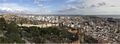
Almeria - from Alcazaba
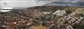
Almeria - from Alcazaba
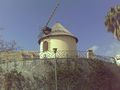
Díaz Mill
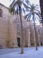
Cathedral-Fortress of Almería
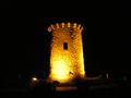
Cárdenas tower
Casino de Almería
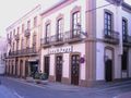
Casa Puga, old restaurant of typical almerian gastronomy
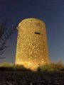
Perdigal tower
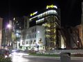
Cajamar at night
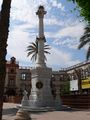
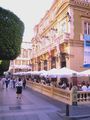
Plaza de la Constitución
Auditory of Almería
Nijar Coast


.jpg)


.jpg&filetimestamp=20220805024444)
_Greenhouses_of_Almer%C3%ADa,_Spain_(cropped).jpg&filetimestamp=20220805024443)
الهامش
|
وصلات خارجية
- Search Almeria Spain information in English & Spanish
- TourSpain Almeria
- (بالإسپانية) Ayuntamiento de Almería
- (بالإسپانية) Almería, Historia y Turismo
- www.andalucia.com/cities/almeria.htm
- Maps of Almería
- (بالإسپانية) Almería Football Club
- "Almería's History"
- Directory of maps and properties for sale in Almería
- Infomation about Almeria, and Spanish properties for sale in Almería
- Almeriaclips - Videos musicales rodados en Almería - Music videos shot in Almería
- Fiesta, song from The Pogues dedicated to Almería
- (بالإسپانية) Almería - Diputación Provincial de Almería
- Viva Almeria community information & photos
- CS1 الإسبانية-language sources (es)
- CS1 errors: unsupported parameter
- Short description is different from Wikidata
- Pages using infobox settlement with unknown parameters
- Articles with hatnote templates targeting a nonexistent page
- Articles with unsourced statements from July 2013
- Articles with unsourced statements from July 2021
- Articles with unsourced statements from March 2019
- مدن الأندلس
- تأسيسات 955
- بلديات مقاطعة المرية
- مقاطعة المرية
- مدن اسبانيا
- تاريخ الأندلس